Rue Sainte-Catherine (Lyon)

Last updated
Rue Sainte-Catherine
Rue Sainte-Catherine.JPG
Former name(s) Rue de la Fontaine
Rue de la Commission temporaire
Location 1st arrondissement of Lyon, Lyon, France
Postal code 69001
Construction
Construction start 17th century

The rue Sainte-Catherine is a very old street at the foot of the slopes of La Croix-Rousse quarter, in the 1st arrondissement of Lyon. It is particularly known for being a drinking street. The street belongs to the zone classified as World Heritage Site by UNESCO.

Contents

Location

The rue Sainte-Catherine has an east-west axis and is parallel of the Place des Terreaux, and therefore is in the historic center of Lyon, overlooking the Hôtel de Ville of the 1st arrondissement. This situation is relatively unusual because it is quite rare for a street with a bad reputation to be as close to the City Hall of a big city, to the richest shopping areas (rue Édouard-Herriot, rue de la République...), to the Opera Nouvel and to the Musée des beaux-arts de Lyon  : this is a paradox indeed very representative of the spirit of the slopes of the Croix-Rousse quarter, which the last "flat" street before the slopes, the rue Sainte-Catherine, is the natural boundary, geographic alter ego of the Boulevard de la Croix-Rousse.

History

The street was first named rue de la Fontaine in the sixteenth century, as a source belonging to the Hospice de la Charité provided drinking water to the entire neighborhood, then rue de la Commission temporaire after 1793. [1]

In 1680, a street and a place named Sainte-Catherine are attested, named after a treatment facility for orphans located on this square. There was indeed a hospital named St. Catherine Hospital, later replaced by the Adopted Daughters of Charity. The name of the street refers to St. Catherine of Alexandria, a saint much worshipped in the Middle Ages who died in 307 as martyr under Maximinus. [2] The hospital was later occupied by the Duparc house. [3]

The house named Le Dauphin, at No. 1, was owned by the Duke of Villeroy. [4] In 1780, an ancient altar was found in the Hôtel des Quatre Nations, at No. 5, belonging to Jacques Imbert Colomès. At No. 9 to 13, the villa owned by Governor Philippianus had a household altar. [1] The first silk mill in France was established in the street. [3]

At the corner of the rue d'Algérie and the rue Saint-Marie-des-Terreaux, a statue of Catherine of Alexandria, carved in 1866 by Joseph-Hughes Fabisch to replace a seventeenth century work by Bridant, also recalls the memory of this hospital which depends the Hôpital de la Charité de Lyon. [5] Over the centuries, several names were used (marché du Fillet, place du Fil, place Neuve-des-Carmes, rue du Forès) and another rue Sainte-Catherine is attested in 1831 in the 4th arrondissement (the current rue Saint-Charles-Francois-Lebrun). There was also a small rue Sainte-Catherine and a Grande rue Sainte-Catherine. On 4 August 1854, the Petite rue Sainte-Catherine became the rue Jean-François-Terme and the current rue Sainte-Catherine took its final name. The Place Sainte-Catherine was then included in the street of the same name. [6] The No. 5 was, in 1868, the headquarters of the Fanfare Lyonnaise, led by Joseph Luigini. [1] On 9 February 1943, the Germans arrested 86 people at the headquarters of the Union Générale des Juifs de France at No. 12 during the events of the Rue Sainte-Catherine Roundup. [7]

Following the more restrictive measures taken by local authorities and the recent decision to renovate the neighborhood slopes (passage Thiaffait, montée de la Grande Côte...), it seems that the atmosphere of the rue Sainte-Catherine tends to evolve gradually to a relative calm and gentrification, since many bars are now closed and some of them are replaced by respectable pubs for middle-class youth, including the Shamrock. In addition, the inhabitants of the street complained about the presence of dealers. [8]

Architecture and description

The street is short and wide to the west with a white building at No. 2, built around 1850. In the northern side, there are two big five-floor houses. After the No. 7, a Madonna and Child [9] the street is more narrow and curved. The three to five-floor houses are old whose simple facades display some sculpted doors and archways. [7]

The street is famous for its many bars, since its central position made it able to drain a large population which come from the Croix-Rousse as well as from the Presqu'île, from Saint-Jean and Saint-Paul quarters (by the bridge La Feuillée) and from the 6th arrondissement by the bridge Morand. The metro station "Hôtel de Ville" is served by A and C lines, and there are many buses until quite late, allowing the rue Sainte-Catherine to be much more active on night, and often even completely congested with people in the middle of the night. The street remains famous for its many bars and pubs (l'Abreuvoir, le Shamrock, le Perroquet Bourré, l'Albion, le Douala...), surrounded with kebabs and groceries shops. It is also known for its popular and festive atmosphere. There are also a mixed sauna and an hotel. [7]

Traboules

There are several traboules in the street: [10]

Related Research Articles

Joseph-Hugues Fabisch French sculptor

Joseph-Hugues Fabisch was a French sculptor. He was professor at the École des Beaux-Arts de Lyon, and official sculptor to the diocese of Lyon.
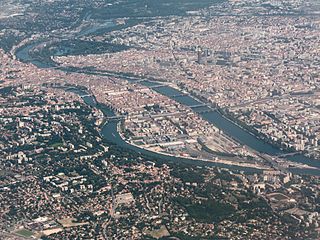
1st arrondissement of Lyon Municipal arrondissement in Auvergne-Rhône-Alpes, France

The 1st arrondissement of Lyon, France is one of the nine arrondissements of the City of Lyon. It is located below the hill of Croix-Rousse and on the north part of the Presqu'île formed by the Saône and the Rhône, the two rivers in Lyon.

Place des Terreaux

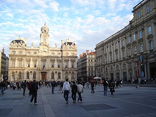
The Place des Terreaux is a square located in the center of Lyon, France, on the Presqu'île between the Rhône and the Saône, at the foot of the hill of La Croix-Rousse in the 1st arrondissement of Lyon. The square belongs to the zone classified as a World Heritage Site by UNESCO.

Place Sathonay

The Place Sathonay is a square located in the 1st arrondissement of Lyon, France, at the bottom of hill of La Croix-Rousse, in La Martinière quarter. It was named after Nicolas-Marie-Jean-Claude Fay de Sathonay, mayor of Lyon from 1805 to 1812, as a tribute for all the importants works undertaken under his presidency. The square is currently the third largest square in Lyon and belongs to the zone classified as World Heritage Site by UNESCO. According to Lyon geography agrégé Jean Pelletier, it is "one of the most interesting squares of Lyon", because of its harmonious proportions, its boundaries composed of buildings with beautiful 1920s facades, and its plantations, which brings "a charm tinged of poetry" and give it the appearance of a village square.

Passage Thiaffait

The Passage Thiaffait is an urban area located on the slopes of La Croix-Rousse, in the 1st arrondissement of Lyon. It has an entry by a portico and is a curved traboule (path) which ends with a staircase leading to the hill. The street belongs to the zone classified as World Heritage Site by UNESCO.

The Rue Édouard-Herriot is one of the most important shopping streets of the Presqu'île in Lyon. It links the two most famous places of the city, the Place Bellecour (south) and the Place des Terreaux (north). Its northern part is located in the 1st arrondissement of Lyon, but the main part of the street is in the 2nd arrondissement. In its southern part, the street passes through the Place des Jacobins. It belongs to the zone classified as World Heritage Site by UNESCO.

Montée des Carmélites

The Montée des Carmélites is one of the oldest streets of Lyon, dating from Roman times, located in the 1st arrondissement of Lyon. It connects the Saint-Vincent quarter to the Plateau de la Croix-Rousse. It is situated between the rue de la Tourette and the rue Ray Fernand, and ends at the intersection of the rue Burdeau, rue du Jardin des Plantes and rue de l'Annonciade.

Cour des Voraces

The Cour des Voraces, also called Maison de la République, is a courtyard building in the Pentes quarter, in the 1st arrondissement of Lyon, famous for its enormous six-floor stairway. It is an impressive traboule, a covered passage with entrances on Place Colbert, Montée Saint-Sébastien and Rue Imbert-Colomès.

Rue Lanterne

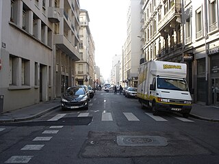
The Rue Lanterne is one of the oldest streets of Lyon, created in the Middle Ages, which is located in the 1st arrondissement of Lyon. It begins after the rue d'Algérie and ends against a facade of the rue Longue.

Montée de la Grande Côte

The Montée de la Grande Côte, or the Montée de la Grande-Côte, is a street of La Croix-Rousse quarter, located in the 1st arrondissement of Lyon, connecting the Terreaux quarter and the Plateau de la Croix Rousse. It is characterized by a high elevation and is more narrow at the bottom. The street belongs to the zone classified as World Heritage Site by UNESCO.

Rue de lArbre-Sec

The Rue de l'Arbre-Sec is an old street located in the 1st arrondissement of Lyon, near the Place des Terreaux and the Opera Nouvel. It starts perpendicular to the rue Édouard-Herriot and ends with the Quai Jean Moulin crossing the rue de la République. The name dates from the 14th century and was probably chosen because of a dry tree that could be seen in this street and of an inn sign.

Rue Burdeau

The Rue Burdeau is a street located in the 1st arrondissement of Lyon, at the bottom of the slopes of La Croix-Rousse, just above the Église Saint-Polycarpe, between the Saône and the Rhône. It leads at one side to the Montée Saint-Sébastien and at the other to the Jardin des Plantes and crosses the montée de la Grande Côte which renovation is completed. The street belongs to the zone classified as World Heritage Site by UNESCO.

Rue Royale, Lyon

The Rue Royale is a street located in the 1st arrondissement of Lyon and was the main street of the quarter when it was created. It starts between the Place Servetus and the Rue de Provence and ends by joining the Grande Rue des Feuillants. There are many traboules closed which link the street with the Quai Lassagne and the rue d'Alsace-Lorraine. It is served by line C of the metro.

Rue dAusterlitz Street in Lyon, France

The Rue d'Austerlitz is a street in the 4th arrondissement of Lyon, in La Croix-Rousse quarter. It begins on the rue du Mail, at the corner of Place de la Croix-Rousse, crosses the rue du Pavilion, the rue de Belfort and the rue Aimé Boussange, and ends on Place Bellevue. Its name refers to the Battle of Austerlitz, one of the greatest victories of Napoleon. There are metro and velo'v stations.

Rue Lainerie

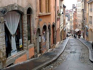
The Rue Lainerie is an ancient cobbled pedestrian street of the Vieux Lyon quarter, in the 5th arrondissement of Lyon. From north to south, it connects two quarters, Saint-Paul and Saint-Jean, and more precisely the Place du Change and the Place Saint-Paul. There is currently an academy of music at No. 1 and many hotels. The street is served by many buses (29-30-31-44-184), two metro stations and a velo'v station. It belongs to the zone classified as World Heritage Site by UNESCO.

The Rue Dumenge is a street located in the 4th arrondissement of Lyon, in the quarter of La Croix-Rousse. It begins on the rue du Mail, crosses the rue du Pavillon and the rue de Belfort and ends on the rue Dumont-d'Urville. The street is served by a metro station of the line C and a velo'v station.

Rue du Bœuf

The Rue du Bœuf is a 188-metre cobbled pedestrian street of the Vieux Lyon quarter, located in the 5th arrondissement of Lyon. Very representative of the Renaissance architecture of the neighborhood, it is lined only with old houses from the 16th or 17th century. The street connects the rue de Gadagne which it continues after the Place du Petit Collège and the intersection of the rue du Chemin Neuf, the rue de la Bombarde and the rue Tramassac which prolongs it. The street belongs to the zone classified as World Heritage Site by UNESCO.

Rue des Capucins

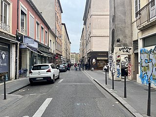
The Rue des Capucins is a street located in the 1st arrondissement of Lyon, between the slopes of La Croix-Rousse and the Place des Terreaux. Straight but slightly inclined, it continues the rue du Sergent Blandan, begins with the Place des Capucins and ends on the Place Croix-Paquet. It is parallel to the rue René Laynaud. The street belongs to the zone classified World Heritage Site by UNESCO.

Place Croix-Paquet

The Place Croix-Paquet is a square located in the 1st arrondissement of Lyon, in the pentes de la Croix-Rousse quarter. It is formed by the intersection of the rue du Griffon, the rue des Capucins and the montée Saint-Sébastien. The square belongs to the zone classified World Heritage Site by UNESCO.

References

  1. 1 2 3 Meynard, Louis (1932). Dictionnaire des lyonnaiseries — Les hommes. Le sol. Les rues. Histoires et légendes (in French). Vol. 4 (1982 ed.). Lyon: Jean Honoré. pp. 35–37.
  2. Pelletier, Jean (1985). Lyon pas à pas — son histoire à travers ses rues — Rive droite de la Saône, Croix-Rousse, quais et ponts de la Saône (in French). Roanne / Le Coteau: Horvath. p. 184. ISBN   2-7171-0377-5.
  3. 1 2 Vachet, Adolphe (1902). À travers les rues de Lyon (in French) (1982, Marseille ed.). Lyon: Laffitte reprints. p. 408. ISBN   2-7348-0062-4.
  4. Brun De La Valette, Robert (1969). Lyon et ses rues (in French). Paris: Le Fleuve. p. 156.
  5. "Les saints et madones du 1er" (in French). Mairie du 1er Lyon. Archived from the original on 18 July 2011. Retrieved 10 December 2009.
  6. Vanario, Maurice (2002). Rues de Lyon à travers les siècles. Lyon: Éditions lyonnaises d'art et d'histoire. p. 262. ISBN   2-84147-126-8.
  7. 1 2 3 "Rue Saint-Catherine" (in French). Rues de Lyon. Retrieved 10 December 2009.
  8. Menvielle, Dominique (14 May 2009). "Rue Sainte-Catherine: trop de désordres et peu de solutions". Le Progrès (in French). Lyon. Archived from the original on 7 August 2009. Retrieved 10 December 2009.
  9. "Listing des Saints et Madones du 1er" (PDF) (in French). Lyon. Archived from the original (pdf) on 18 July 2011. Retrieved 27 January 2010.
  10. Dejean, René (1988). Traboules de Lyon — Histoire secrète d'une ville (in French). Le Progrès. pp. 88–90. ISBN   2-904899-01-4.

Coordinates: 45°46′05″N4°49′59″E / 45.76806°N 4.83306°E / 45.76806; 4.83306