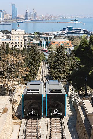
A funicular is a type of cable railway system that connects points along a railway track laid on a steep slope. The system is characterized by two counterbalanced carriages permanently attached to opposite ends of a haulage cable, which is looped over a pulley at the upper end of the track. The result of such a configuration is that the two carriages move synchronously: as one ascends, the other descends at an equal speed. This feature distinguishes funiculars from inclined elevators, which have a single car that is hauled uphill.

The Lyon Metro is a rapid transit system serving Lyon Metropolis, France. First opened in 1974, it currently consists of four lines, serving 42 stations and comprising 34.4 kilometres (21.4 mi) of route. Part of the Transports en Commun Lyonnais (TCL) system of public transport, it is supported by two funiculars and a tramway network.

Line A is a line on the Lyon Metro that runs between Perrache and Vaulx-en-Velin–La Soie. It was constructed using the cut-and-cover method, and went into service on 2 May 1978. It, together with Line B, were the inaugural lines of the Lyon Metro. An extension of Line A from Laurent Bonnevay–Astroballe to Vaulx-en-Velin–La Soie opened in 2007. The line currently serves 14 stations, and is 9.2 kilometres (5.7 mi) long. Line A trains run on tires rather than steel wheels; it is a rubber-tired metro line.
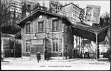
The Funiculars of Lyon is a network of funicular railways in Lyon, France. Of the five lines once in existence, only the two routes on the Fourvière hill remain in operation, with the rest of the network now either closed, converted to road vehicle use, or integrated within the Lyon underground system.
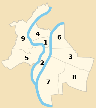
The nine arrondissements of Lyon are the administrative divisions of the City of Lyon. Unlike the spiral pattern of the arrondissements of Paris, or the meandering pattern of those in Marseille, the layout in Lyon is more idiosyncratic. This is for historical reasons: following the annexation of the communes of La Guillotière, La Croix-Rousse and Vaise in 1852, the newly enlarged city was divided into 5 arrondissements, which originally spiralled out anticlockwise from the Hôtel de Ville ; however, as the city's population expanded, it became necessary to split certain arrondissements, giving rise to today's seemingly random pattern.

The Transports en commun lyonnais is the Lyon public transport agency. It is the second largest public transport system in France, and covers 73 communes, including all 59 communes of the Lyon Metropolis, spread over 746 square kilometres (288 sq mi).

The Montmartre Funicular is an inclined transport system serving the Montmartre neighbourhood of Paris, France, in the 18th arrondissement. Operated by the RATP, the Paris transport authority, the system opened in 1900; it was entirely rebuilt in 1935 and again in 1991.

The Lyon tramway comprises eight lines, seven lines operated by TCL and one by Rhônexpress in the city of Lyon in Auvergne-Rhône-Alpes, France. The original tramway network in Lyon was developed in 1879, and the modern network was built in 2001.
Rhône-Alpes is a major European transit hub, linking northern France and Europe to the Mediterranean area. Millions travel along its motorways in summertime from Paris to holidays at the sea. The E15 Euroroute runs through the region. There are international airports at Lyon, Grenoble and Saint-Étienne and many other minor airports and airfields.

The 1st arrondissement of Lyon, France is one of the nine arrondissements of the City of Lyon. It is located below the hill of Croix-Rousse and on the north part of the Presqu'île formed by the Saône and the Rhône, the two rivers in Lyon.

The Rue de la République is a street located in the 1st and 2nd arrondissements of Lyon, France. It links the Place de la Comédie in the north to Place Le Viste in the south, just next to Place Bellecour, via the Place de la République.
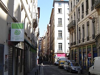
The rue Sainte-Catherine is a very old street at the foot of the slopes of La Croix-Rousse quarter, in the 1st arrondissement of Lyon. It is particularly known for being a drinking street. The street belongs to the zone classified as World Heritage Site by UNESCO.

The Rue Royale is a street located in the 1st arrondissement of Lyon and was the main street of the quarter when it was created. It starts between the Place Servetus and the Rue de Provence and ends by joining the Grande Rue des Feuillants. There are many traboules closed which link the street with the Quai Lassagne and the rue d'Alsace-Lorraine. It is served by line C of the metro.

The Place Croix-Paquet is a square located in the 1st arrondissement of Lyon, in the pentes de la Croix-Rousse quarter. It is formed by the intersection of the rue du Griffon, the rue des Capucins and the montée Saint-Sébastien. The square belongs to the zone classified World Heritage Site by UNESCO.

The Belleville funicular tramway was a cable car which from 1891 to 1924 connected the Place de la République in Paris to the Église Saint-Jean-Baptiste de Belleville, on a hill in the Belleville quarter. It has since been demolished.

The Funiculaire de Cossonay is a funicular railway connecting the town of Cossonay in the Swiss canton of Vaud with Cossonay-Penthalaz railway station, on the line from Lausanne to Vallorbe and Yverdon-les-Bains. The lower funicular station is called Cossonay-Gare, but is in the village of Penthalaz. The upper station, some 130 metres (430 ft) above, is named Cossonay-Ville. The line has a length of 1228 m at a maximum incline of 13%.

Boulevard de la Croix-Rousse is a boulevard that marks the border between the 1st and the 4th arrondissements of Lyon, in the neighborhood Croix-Rousse.

Hôtel de Ville–Louis Pradel is a transfer station in the Lyon Metro, providing a connection between lines A and C. The station is located in the Presqu'île of Lyon, France. Serving Lyon's 1st arrondissement, the station is near Lyon City Hall with access to Place des Terreaux, Opéra Nouvel, Museum of Fine Arts of Lyon, and other nearby attractions. The station is a major interchange and is Line C's southern terminus providing its only connection with the rest of the metro system.