Rue des Marronniers

Last updated
Rue des Marronniers
Rue Maronniers Lyon2 fr.JPG
The rue des Marronniers, viewed from the Place Antonin-Poncet
Width8 m
Location 2nd arrondissement of Lyon, Lyon, France
Postal code69002
Construction
Construction start18th century

The Rue des Marronniers is a street located in the Bellecour quarter, in the 2nd arrondissement of Lyon. It is a small paved pedestrian street famous for its many bouchons. It is served by the metro station Bellecour and many buses. The street belongs to a zone classified as a World Heritage Site by UNESCO.

2nd arrondissement of Lyon French municipal arrondissement in Rhône-Alpes, France

The 2nd arrondissement of Lyon is one of the nine arrondissements of the City of Lyon.

Bouchon refers to cooking traditions and practices centering on the area around the French city of Lyon

A bouchon is a type of restaurant found in Lyon, France, that serves traditional Lyonnaise cuisine, such as sausages, "salade lyonnaise" duck pâté or roast pork. The speciality is "Quenelles de Brochet"(Pike Quenelles) with Nantua Sauce. Compared to other forms of French cooking such as nouvelle cuisine, the dishes are quite fatty and heavily oriented around meat. There are approximately twenty officially certified traditional bouchons, but a larger number of establishments describe themselves using the term.

World Heritage Site place listed by the UNESCO as of special cultural or natural significance

A World Heritage Site is a landmark or area which is chosen by the United Nations Educational, Scientific and Cultural Organisation (UNESCO) as having cultural, historical, scientific or other form of significance, and is legally protected by international treaties. The sites are judged important to the collective interests of humanity.

Contents

History

Located near the Place Bellecour and the Place Antonin-Poncet, the street was named after the trees that lined the square (they have since been removed) [1] on its eastern side until the eighteenth century, [2] after being named rue de Jérusalem, then rue Neuve des Basses-brayes. [3] Its current name was chosen by consular decree of 30 September 1723. [4] It was drawn in the early eighteenth century, during the construction of buildings to the east of the Place Bellecour.

Place Bellecour large square in the city of Lyon

La Place Bellecour is a large square in the centre of Lyon, France, to the north of the Ainay district. Measuring 312 m by 200 m, it is one of the largest open squares in Europe, and the third biggest square in France, behind the Place des Quinconces in Bordeaux (126,000 m²) and the Place de la Concorde in Paris (86,400 m²). It is also the largest pedestrian square in Europe: vehicles are allowed in Places de la Concorde and des Quinconces.

Place Antonin-Poncet public square in Lyon, France

The Place Antonin-Poncet is a square located in the Bellecour quarter, near the Place Bellecour, in the 2nd arrondissement of Lyon, France. It is served by the metro station Bellecour of the lines A and D, and by many buses (10-12-14-15-29-30-35-53-58-88-99). The square belongs to the zone classified as World Heritage Site by UNESCO.

Mayor of Lyon and member of the National Assembly Démophile Laforest lived here in the 1849. Many architects participated in the construction of buildings, including Pierre Gauthier (No. 1), Marc-Antoine Trollier (No. 5), Melchior Munet (No. 7), Gabriel Rigod (No. 11). Even numbers 2 to 10 were built in 1714, demolished in 1793 and rebuilt in 1810. [5]

The street became pedestrian in the late twentieth century.

Architecture and notable monuments

The Théâtre des Marronniers is the most famous monument of the street.

In 1952, Roger Planchon created the Théâtre de la Comédie at number 3 bis, a former locksmith's workshop. When he left Lyon for Villeurbanne, Marcel Maréchal succeeded him and installed the Théâtre du Cothurne. Many famous actors did their training here (Pierre Arditi, Catherine Arditi, Marcel Bozonnet, Maurice Bénichou or Bernard Ballet). In 1986, the small theatre was turned into a cinema named CNP Bellecour, [6] currently open on the Rue de la Barre. [7]

Roger Planchon, was a French playwright, director, filmmaker.

Villeurbanne Commune in Auvergne-Rhône-Alpes, France

Villeurbanne is a commune in the Metropolis of Lyon in Auvergne-Rhône-Alpes region in eastern France.

Pierre Arditi French actor

Pierre Arditi is a French actor. He is the brother of French actress Catherine Arditi.

As of 2008, there is still a Théâtre des Marronniers, but it is now at number 7.

The traboule at No. 3 bis crosses four buildings and has an interesting architecture. It starts with a porte-cochere and leads to the former Théâtre des Marronniers. It has two outputs: the first one ends with a semicircular gate, a paved floor and a Louis XVI-styled building, and the second one, blocked up, is in the same three-floor building but higher. [8]

Related Research Articles

Rue Victor-Hugo, Lyon pedestrian street in the 2nd arrondissement of Lyon, France

Rue Victor-Hugo is a pedestrian street in the 2nd arrondissement of Lyon, in the Ainay district of the Presqu'île quarter, reputed to be one of the most known shopping area of Lyon. From north to south, it connects the Place Bellecour to the Place Carnot. Beyond the Place Bellecour, the rue de la République is its natural extension, thus creating one of the biggest pedestrian streets in Europe. The street is served by metro stations Perrache, Bellecour and Ampère - Victor Hugo. It belongs to the zone classified as World Heritage Site by UNESCO.

Place des Célestins square in Lyon, France

The Place des Célestins is a square located in the Célestins quarter, in the 2nd arrondissement of Lyon. The square was named after the religious of the Order of the Celestines which were installed from 1407 to 1778. Redevelopment in 1995 added an underground car park. This zone is served by the metro station Bellecour. It belongs to the zone classified as World Heritage Site by UNESCO.

Rue Mercière street in Lyon

Rue Mercière is a street of Les Cordeliers quarter in the 2nd arrondissement of Lyon. From north to south, it connects the Place des Jacobins to the Place d'Albon. This street is served by metro stations Bellecour and Cordeliers of the line  A  and by the bus station Jacobins of the lines 91 and 99. It belongs to the zone classified as World Heritage Site by UNESCO.

Place de la République, Lyon public square in Lyon, France

The Place de la République is a square located in the Bellecour quarter, in the 2nd arrondissement of Lyon. It belongs to the zone classified as World Heritage Site by UNESCO.

Place Ampère pedestrian square in the Ainay square, in the 2nd arrondissement of Lyon

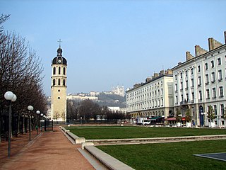
The Place Ampère is a pedestrian square located in the Ainay square, in the 2nd arrondissement of Lyon. It is nearly the middle of the rue Victor-Hugo and is served by the metro station Ampère - Victor Hugo.

Passage Thiaffait urban area in Lyon, France

The Passage Thiaffait is an urban area located on the slopes of La Croix-Rousse, in the 1st arrondissement of Lyon. It has an entry by a portico and is a curved traboule (path) which ends with a staircase leading to the hill. The street belongs to the zone classified as World Heritage Site by UNESCO.

Cours Charlemagne street in Lyon, France

The Cours Charlemagne is a large central street located in the Perrache quarter, in the 2nd arrondissement of Lyon. This street is dedicated to Charlemagne, who came several times to Lyon. In addition, the bishop Leidrade represented the emperor in the city and by his great work of reconstruction. The Cours Charlemagne begins Place des Archives, just at the south of the vaults of the interchange of Perrache. It ends on the Quai Perrache, which overlooks the Pont Pasteur.

Rue de Brest street in Lyon, France

The Rue de Brest is a street located in the 2nd arrondissement of Lyon. This is one of the main shopping and tourist streets of the city center, parallel to the rue Édouard-Herriot. It begins in the wake of the rue Paul Chenavard and ends with the Place des Jacobins.

Rue de la Bourse street in Lyon, France

The Rue de la Bourse is a street located mainly in the 2nd arrondissement of Lyon, and also in the 1st arrondissement. It starts on the Place des Cordeliers, in the 2nd arrondissement, in front of the Église Saint-Bonaventure, and ends at right angles to the Rue du Bât-d'Argent, beyond which it is extended by the Rue du Garet.

Montée des Carmélites thoroughfare in Lyon, France

The Montée des Carmélites is one of the oldest streets of Lyon, dating from Roman times, located in the 1st arrondissement of Lyon. It connects the Saint-Vincent quarter to the Plateau de la Croix-Rousse. It is situated between the rue de la Tourette and the rue Ray Fernand, and ends at the intersection of the rue Burdeau, rue du Jardin des Plantes and rue de l'Annonciade.

Rue Lanterne thoroughfare in Lyon, France

The Rue Lanterne is one of the oldest streets of Lyon created the Middle Ages, which is located in the 1st arrondissement of Lyon. It begins after the rue d'Algérie and ends against a facade of the rue Longue.

Rue Sainte-Catherine (Lyon) thoroughfare in Lyon, France

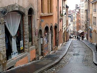
The rue Sainte-Catherine is a very old street at the foot of the slopes of La Croix-Rousse quarter, in the 1st arrondissement of Lyon. It is particularly known for being a drinking street. The street belongs to the zone classified as World Heritage Site by UNESCO.

Montée de la Grande Côte street in the 1st arrondissement of Lyon, France

The Montée de la Grande Côte, or the Montée de la Grande-Côte, is a street of La Croix-Rousse quarter, located in the 1st arrondissement of Lyon, connecting the Terreaux quarter and the Plateau de la Croix Rousse. It is characterized by a high elevation and is more narrow at the bottom. The street belongs to the zone classified as World Heritage Site by UNESCO.

Rue de lArbre-Sec street in Lyon, France

The Rue de l'Arbre-Sec is an old street located in the 1st arrondissement of Lyon, near the Place des Terreaux and the Opera Nouvel. It starts perpendicular to the rue Édouard-Herriot and ends with the Quai Jean Moulin crossing the rue de la République. The name dates from the 14th century and was probably chosen because of a dry tree that could be seen in this street and of an inn sign.

Rue Burdeau street in Lyon, France

The Rue Burdeau is a street located in the 1st arrondissement of Lyon, at the bottom of the slopes of La Croix-Rousse, just above the Église Saint-Polycarpe, between the Saône and the Rhône. It leads at one side to the Montée Saint-Sébastien and at the other to the Jardin des Plantes and crosses the montée de la Grande Côte which renovation is completed. The street belongs to the zone classified as World Heritage Site by UNESCO.

Rue Lainerie street in the 5th arrondissement of Lyon, France

The Rue Lainerie is an ancient cobbled pedestrian street of the Vieux Lyon quarter, in the 5th arrondissement of Lyon. From north to south, it connects two quarters, Saint-Paul and Saint-Jean, and more precisely the Place du Change and the Place Saint-Paul. There is currently an academy of music at No. 1 and many hotels. The street is served by many buses (29-30-31-44-184), two metro stations and a velo'v station. It belongs to the zone classified as World Heritage Site by UNESCO.

Rue du Bœuf street in Lyon, France

The Rue du Bœuf is a 188-metre cobbled pedestrian street of the Vieux Lyon quarter, located in the 5th arrondissement of Lyon. Very representative of the Renaissance architecture of the neighborhood, it is lined only with old houses from the 16th or 17th century. The street connects the rue de Gadagne which it continues after the Place du Petit Collège and the intersection of the rue du Chemin Neuf, the rue de la Bombarde and the rue Tramassac which prolongs it. The street belongs to the zone classified as World Heritage Site by UNESCO.

Rue des Capucins street in the 1st arrondissement of Lyon, France

The Rue des Capucins is a street located in the 1st arrondissement of Lyon, between the slopes of La Croix-Rousse and the Place des Terreaux. Straight but slightly inclined, it continues the rue du Sergent Blandan, begins with the Place des Capucins and ends on the Place Croix-Paquet. It is parallel to the rue René Laynaud. The street belongs to the zone classified World Heritage Site by UNESCO.

Place Croix-Paquet

The Place Croix-Paquet is a square located in the 1st arrondissement of Lyon, in the pentes de la Croix-Rousse quarter. It is formed by the intersection of the rue du Griffon, the rue des Capucins and the montée Saint-Sébastien. The square belongs to the zone classified World Heritage Site by UNESCO.

References

  1. Vachet, Adolphe (1902). À travers les rues de Lyon (in French) (1982, Marseille ed.). Lyon: Laffitte reprints. p. 305. ISBN   2-7348-0062-4.
  2. Pelletier, Jean (1986). Lyon pas à pas — son histoire à travers ses rues — Presqu'île, rive gauche du Rhône, quais et ponts du Rhône (in French). Roanne / Le Coteau: Horvath. p. 50. ISBN   2-7171-0453-4.
  3. Brun De La Valette, Robert (1969). Lyon et ses rues (in French). Paris: Le Fleuve. p. 203.
  4. Vanario, Maurice (2002). Rues de Lyon à travers les siècles (in French). Lyon: ELAH. p. 188. ISBN   2-84147-126-8.
  5. Meynard, Louis (1932). Dictionnaire des lyonnaiseries — Les hommes. Le sol. Les rues. Histoires et légendes (in French). 3 (1982 ed.). Lyon: Jean Honoré. pp. 111–12.
  6. "Chazelles-sur-Lavieu - Théâtre du couvent Saint-Joseph" (PDF) (in French). Archived from the original (PDF) on July 20, 2011. Retrieved May 25, 2009.
  7. "Rue des Marronniers" (in French). Rues de Lyon. Retrieved 25 May 2009.
  8. Dejean, René (1988). Traboules de Lyon — Histoire secrète d'une ville (in French). Le Progrès. p. 130. ISBN   2-904899-01-4.

Coordinates: 45°45′26″N4°50′05″E / 45.75722°N 4.83472°E / 45.75722; 4.83472

Geographic coordinate system Coordinate system

A geographic coordinate system is a coordinate system that enables every location on Earth to be specified by a set of numbers, letters or symbols. The coordinates are often chosen such that one of the numbers represents a vertical position and two or three of the numbers represent a horizontal position; alternatively, a geographic position may be expressed in a combined three-dimensional Cartesian vector. A common choice of coordinates is latitude, longitude and elevation. To specify a location on a plane requires a map projection.