Russell Lake West, Nova Scotia

Last updated
Russell Lake West
Country Canada
Province Nova Scotia
Municipality Halifax Regional Municipality
Community council Harbour East Community Council
Planning Area Dartmouth
Area
[1]
  Total2.51 km2 (0.97 sq mi)

Russell Lake West is a planned residential subdivision and commercial development in the eastern part of the community of Dartmouth in the Halifax Regional Municipality, Nova Scotia. The area began construction in 2006 with the creation of Exit 8 on Highway 111, providing access from the southwest to the area via Mount Hope Avenue, which, as of October 2011, also provides direct access into Woodside Industrial Park. Russell Lake West is located next to the community of Woodside. Walking trails provide direct access to and from Woodside. The subdivision covers 251 ha (620 acres), [2] and houses approximately 3,200 people. [3]

Contents

Business

The primary commercial area of Russell Lake West is located immediately adjacent to Exit 8 from Highway 111. There is a primary retail area centered on the 111 interchange with Mount Hope Avenue, with some pre-existing retail built between 2008 and 2010. More land in the area was zoned for commercial use. The recently constructed retail plaza, called Millstone Square, contains a mixture of small businesses, as well as larger retail tenants.

Millstone Square is a plaza style commercial area and is anchored by Sobeys, Kent Building Supplies, and Lawtons Drugs. Other tenants in Millstone Square include:

List Of Tenants
Restaurants
  • Rocco's
  • Sam's Seafood
  • Grind House Cafe

Health/Wellness & Beauty

  • All Yoga
  • Millstone Square Dental Centre
  • Eye World Ltd. Vision Care
  • Natural Path Wellness Centre
  • RANA Respiratory Care Group
  • Richardson Orthondontics
  • LinMac Hair Design
  • Saigon Nails and Spa

Financial

Professional

  • CB Richard Ellis Global Corporate Services
  • Century 21 A.B.C
  • Eastin Project Limited
  • Meco

Services

  • Russell Lake Animal Hospital
  • Access Nova Scotia

Future Retail Development

A new 20 000 sq. ft. retail center "Baker Drive Centre" is currently available for pre-lease for Baker Dr. near Lindenwood Terrace. A new retail plaza is currently slated to be developed along Baker Dr. opposite to Millstone Square and Sobeys.

Community

The residential portion of Russell Lake West is made up of a mix of low density single-family dwellings, as well as medium-density townhouses, higher-density condominiums, and apartment low-rises. Several of them cater to an elderly demographic. There is also a Shannex residence, "Parkland at the Lakes," located at the bottom of Baker Drive in the area near the lake opposite to Freshwater Trail.

With the neighborhood being located on Russell Lake, with many homes backing directly onto the lake itself, there are restrictions to residents including rules which restrict traffic on the lake due to the wildlife in the area.

An area (yet to be developed) on Basswood Terrace was initially a proposed site for an elementary school. However, due to Portland Estates Elementary School being located on the opposite side of the lake, the Halifax Regional School Board deemed it unnecessary for another school so close. As a result, the site was re-zoned for high-density residentials and is currently awaiting development.

One interesting item in the Russell Lake West area is the Osprey Nest at the northern head of Russell Lake itself near the water shed. The nest is perched on top of a pole placed there by Nova Scotia Power. The pole was put in place after it was noticed that numerous power outages were happening as a result of the nest being on a power pole in the area. Nova Scotia Power also installed a WebCam to view the nest and the egg hatching in Real-time.

The neighborhood covers about 251 ha (620 acres), [4] and houses approximately 3,200 people. [5]

Parks

A series of walking trails run throughout the community, connecting streets at small open greenspaces and playgrounds and providing a connection to the trails that already existed around the north end of the shore of the lake in Russell Lake Park.

Transit

Public transit is provided by Metro Transit on Route #57 which runs along Baker Drive through Russell Lake West, providing connections to the Woodside Industrial Park, the Woodside Ferry Terminal, Penhorn Terminal, Portland Hills Terminal, and connects the adjacent communities of Woodside, Portland Street, Portland Estates, and Portland Hills.

Related Research Articles

<span class="mw-page-title-main">Pictou County</span> County in Nova Scotia

Pictou County is a county in the province of Nova Scotia, Canada. It was established in 1835, and was formerly a part of Halifax County from 1759 to 1835. It had a population of 43,657 people in 2021, a decline of 0.2 percent from 2016. Furthermore, its 2016 population is only 88.11% of the census population in 1991. It is the sixth most populous county in Nova Scotia.

<span class="mw-page-title-main">New Glasgow, Nova Scotia</span> Town in Nova Scotia, Canada

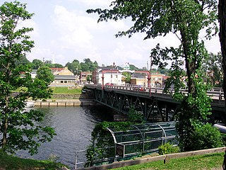
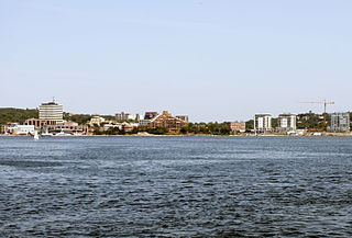
New Glasgow is a town in Pictou County, in the province of Nova Scotia, Canada. It is situated on the banks of the East River of Pictou, which flows into Pictou Harbour, a sub-basin of the Northumberland Strait.
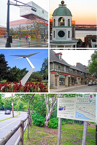
Spryfield is community within the urban area of Halifax, Nova Scotia, Canada.

<span class="mw-page-title-main">Halifax Peninsula</span> Place in Nova Scotia, Canada

The Halifax Peninsula is a peninsula within the urban area of the Municipality of Halifax, Nova Scotia.

<span class="mw-page-title-main">Eastern Passage, Nova Scotia</span> Community in Nova Scotia, Canada

Eastern Passage is an unincorporated suburban community in Halifax Regional Municipality Nova Scotia, Canada.

<span class="mw-page-title-main">Lower Sackville, Nova Scotia</span> Community in Nova Scotia, Canada

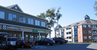
Lower Sackville is a suburban community of the Halifax Regional Municipality, Nova Scotia, Canada.

<span class="mw-page-title-main">Cole Harbour, Nova Scotia</span> Community in Nova Scotia, Canada

Cole Harbour is a former village and current community located in Nova Scotia, Canada that is part of the Halifax Regional Municipality.

<span class="mw-page-title-main">Clayton Park, Nova Scotia</span> Community in Nova Scotia, Canada

Clayton Park is a community within Halifax, Nova Scotia, Canada.

<span class="mw-page-title-main">Downtown Halifax</span> Downtown Area in Nova Scotia, Canada

Downtown Halifax is the primary central business district of the Municipality of Halifax. Located on the central-eastern portion of the Halifax Peninsula, on Halifax Harbour. Along with Downtown Dartmouth, and other de facto central business districts within the Municipality, Downtown Halifax serves as the business, entertainment, and tourism hub of the region.

<span class="mw-page-title-main">Manor Park, Nova Scotia</span> Neighbourhood in Halifax Regional Municipality, Nova Scotia, Canada

Manor Park is a neighbourhood of Dartmouth, Nova Scotia, Canada. The main entrance to the neighbourhood is from the east on Portland Street. A secondary entrance, from the west, is by way of Celtic Drive, rising from the low-lying area around Lake Banook.

<span class="mw-page-title-main">Scotia Square</span> Building complex in Halifax, Nova Scotia

Scotia Square is a commercial development in downtown Halifax, Nova Scotia, Canada. It was built from the late 1960s to late 1970s and is managed by Crombie REIT.

Portland Estates is a suburban neighbourhood in Woodlawn, an area of eastern Dartmouth in the Halifax Regional Municipality, Nova Scotia. It reaches from Eisener Blvd. in the west, all the way to Portland Hills in the east, and is located to the south of Portland Street.

<span class="mw-page-title-main">Burnside, Nova Scotia</span> Neighbourhood in Halifax Regional Municipality, Nova Scotia, Canada

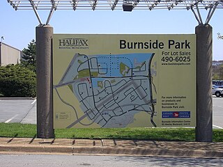
Burnside is a Canadian urban neighbourhood located along the northeast shore of Bedford Basin of the Halifax Regional Municipality in Dartmouth, Nova Scotia.

<span class="mw-page-title-main">Dartmouth Crossing</span> Urban Neighbourhood in Halifax Regional Municipality, Nova Scotia, Canada

Dartmouth Crossing is a commercial real estate development in Dartmouth, a part of Halifax Regional Municipality, Nova Scotia, Canada.

Timberlea is a community located within the Municipality of Halifax in Nova Scotia, Canada.

<span class="mw-page-title-main">Woodside, Nova Scotia</span> Locality in Nova Scotia, Canada

Woodside is an unincorporated middle income urban locality of Dartmouth, within the Halifax Regional Municipality, Nova Scotia. The community is divided into North Woodside and South Woodside. Woodside is home to two hospitals: the Dartmouth General Hospital and the Nova Scotia Hospital.

<span class="mw-page-title-main">Downtown Dartmouth</span> Downtown in Nova Scotia, Canada

Downtown Dartmouth is the main central business district of Dartmouth in Halifax, Nova Scotia, Canada. It is part of the Capital District of the Province.

<span class="mw-page-title-main">Transportation in Halifax, Nova Scotia</span>

Halifax Regional Municipality has a multi-modal transportation network.

<span class="mw-page-title-main">MetroLink (Halifax)</span> Bus rapid transit service in Nova Scotia, Canada

MetroLink was Halifax Regional Municipality's former BRT express bus service, operated by Halifax Transit.

Russell Lake is a small shallow lake in Nova Scotia's Halifax Regional Municipality in the community of Dartmouth. The lake is bounded by the development of Russell Lake West to the west, Woodside to the south, Woodlawn to the north and Portland Estates to the east.

References

  1. "Halifax Regional Municipality Urban Forest Master Plan" (PDF). halifax.ca. Government of the Municipality of Halifax. Retrieved 14 July 2021.
  2. "Halifax Regional Municipality Urban Forest Master Plan" (PDF). halifax.ca. Government of the Municipality of Halifax. Retrieved 14 July 2021.
  3. "Russell Lake West". claytondev.com. Clayton Developments. Retrieved 22 February 2021.
  4. "Halifax Regional Municipality Urban Forest Master Plan" (PDF). halifax.ca. Government of the Municipality of Halifax. Retrieved 14 July 2021.
  5. "Russell Lake West". claytondev.com. Clayton Developments. Retrieved 22 February 2021.

44°39′14.9″N63°31′48.9″W / 44.654139°N 63.530250°W / 44.654139; -63.530250