Ryhall Pasture and Little Warren Verges

Last updated
Ryhall Pasture and Little Warren Verges
Site of Special Scientific Interest

Ryhall Pasture 2.jpg

Ryhall Pasture
Area of Search Lincolnshire
Rutland
Grid reference TF 021 137 [1]
Interest Biological
Area 6.2 hectares [1]
Notification 1983 [1]
Location map Magic Map

Ryhall Pasture and Little Warren Verges is a 6.2 hectare biological Site of Special Scientific Interest north of the village of Ryhall. Little Warren Verges is in Lincolnshire and Ryhall Pasture is in Rutland. [1] [2]

Site of Special Scientific Interest conservation designation denoting a protected area in the United Kingdom

A Site of Special Scientific Interest (SSSI) in Great Britain or an Area of Special Scientific Interest (ASSI) in the Isle of Man and Northern Ireland is a conservation designation denoting a protected area in the United Kingdom and Isle of Man. SSSI/ASSIs are the basic building block of site-based nature conservation legislation and most other legal nature/geological conservation designations in the United Kingdom are based upon them, including national nature reserves, Ramsar sites, Special Protection Areas, and Special Areas of Conservation. The acronym "SSSI" is often pronounced "triple-S I".

Ryhall village in the United Kingdom

Ryhall is a village and civil parish in the county of Rutland in the East Midlands of England. It is situated close to the eastern boundary of the county, about 2 miles (3 km) north of Stamford.

Lincolnshire County of England

Lincolnshire is a county in eastern England, with a long coastline on the North Sea to the east. It borders Norfolk to the south east, Cambridgeshire to the south, Rutland to the south west, Leicestershire and Nottinghamshire to the west, South Yorkshire to the north west, and the East Riding of Yorkshire to the north. It also borders Northamptonshire in the south for just 20 yards (18 m), England's shortest county boundary. The county town is the city of Lincoln, where the county council has its headquarters.

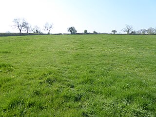
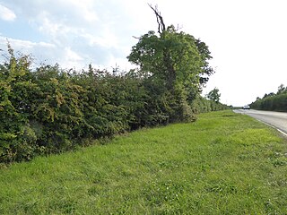
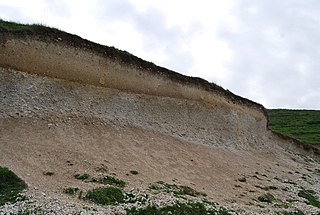
The main grasses on Ryhall Pasture are tor-grass, upright brome and red fescue. The soil is on Jurassic Upper Lincolnshire Limestone, and the rich herb flora include clustered bellflower and greater knapweed. The roadside verges have a diverse calcareous flora, and adjacent hedges are rich in herbs and insect species. [3]

The Jurassic was a geologic period and system that spanned 56 million years from the end of the Triassic Period 201.3 million years ago (Mya) to the beginning of the Cretaceous Period 145 Mya. The Jurassic constitutes the middle period of the Mesozoic Era, also known as the Age of Reptiles. The start of the period was marked by the major Triassic–Jurassic extinction event. Two other extinction events occurred during the period: the Pliensbachian-Toarcian extinction in the Early Jurassic, and the Tithonian event at the end; however, neither event ranks among the "Big Five" mass extinctions.

Calcareous an adjective meaning mostly or partly composed of calcium carbonate

Calcareous is an adjective meaning "mostly or partly composed of calcium carbonate", in other words, containing lime or being chalky. The term is used in a wide variety of scientific disciplines.

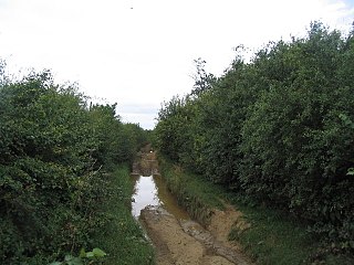
There is public access to the verges but not to the meadow.

Related Research Articles

Brampton Meadow

Brampton Meadow is a one hectare biological Site of Special Scientific Interest north-west of Brampton in Cambridgeshire.

Bloody Oaks Quarry

Bloody Oaks Quarry is a 1.3 hectare biological Site of Special Scientific Interest north-west of Great Casterton in Rutland. It is owned and managed by the Leicestershire and Rutland Wildlife Trust.

Bradfield Woods Suffolk Wildlife Trust nature reserve

Bradfield Woods is an 81.4 hectare biological Site of Special Scientific Interest between Bury St Edmunds and Stowmarket in Suffolk. The site is in three separate blocks, the adjoining Felsham Hall and Monkspark Woods, and the much smaller separate Hedge Wood and Chensil Grove. Felsham Hall and Monkspark Woods are designated a 63.3 National Nature Reserve, also called Bradfield Woods, and are managed by the Suffolk Wildlife Trust.

Cornard Mere Suffolk Wildlife Trust nature reserve

Cornard Mere is an 8.5 hectare biological Site of Special Scientific Interest in Little Cornard in Suffolk. It is managed by the Suffolk Wildlife Trust.

Tilwick Meadow

Tilwick Meadow is a 2.6 hectare biological Site of Special Scientific Interest between Thurleigh and Wilden in Bedfordshire. It was notified in 1988 under Section 28 of the Wildlife and Countryside Act 1981, and the local planning authority is Bedford Borough Council.

Gog Magog Golf Course

Gog Magog Golf Course is an 88.4 hectare biological Site of Special Scientific Interest on Gog Magog Golf Club south-east of Cambridge in Cambridgeshire.

Mill Crook nature reserve in the United Kingdom

Mill Crook is a 5.9 hectare biological Site of Special Scientific Interest east of Towcester in Northamptonshire. Mill Crook and Grafton Regis Meadow are a 7.9 hectare nature reserve managed by the Wildlife Trust for Bedfordshire, Cambridgeshire and Northamptonshire.

Calender Meadows

Calender Meadows is a 3.1 hectare biological Site of Special Scientific Interest north of Guilsborough in Northamptonshire.

Plumpton Pasture

Plumpton Pasture is a 3.6 hectare biological Site of Special Scientific Interest east of Towcester in Northamptonshire.

Hardwick Lodge Meadow

Hardwick Lodge Meadow is a 10 hectare biological Site of Special Scientific Interest north-west of Wellingborough in Northamptonshire.

Weston Fen Suffolk Wildlife Trust nature reserve

Weston Fen is a 49.7 hectare biological Site of Special Scientific Interest in Hopton in Suffolk. It is part of the Waveney and Little Ouse Valley Fens Special Areas of Conservation, and an area of 37 hectares is managed as a nature reserve called Market Weston Fen by the Suffolk Wildlife Trust.

Terrace Hills Pasture

Terrace Hills Pasture is an 11.3 hectare biological Site of Special Scientific Interest north of Eastwell in Leicestershire.

Tolethorpe Road Verges

Tolethorpe Road Verges is a one hectare biological Site of Special Scientific Interest along the verges of Ryall Road between Great Casterton and Ryhall in Rutland.

Seaton Meadows

Seaton Meadows is an 11.4 hectare biological Site of Special Scientific Interest east of Seaton in Rutland. It is owned and managed by Plantlife.

King Luds Entrenchments and The Drift

King Lud's Entrenchments and The Drift is a 23.9 hectares biological Site of Special Scientific Interest which straddles the border between Lincolnshire and Leicestershire, and is east of Croxton Kerrial. King Lud's Entrenchments is a Scheduled Ancient Monument.

Stonesby Quarry

Stonesby Quarry is a 3.2 hectares biological Site of Special Scientific Interest between Stonesby and Waltham on the Wolds in Leicestershire. It is part of a 4 hectare nature reserve managed by the Leicestershire and Rutland Wildlife Trust.

Lount Meadows

Lount Meadows is a 8.5 hectares biological Site of Special Scientific Interest south of Lount in Leicestershire.

Wymondham Rough

Wymondham Rough is a 6.0 hectares biological Site of Special Scientific Interest (SSSI) east of Stapleford in Leicestershire. The SSSI is part of the 12.5 hectare Wymondham Rough nature reserve, which is managed by the Leicestershire and Rutland Wildlife Trust.

References

  1. 1 2 3 4 "Designated Sites View: Ryhall Pasture and Little Warren Verges". Sites of Special Scientific Interest. Natural England. Retrieved 4 September 2017.
  2. "Map of Ryhall Pasture and Little Warren Verges". Sites of Special Scientific Interest. Natural England. Retrieved 4 September 2017.
  3. "Ryhall Pasture and Little Warren Verges citation" (PDF). Sites of Special Scientific Interest. Natural England. Retrieved 4 September 2017.

Coordinates: 52°42′40″N0°29′24″W / 52.711°N 0.49°W / 52.711; -0.49

Geographic coordinate system Coordinate system

A geographic coordinate system is a coordinate system that enables every location on Earth to be specified by a set of numbers, letters or symbols. The coordinates are often chosen such that one of the numbers represents a vertical position and two or three of the numbers represent a horizontal position; alternatively, a geographic position may be expressed in a combined three-dimensional Cartesian vector. A common choice of coordinates is latitude, longitude and elevation. To specify a location on a plane requires a map projection.