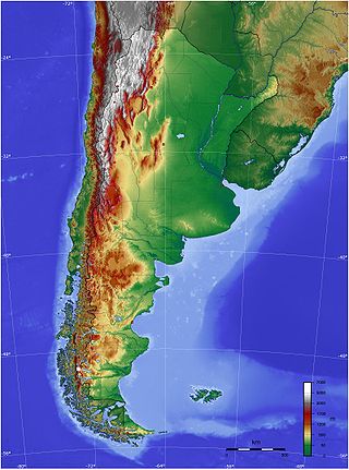
The geography of Argentina describes the geographic features of Argentina, a country located in the Southern Cone of South America. Bordered by the Andes in the west and the South Atlantic Ocean to the east, its neighbouring countries are Chile to the west, Bolivia and Paraguay to the north, and Brazil and Uruguay to the northeast.

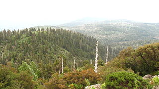
The Valdivian temperate forests (NT0404) is an ecoregion on the west coast of southern South America, in Chile and Argentina. It is part of the Neotropical realm. The forests are named after the city of Valdivia. The Valdivian temperate rainforests are characterized by their dense understories of bamboos, ferns, and for being mostly dominated by evergreen angiosperm trees with some deciduous specimens, though conifer trees are also common.

The Maule Region is one of Chile's 16 first order administrative divisions. Its capital is Talca. The region derives its name from the Maule River which, running westward from the Andes, bisects the region and spans a basin of about 20,600 km2. The Maule river is of considerable historic interest because, among other reasons, it marked the southern limits of the Inca Empire.

Laguna San Rafael National Park is a park located on the Pacific coast of southern Chile. The park is named for the San Rafael Lagoon formed by the retreat of the San Rafael Glacier. Created in 1959, it covers an area of 17,420 km2 (6,726 sq mi) and includes the Northern Patagonian Ice Field. A fjord more than 16 km (10 mi) long is one of the park's principal attractions.

Los Ruiles National Reserve is a small nature reserve located in Cauquenes Province of Maule Region in central Chile. The reserve consists of two sections that protect enclaves of native forest, which are home to several threatened and endangered species.

The protected areas of Chile are areas that have natural beauty or significant historical value protected by the government of Chile. These protected areas cover over 140,000 km2 (54,054 sq mi), which is 19% of the territory of Chile. The National System of Protected Wild Areas is regulated by law #18,362 passed in 1984, and administered by the National Forest Corporation (CONAF).

Villarrica National Park is located in the Andes, in the La Araucanía and Los Ríos regions of Chile, near Pucón. The centerpiece of the park is a line of three volcanoes stretching transversely to the Andean range: Villarrica, Quetrupillán, and Lanín. Other mountains in the park include Quinquilil volcano, also known as Colmillo del Diablo, and Cerro Las Peinetas, which lies on the border between Argentina and Chile. It ranges in elevation from 600 m (1,969 ft) to 3,776 m (12,388 ft) at Lanín Volcano.

Miñiques is a massive volcanic complex containing a large number of craters, lava domes and flows, located in the Antofagasta Region of Chile. Located 21 km (13 mi) south of Volcán Chiliques and 26 km (16 mi) west of Cordón Puntas Negras, it is part of a frequently visited attraction conformed by the high plain lagoons Laguna Miscanti, Laguna Miñiques and the Cerro Miscanti volcano.

Los Flamencos National Reserve is a nature reserve located in the commune of San Pedro de Atacama, Antofagasta Region of northern Chile. The reserve covers a total area of 740 square kilometres (290 sq mi) in the Central Andean dry puna ecoregion and consists of seven separate sections.

Valdivian Coastal Reserve is a natural reserve located in the Cordillera Pelada, in Los Ríos Region of Chile, near Corral.
Alerce Costero National Park is a protected wild area in the Cordillera Pelada about 137 km from Valdivia and 49 km from La Unión. Fitzroya trees grow inside the protected area and give the area its name, with Alerce Costero translating as Coastal Fitzroya. The Natural Monument has a total area of 137 hectares.

Bavispe is a small town and a municipality in the northeast part of the Mexican state of Sonora.

Palomo is a 4,860 metres (15,940 ft) high Chilean stratovolcano located in the commune of Machali, Cachapoal province, Libertador General Bernardo O'Higgins Region, west of Caldera del Atuel. Together with Tinguiririca it is one of two volcanoes in the region with evidence of Holocene volcanism. The volcano is remote and knowledge on its geology and potential volcanic hazards is limited.
Las Vicuñas National Reserve is a national reserve located in the Parinacota Province, Arica y Parinacota Region, Chile. The reserve lies immediately south of Lauca National Park and in its southern portion is contiguous to Salar de Surire Natural Monument, all of which form Lauca Biosphere Reserve. The major peaks are Arintika and Pukintika.
The Central American pine–oak forests is a tropical and subtropical coniferous forests ecoregion in the mountains of northern Central America and Chiapas state in southern Mexico.

Futaleufú is a Chilean town and commune located in Northern Patagonia. Located at the confluence of the Espolon and Futaleufú river valleys, the town is approximately 10 kilometers from the Argentinian border. Futaleufú is the provincial capital of Palena Province, Los Lagos Region. Futaleufú, known locally as “Futa,” is a frontier town with a growing tourism industry based on adventure tourism—most specifically whitewater rafting—but also fishing, mountain biking, trekking, and canyoning. Due to its proximity to the Argentinian border, Futaleufú is most easily accessed from airports in Esquel and Bariloche, Argentina. Other tourists access the town through the Northern Patagonia Airport in Chaiten, or vía a system of ferries that leave from the closest major Chilean city, Puerto Montt.
Hiking in Chile is characterized by a wide range of environments and climates for hikers, which largely results from Chile's unusual, ribbon-like shape, which is 4,300 kilometres long and on average 175 kilometres wide. These range from the world's driest desert, the Atacama, in the north, through a Mediterranean climate in the center, to the glaciers, fjords and lakes of Patagonia in the south.

Futaleufú National Reserve is a national reserve in the Northern Patagonia section of southern Chile. The park is administered by the CONAF. The Futaleufu National Reserve is located in Palena Province of Los Lagos Region of Chile, southeast of the Futaleufú River and the town of Futaleufu. The southern and eastern boundaries of the reserve are defined by the international border with Argentina. The park includes the headwaters of the Chico River, a scenic tributary of the more famous Futaleufu, and several waterfalls appear inside the park that can be accessed by hiking trails. The reserve also contains the most southern occurrence of Austrocedrus chilensis and is home to some South Andean deer.

Los Queules National Reserve is a national reserve of Chile. It covers an area of 1.47 km2 in the Chilean Coastal Range. The reserve ranges from 400 to 500 meters in elevation.

The Southern Andean steppe is a montane grasslands and shrublands ecoregion occurring along the border of Chile and Argentina in the high elevations of the southern Andes mountain range.


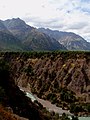 River and gorge running through the center of the reserve.
 Picnic area of the reserve.
