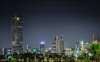
Addis Ababa is the capital and largest city of Ethiopia. In the 2007 census, the city's population was estimated to be 2,739,551 inhabitants. Addis Ababa is a highly developed and important cultural, artistic, financial and administrative centre of Ethiopia.
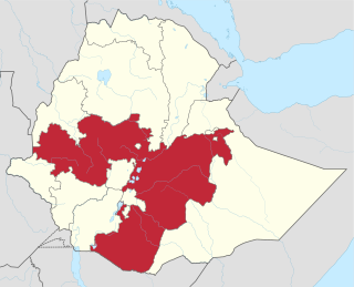
Oromia is a regional state in Ethiopia and the homeland of the Oromo people. Under Article 49 of Ethiopian Constitution, the capital of Oromia is Addis Ababa, also called Finfinne. The provision of the article maintains special interest of Oromia by utilizing social services and natural resources of Addis Ababa.
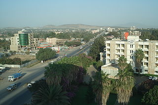
Adama, formerly Nazreth, is a one of the cities of Oromia Region of Ethiopia. Located in the East Shewa Zone 99 km (62 mi) southeast of the capital, Addis Ababa, the city sits between the base of an escarpment to the west, and the Great Rift Valley to the east.
Goba is a town and separate woreda located in the Bale Zone of the Oromia Region, Ethiopia approximately 446 km southeast of Addis Ababa, this city has a latitude and longitude of 7°0′N39°59′E and an elevation of 2,743 meters above sea level.
Metu is a market town and separate woreda in south-western Ethiopia. Located in the Illubabor Zone of the Oromia along the Sor River, this town has a latitude and longitude of 8°18′N35°35′E and an altitude of 1605 meters. Metu was the capital of the former Illubabor Province from 1978 until the adoption of the new constitution in 1995.

Ambo is a town in west-central Ethiopia. Located in the West Shewa Zone of Oromia Region, west of Addis Ababa, it is the capital city of West Shewa zone. This town has a latitude and longitude of 8°59′N37°51′E and an elevation of 2,101 meters.
Bishoftu is a town in central Ethiopia. Located in the East Shewa Zone of the Oromia Region, it sits at an elevation of 1,920 metres (6,300 ft). It was formerly known as Debre Zeyit. However, since the late 1990s, it has been officially known by the Oromo name, Bishoftu from bishaanooftuu, which was its name until 1955. The town serves as the primary airbase of the Ethiopian Air Force.
Nekemte, also spelled as Neqemte, is a market city and separate woreda in western Ethiopia. Located in the East Welega Zone of the Oromia Region, Nekemte has a latitude and longitude of 9°5′N36°33′E and an elevation of 2,088 meters.
Walmara is a district in the Oromia Special Zone Surrounding Finfinne, Oromia Region, Ethiopia. It is bordered on the south by the Sebeta Hawas, on the west by West Shewa Zone, on the north by Mulo, on the northeast by the Sululta, and on the east by the city of Addis Ababa. Towns in Walmara include Kolobo and Holeta.
Yubdo or Jubdo is a woreda in Oromia Region, Ethiopia. Part of the West Welega Zone, Yubdo is bordered on the south by Nole Kaba, on the west by Kelem Welega Zone, on the northwest by Ayra Guliso, on the northeast by Lalo Asabi, on the east by Gimbi, and on the southeast by Haru. The administrative center of this woreda is Yubdo; other towns in Yubdo include Ganji.
Akaki is a woreda or district in Oromia Region, Ethiopia. Part of the Oromia Special Zone Surrounding Finfinne, Akaki is bordered on the southwest by the Southwest Shewa Zone, on the west by Sebeta Hawas, on the northwest by Addis Ababa, on the north by the Bereh, and on the east by East Shewa Zone. The administrative center of this woreda is Dukem.

Waliso is a town in Southwest Shewa Zone of the Oromia Region in Ethiopia, 114 km southwest of Addis Ababa, it has a latitude and longitude of 8°32′N37°58′E with an elevation of 2063 meters above sea level. Waliso is the administrative center of this Zone.
Sendafa is a town and separate woreda in Oromia Region, Ethiopia. Its name is taken from the Oromo name for a kind of thick, jointed grass or reed which grows in swampy areas. Located in the Oromia Special Zone Surrounding Finfinne of the Oromia Region, Sendafa has a latitude and longitude of 9°09′N39°02′E with an elevation of 2514 meters above sea level. The town lies on the paved Addis Ababa - Adigrat highway, some 38 kilometers north of the capital.
Agaro is a town and separate woreda in south-western Ethiopia. Located in the Agaro zone of the Oromia Region, it sits at an elevation of 1,560 meters above sea level.
Robe, also called Bale Robe, is a town in south-central Oromia Region, Ethiopia. Located in the Bale Zone, this town has a latitude and longitude of 7°7′N40°0′E with an elevation of 2,492 metres (8,176 ft) above sea level.
Holeta is a town in the special zone of Oromia Region, Ethiopia. It has a latitude and longitude of 9°3′N38°30′E and an altitude of 2391 meters above sea level.
Gimbi (ጊምቢ) is a town in western Oromia Region, Ethiopia. Located in the West Welega Zone, it has a latitude and longitude of 9°10′N35°50′E with an elevation between 1845 and 1930 meters above sea level. It is the administrative center of Gimbi woreda.
Adola is a town located in the Guji Zone of the Oromia Region, at an altitude of 1,758 metres (5,768 ft) above sea level. 470 km from Addis Ababa.
Badessa is a town and separate Aanaa in eastern Ethiopia. Located in the West Hararghe Zone of the Oromia Region, at the base of a spur of the Chercher Mountains 40 km south of the Addis Ababa - Djibouti Railway and 65 km east of Awash, this town has a latitude and longitude of 8°54′N40°47′E with an elevation of 1761 m above sea level.
Burayu is a city and special census zone in the Oromia Region of Ethiopia, located directly adjacent to the national capital city Addis Ababa. With the rapid growth of the capital in recent decades and urban sprawl, the town has faced considerable economic and demographic pressures. The city's population has grown from merely 10,000 people in 1994 to an estimated 130,000 people three decades later; consisting of migrants from the rural south of Ethiopia looking for work along with former residents of Addis Ababa who sought cheaper housing in the surburbs.

