History
The town of Negele Borana was founded in the early 20th century; the Swedish doctor F. Hylander described it in 1934 as an "Amhara new settlement and fortress with palisades", which was "the farthest outpost towards Jubbaland". [2]
At the beginning of the Second Italo-Ethiopian War from 4 October 1935, Negele Borana served as the headquarters of Ras Desta Damtew. The Italians subjected the town to frequent bombing raids. [2] The Italians under General Rodolfo Graziani captured the town shortly after their victory at the Battle of Ganale Dorya, which further weakened the southern Ethiopian defenses. [6]
The town was occupied by the British Gold Coast Brigade on 27 March 1941, who had pushed north from Dolo. [7] The British colonial unit found that the Italians had abandoned the settlement 10 days before they arrived, and in the time between the buildings had been looted and destroyed by the neighboring Borena Oromo. [2] By the time David Buxton visited Negele Borana in 1943, he found that a battalion of the Ethiopian Army had garrisoned this "half-built Italian settlement". [8]
The Norwegian Lutheran Mission operated a station in Negele Borana from 1949. Their most important activity was to start a hospital for the town in one of the abandoned Italian buildings, which they operated until 1956 when the Ministry of Public Health took it over. In 1958, Negele Borana was one of 27 places in Ethiopia ranked as First Class Township. [2]
On 12 January 1974, enlisted men and non-commissioned officers of the Fourth Brigade stationed at the Military Base protested over their substandard living conditions. "There was nothing new about discontent among soldiers serving in the desolate conditions in these far-flung garrisons," note Marina and David Ottaway. "The heat was unbearable, the food barely edible, and the water was bad or in short supply". The last straw was when the officers refused to let the soldiers use their well after their own water pump broke down. The soldiers arrested their superior officers and petitioned Emperor Haile Selassie for redress of their grievances. The Emperor sent Lieutenant-General Deresse Dubale to investigate the matter; the mutineers took him prisoner, forced him to eat and drink as they did, then tied him up and put him under a tree for eight hours while they negotiated with the defense ministry. Furious, the Emperor sent two bombers to overfly the garrison and intimidate them to release Deresse, but did not punish the soldiers. The whole incident was hushed up for a while. [9]
During the Ogaden War, the Somali Army attempted to capture Negele Borana throughout August 1977, but the local garrison was able to beat back the attacks. [10]
Rights activists in southern Oromia reported to Human Rights Watch that students, farmers, and business people had been detained in Negele Borana. As of 25 January 2010 several hundred people, mostly affiliated with the Oromo People's Congress, were said to be still incarcerated in Negele borana jail. These arrests reportedly were in response to protests about the activities of mining companies in the region, which the authorities attributed to the opposition. [11]
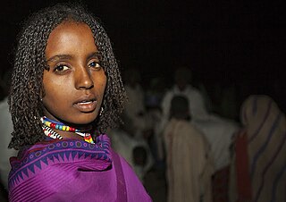
The Oromo people are a Cushitic ethnic group native to the Oromia region of Ethiopia and parts of Northern Kenya. They speak the Oromo language, which is part of the Cushitic branch of the Afroasiatic language family. They are one of the largest ethnic groups in Ethiopia. According to the last Ethiopian census of 2007, the Oromo numbered 25,488,344 people or 34.5% of the Ethiopian population. Recent estimates have the Oromo comprising 45,000,000 people, or 35.8% of the total Ethiopian population estimated at 116,000,000.
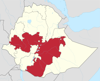
Oromia is a regional state in Ethiopia and the homeland of the Oromo people. Under Article 49 of Ethiopian Constitution, the capital of Oromia is Addis Ababa, also called Finfinne. The provision of the article maintains special interest of Oromia by utilizing social services and natural resources of Addis Ababa.

Moyale is a city on the border between Ethiopia and Kenya. In Ethiopia, Moyale is the administrative centre for two Ethiopian woredas, Moyale of the Oromia Region and Moyale of the Somali Region. In Kenya, it is the largest town of Marsabit County and the capital of Moyale sub-county.
Yabelo is a town in southern Ethiopia. An alternative name for this town is Obda, which is also the name of a nearby mountain. Located northwest of Moyale in the Borena Zone of the Oromia, this town has a latitude and longitude of 4°53′N38°5′E and an elevation of 1857 meters above sea level. It has been the administrative center of the Borena Zone since its division from Guji Zone in September 2002, as well as Yabelo woreda.

Ambo is a town in west-central Ethiopia. Located in the West Shewa Zone of Oromia Region, west of Addis Ababa, it is the capital city of West Shewa zone. This town has a latitude and longitude of 8°59′N37°51′E and an elevation of 2,101 meters.

Dembidollo, also spelled Dembi Dolo, is a market town and separate woreda in south-western Ethiopia. It is the capital of Kelam Welega Zone of the Oromia Region. This town, which is at an elevation of between 1,701 m (5,581 ft) and 1,827 m (5,994 ft) above sea level, was originally known as Sayo.
Nekemte, also spelled as Neqemte, is a market city and separate woreda in western Ethiopia. Located in the East Welega Zone of the Oromia Region, Nekemte has a latitude and longitude of 9°5′N36°33′E and an elevation of 2,088 meters.

Borena is a zone in Oromia Region of Ethiopia. Borena is named after one of the two major subgroups of the Oromo People. Borena is bordered on the south by Kenya, on the west by the Southern Nations, Nationalities, and Peoples Region, on the north by West Guji and Guji and on the east by Dawa Zone Somali Region. The highest point in this zone is Mount Dara Tiniro. Cities and major towns in this Zone include Negele Borana, Moyale, Yabelo, Dubuluk, Mega, Millami, Surupa and Bakke.
Mieso is a woreda in Oromia Region, Ethiopia. Part of the West Hararghe Zone, Mieso is bordered on the south by Guba Koricha, on the west by the Afar Region, on the north by the Somali Region, on the east by Doba and on the southeast by Chiro. The administrative center for this woreda is Mieso; other towns in Mieso include Asebot, Kora, Bordode and Gololcha.
Bore is one of the Aanaas in the Oromia of Ethiopia. Part of the Guji Zone, Bore is bordered on the south by Ana Sora, on the west by the Uraga, and on the north and east by the Southern Nations, Nationalities, and Peoples Region. The largest town in Bore is Bore.
Odo Shakiso is one of the Aanaas in the Oromia of Ethiopia. Part of the Guji Zone, Odo Shakiso is bordered on the south by the Dawa River which separates it from Arero, on the west by Bule Hora, on the northeast by Uraga, on the north by Bore, on the northeast by Adolana Wadera, and on the east by Liben. Towns in Odo Shakiso include Shakiso and Megado.
Liben is one of the woredas in the Oromia Region of Ethiopia. Part of the East Borana Zone, Liben is bordered on the west by Goro Dola, on the south by Gumi Eldalo, on the north by the Ganale Dorya River which separates it from Meda Welabu, and on the east by the Somali Region. Liben woreda surrounds the town of Negele Borana, which was separated from Liben.
Dire is one of the Aanaas in the Oromia of Ethiopia. Miyu was separated from Dire woreda. Located in the southern part of the Borena Zone, Dire is bordered on the south by Kenya, on the west by Teltele, on the north by Yabelo, on the northeast by Arero, and on the east by Moyale. Towns in Dire include Mega and Dubuluk.
Abaya is a woreda in the Oromia Region, Ethiopia. It is part of former Gelana Abaya woreda what was divided for Abaya and Gelana woredas. Part of the Borena Zone, Gelana Abaya was bordered on the south by Hagere Mariam, and on the west, north and east by the Southern Nations, Nationalities, and Peoples Region (SNNPR). Lake Abaya, on the western border, is divided between this woreda and the SNNPR. However, the Guji Oromo who live in Nechisar National Park are claimed to be administratively part of this woreda, in a kebele called "Irgansaa".
Mega is a town in southern Ethiopia. Located between Moyale and Yabelo on the paved highway south to Kenya, in the Borena Zone of the Oromia, this town has a latitude and longitude of 4°01′N38°15′E with an elevation of 1740 meters above sea level. Named for a nearby mountain, this town is the administrative center of Dire woreda.
Adola is a town located in the Guji Zone of the Oromia Region, at an altitude of 1,758 metres (5,768 ft) above sea level. 470 km from Addis Ababa.
Guji is a zone in Oromia Region of Ethiopia. Guji is named after a tribe of the Oromo people. Guji is bordered on the south by Borena, on the west by the Southern Nations, Nationalities, and Peoples Region, on the north by the Ganale Dorya River which separates it from Bale and on the east by the Somali Region. The highest point in this zone is Mount Dara Tiniro. Cities and major towns in this Zone include its administrative center, Nagele, Shakiso Bore, Dila Adola.
Filtu is the capital city of '"Liben Zone"' Filtu is a town in southern Ethiopia. Located in the Liben Zone of the Somali Region, it has a latitude and longitude of 4°58′N40°23′E with an elevation of 1252 meters above sea level. It is the administrative center of Filtu woreda. During the Italian occupation, a road 115 kilometers in length to Negele Boran was maintained but not paved.
The Gedeo are an ethnic group in southern Ethiopia. The Gedeo Zone in the Southern Nations, Nationalities, and People's Region (SNNPR) is named for this people. They speak the Gedeo language, which is one of the Cushitic languages.
Bati is a town in north-central Ethiopia. Located in the Oromia Zone of the Amhara Region, east of Dessie this town has a latitude and longitude of 11°11′N40°1′E with an elevation of 1502 metres above sea level. It is the largest town in Bati woreda.

