Nekemte

Last updated • 6 min readFrom Wikipedia, The Free Encyclopedia
Nekemte
Naqamtee
City
Nekemte.jpg
Nekemte city.jpg
Nekemte city 01.jpg
Ethiopia adm location map.svg
Red pog.svg
Nekemte
Location within Ethiopia
Africa location map.svg
Red pog.svg
Nekemte
Nekemte (Africa)
Coordinates: 9°5′N36°33′E / 9.083°N 36.550°E / 9.083; 36.550
Country Flag of Ethiopia.svg  Ethiopia
Region Flag of the Oromia Region.svg  Oromia
Zone East Welega
Elevation
2,088 m (6,850 ft)
Population
 (2007) [1]
  Total75,219
  Estimate 
(2021) [2]
148,613
Time zone UTC+3 (EAT)
Climate Cwb

Nekemte, also spelled as Neqemte (Oromo : Naqamtee, Amharic: ነቀምት), is a market city and separate woreda in western Ethiopia. Located in the East Welega Zone of the Oromia Region, Nekemte has a latitude and longitude of 9°5′N36°33′E / 9.083°N 36.550°E / 9.083; 36.550 and an elevation of 2,088 meters.

Contents

Nekemte was the capital of the former East Welega, and is home to a museum of Machaa Oromo culture. It is a burial place of Onesimos Nesib, a famous Oromo who translated the Bible to Oromo Language for the first time, in collaboration with Aster Ganno. It is also the seat of an Apostolic Vicariate of the Roman Catholic Church. [3] Nekemte is host to Wollega University. [4] It is served by an airport that is not currently open to commercial flights.

Nekemte is at the center of the road network for south-western Ethiopia. The first major road dates to the early 1930s, with a road that extended from the capital Addis Ababa west through Addis Alem, although the road was passable only by lorries for the 255 kilometers between Addis Alem and Nekemte. [5] Pankhurst later notes in his book that this road had five toll-gates. [6] A road connecting Nekemte to Gimbi, 110 kilometers in length, was part of the first stage of the Third Highway Program in 1963. Postal service for this city has been present as early as 1923. A branch of the Ethiopian Electric Light and Power Authority began providing electricity to the city by 1960. By 1957, phone service extended to the city. [3]

History

Nekemte like most of the towns of the Welega Province grew as a result of the rise of agricultural surplus after the Oromo became permanently settled in the early in the late 16th-century. Its rise was also closely connected with the rise of the Oromo institution of Gadaa, a system where every 8 years leadership in the community was transferred to a new age class of leaders. [7]

Nekemte was formerly overshadowed by nearby Lieka and Bilo, the former regional markets. Nekemte acquired some importance when Bekere Godana in 1841 extended his rule of Nekemte over more area to form a new polity. [7] and later his son Moroda Bekere made it the capital of their kingdom of Welega in the mid-19th century. Under Mereda's son Kumsa Moroda (Gebregziabher Moroda after converting to Christianity), the city continued in its importance as it submitted to Shewan rule. The Russian explorer Alexander Bulatovich visited Nekemte 13 March 1897; in memoirs he describes its marketplace as "a very lively place and presents a motley mixture of languages, dress, and peoples", and carefully described the paintings in the city's newly constructed Ethiopian Orthodox church. [8] In 1905, a central government customs office was officially opened in Nekemte. Construction on a hospital began in 1927, and was completed in 1932 with Swedish funds as well as contributions from Ras Tafari (who later became Emperor Haile Selassie). It formally opened 16 February 1932, although it had already been in operation for eight months. [3]

By 1935 Nekemte had become the most important town in Welega. There were nearly 70 foreign residents before the Italian occupation, mostly merchants and missionaries. 23 importers-exporters had agencies there, most of whom were Indians, but these also included two Greeks, a Lebanese, and an Armenian. [9] The British explorer Dunlop, who spent four days of the same year in that city, noted that its central location on the main trade route between Addis Ababa and the Anglo-Sudan led to it having "developed enormously during the preceding few years, as the new school, warehouses, stores, and hospital testified". [10]

During the Italian invasion, Nekemte was bombed by the Italians 5 July 1936; this included dropping 19 bombs on the recently constructed school complex of the local Swedish mission. Dejazmach Habte Maryam, governor of Welega, accepted the Italians and received Colonel A. Marone who arrived by air on 14 October and the troops of Colonel Malta who reached the city on 24 October, after having marched by foot and mule for twelve days from Addis Alem, which weakened Ras Imru Haile Selassie's attempts as Prince Regent to establish a center of resistance at Gore. After his successful return to Ethiopia, on 20 May 1941 Emperor Haile Selassie visited Welega where fighting still continued and where Kebede Tesemma was in charge of the Arbegnoch . When he attempted to visit Nekemte, his party came under artillery fire. [3]

A public address system was installed in the central square in Nekemte (and in ten other towns) in 1955, used for receiving transmission from Radio Addis Ababa and re-broadcasting it. In 1957 Haile Sellasie I School was opened, one of nine provincial secondary schools in Ethiopia and outside Eritrea. At that time Nekemte was still the end point of the telephone line westward. The Tafari Makonnen Leprosarium (founded that year) also had a home-school for children of leprous parents. [3]

Head of State Mengistu Haile Mariam visited Nekemte during a formal tour in March–May 1979. In that same year, over 300 Evangelical Christians had been imprisoned for political reasons. [3]

Early in 1991, the Ethiopian Fourth Revolutionary Army had its headquarters at Nekemte. The Ethiopian People's Revolutionary Democratic Front captured Nekemte on 2 April 1991, as part of Operation Freedom and Equality (Duula Bilisummaa fi Walqixxummaa). In response, the Oromo Liberation Front (OLF) said in a broadcast on the Radio Voice of Oromo Liberation (Frankfurt am Main) on 15 April 1991: "The OLF strongly opposes the phrase: liberating Wellega or the Oromo nation. It is false for any alien force to say that it will liberate the Oromo nation." [3]

After the Ethiopian trade mission in the Somaliland city of Hargeisa was hit by a suicide bomb attack, which killed at least four Ethiopian civilian lives on 29 October 2008, three human rights activists working for the Ethiopian Human Rights Council in Nekemte were arrested, but were released by 27 November. [11]

Climate

The city has a mild highland subtropical climate (Köppen: Cwb). With a lower elevation than Addis Ababa, Nekemte has a slightly higher average temperature, differing mainly in the low averages. The average annual temperature is 18.3 °C (high: 24 °C and low: 12.6 °C), although to the north of Equator March is the warmest month and July the coldest month. With more than 2080 mm, it is one of the rainiest places in the country, with most of that rain occurring in the Summer. Nekemte is on an imaginary line where western winds give way to eastern ones. [12] [13] It is one of the seven rainiest cities in the country. [14] From about 2007 to 2017, a nearby meteorological station showed an average annual temperature that, though lower than that from 1990, was still higher than 1970, when rigorous recordkeeping began there, as well as greater precipitation than that seen in the 1980s. [15]

Climate data for Nekemte, elevation 2,080 m (6,820 ft), (1971–2000)
MonthJanFebMarAprMayJunJulAugSepOctNovDecYear
Mean daily maximum °C (°F)25.8
(78.4)
26.7
(80.1)
27.0
(80.6)
26.7
(80.1)
24.4
(75.9)
21.7
(71.1)
20.7
(69.3)
20.7
(69.3)
21.9
(71.4)
23.2
(73.8)
24.2
(75.6)
24.8
(76.6)
24.0
(75.2)
Mean daily minimum °C (°F)11.7
(53.1)
12.3
(54.1)
13.0
(55.4)
13.4
(56.1)
12.8
(55.0)
11.5
(52.7)
11.2
(52.2)
11.0
(51.8)
10.6
(51.1)
11.4
(52.5)
12.0
(53.6)
11.7
(53.1)
11.9
(53.4)
Average precipitation mm (inches)8.0
(0.31)
16.0
(0.63)
60.0
(2.36)
85.0
(3.35)
233.0
(9.17)
380.0
(14.96)
422.0
(16.61)
367.0
(14.45)
294.0
(11.57)
142.0
(5.59)
60.0
(2.36)
22.0
(0.87)
2,089
(82.23)
Average relative humidity (%)46435246587581817162565060
Source: FAO [16]

Education

Demographics

The 2007 national census reported a total population for this woreda of 75,219, of whom 38,385 were men and 36,834 were women. A plurality of its inhabitants were Protestant, with 48.49% of the population reporting they observed this belief, while 39.33% of the population said they observed Ethiopian Orthodox Christianity, and 10.88% were Moslem. [17]

The 1994 census reported this city had a total population of 47,258 of whom 22,844 were males and 24,414 were females. Nekemte is the largest city in Guto Wayu woreda. [18]

Sports

Association football is the main sport in Nekemte. The Welega Stadium, which has a capacity of 50,000, is the largest sports venue by capacity in Nekemte. It opened in 2019 and the stadium is also mainly used for football, and also for athletics.

See also

Related Research Articles

<span class="mw-page-title-main">Addis Ababa</span> Capital and largest city of Ethiopia

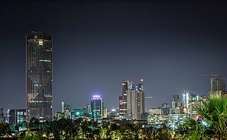
Addis Ababa is the capital and largest city of Ethiopia. In the 2007 census, the city's population was estimated to be 2,739,551 inhabitants. Addis Ababa is a highly developed and important cultural, artistic, financial and administrative center of Ethiopia. It is widely known as one of Africa's major capitals.

<span class="mw-page-title-main">Oromia</span> Regional state of Ethiopia

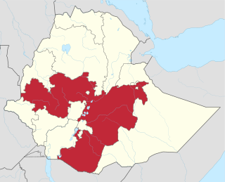
Oromia is a regional state in Ethiopia and the homeland of the Oromo people. Under Article 49 of Ethiopian Constitution, the capital of Oromia is Addis Ababa, also called Finfinne. The provision of the article maintains special interest of Oromia by utilizing social services and natural resources of Addis Ababa.

Bonga is a town, woreda and one of the multicapital of the South West Ethiopia Peoples' Region in Ethiopia. Located in the Keffa Zone upon a hill in the upper Barta valley, it has a latitude and longitude of 7°16′N36°14′E with an elevation of 1,714 meters above sea level. Not confused with another town named "Bonga", near Gambela Region.

Metu is a market town and separate woreda in south-western Ethiopia. Located in the Illubabor Zone of the Oromia along the Sor River, this town has a latitude and longitude of 8°18′N35°35′E and an altitude of 1605 meters. Metu was the capital of the former Illubabor Province from 1978 until the adoption of the new constitution in 1995.

Addis Alem is a town in central Ethiopia. Located in the West Shewa Zone of the Oromia Region, west of Addis Ababa, this town has a latitude and longitude of 9°2′N38°24′E with an elevation of about 2360 meters above sea level.

<span class="mw-page-title-main">Ambo, Ethiopia</span> Town in Oromia Region, Ethiopia

Ambo is a town in west-central Ethiopia. Located in the West Shewa Zone of Oromia Region, west of Addis Ababa, it is the capital city of West Shewa zone. This town has a latitude and longitude of 8°59′N37°51′E and an elevation of 2,101 meters.

<span class="mw-page-title-main">Dembidolo</span> Town in Oromia Region, Ethiopia

Dembidollo, also spelled Dembi Dolo, is a market town and separate woreda in south-western Ethiopia. It is the capital of Kelam Welega Zone of the Oromia Region. This town, which is at an elevation of between 1,701 m (5,581 ft) and 1,827 m (5,994 ft) above sea level, was originally known as Sayo.

Erer is a woreda in Somali Region, Ethiopia. Part of the Shinile Zone, Erer is bordered on the south by Dire Dawa and Oromia Region, on the southwest by Afdem, on the northwest by the Afar Region, and on the east by Shinile.

Cheliya is one of the Aanaas in the Oromia of Ethiopia. Part of the West Shewa Zone, Cheliya is bordered on the south by Nono and Dano, on the southwest by the Gibe River which separates it from the Jimma Zone, on the west by Bako Tibe, on the northwest by the Guder River which separates it from the Horo Gudru Welega Zone, on the north by Ginde Beret, on the northeast by Jeldu, on the east by Ambo, and on the southeast by Tikur. The administrative center of this Aanaa is Gedo; other towns in Cheliya include Babiche, Ejaji, and Hamus Gebeya. Midakegn woreda was separated form Cheliya.

Bako Tibe is one of the Aanaas, or districts, in the Oromia region of Ethiopia. Part of the West Shewa Zone, Bako Tibe is bordered on the south and west by the East Welega Zone, on the north by Horo Gudru Welega Zone, and on the east by Cheliya. The administrative center of this woreda is Bako; other towns in Bako Tibe include Tibe and Shoboka.

Yubdo or Jubdo is a woreda in Oromia Region, Ethiopia. Part of the West Welega Zone, Yubdo is bordered on the south by Nole Kaba, on the west by Kelem Welega Zone, on the northwest by Ayra Guliso, on the northeast by Lalo Asabi, on the east by Gimbi, and on the southeast by Haru. The administrative center of this woreda is Yubdo; other towns in Yubdo include Ganji.

Sibuu Siree is one of woredas in the Oromia Region of Ethiopia. Part of the Misraq (East) Welega Zone, Sibu Sire is bordered on the south by Wama Bonaya, on the west by Guto Wayu, and on the north and east by Bila Seyo. The administrative center of this woreda is Sire.

Dire is one of the Aanaas in the Oromia of Ethiopia. Miyu was separated from Dire woreda. Located in the southern part of the Borena Zone, Dire is bordered on the south by Kenya, on the west by Teltele, on the north by Yabelo, on the northeast by Arero, and on the east by Moyale. Towns in Dire include Mega and Dubuluk.

Holeta is a town in the special zone of Oromia Region, Ethiopia. It has a latitude and longitude of 9°3′N38°30′E and an altitude of 2391 meters above sea level.

Gimbi (ጊምቢ) is a town in western Oromia Region, Ethiopia. Located in the West Welega Zone, it has a latitude and longitude of 9°10′N35°50′E with an elevation between 1845 and 1930 meters above sea level. It is the administrative center of Gimbi woreda.

<span class="mw-page-title-main">Mojo, Ethiopia</span> Town in Oromia Region, Ethiopia

Mojo is a town in central Ethiopia, named after the nearby Modjo River. Located in the East Shewa Zone of the Oromia Region, it has a latitude and longitude of 8°39′N39°5′E with an elevation between 1788 and 1825 meters above sea level. It is the administrative center of Lome district.

<span class="mw-page-title-main">Kelam Welega Zone</span>

Kellem Wollega is one of the zones of the Oromia Region in Ethiopia. This zone is named after the former province of Wollega, whose western part lay in the area Kellem Wollega now occupies. Kellem Wollega was formed of woredas which included to West Wollega Zone.

<span class="mw-page-title-main">Oromo Liberation Army</span> Armed movement in Ethiopia

The Oromo Liberation Army is an armed opposition group active in the Oromia Region of Ethiopia. The OLA consist primarily of former armed members of the pre-peace deal Oromo Liberation Front (OLF) who refused to disarm out of skepticism of the peace deal, and former youth protestors who grew disillusioned with nonviolent resistance.

Baro Tumsa (1938–1978) was a pharmacist, lawyer and Oromo nationalist and political activist in Ethiopia. He was the younger brother of Reverend Gudina Tumsa and later joined the Oromo Liberation Front after being expelled from Finfinne by The Dergue.

<span class="mw-page-title-main">OLA insurgency</span> Internal conflict in Ethiopia since 2018

The OLA insurgency is an armed conflict between the Oromo Liberation Army (OLA), which split from the Oromo Liberation Front (OLF) in 2018, and the Ethiopian government, continuing in the context of the long-term Oromo conflict, typically dated to have started with the formation of the Oromo Liberation Front in 1973.

References

  1. "Population and Housing Census 2007 – Oromia Statistical" (PDF). Ethiopian Statistics Service. 2007. Retrieved 31 May 2022.
  2. "Population Projection Towns as of July 2021" (PDF). Ethiopian Statistics Agency. 2021. Retrieved 31 May 2022.
  3. 1 2 3 4 5 6 7 "Local History in Ethiopia" [ permanent dead link ] (pdf) The Nordic Africa Institute website (accessed 27 January 2008)
  4. "Wollega university official website". Archived from the original on 2012-02-13. Retrieved 2012-02-14.
  5. Pankhurst 1968, p. 293.
  6. Pankhurst 1968, p. 522.
  7. 1 2 Ta'a, Tesema (1993). "The Process of Urbanization in Wollega, Western Ethiopia: the Case of Neqemte". Journal of Ethiopian Studies. 26 (1): 59–72. JSTOR   41966012.
  8. From Entotto to the River Baro Archived 2017-12-16 at the Wayback Machine (1897), translated by Richard Selzer, Ethiopia through Russian Eyes: Country in Transition, 1896-1898 (Lawrenceville: Red Sea Press, 2000) ISBN   1-56902-117-1 (accessed 2 November 2009)
  9. Pankhurst 1968, p. 450.
  10. Dunlop, A. (1937). "The Dadessa Valley". The Geographical Journal. 89 (6): 507–521. doi:10.2307/1787909. JSTOR   1787909.
  11. "Ethiopia: Charge or Free Ethnic Oromo Terrorism Suspects", Human Rights Watch website, 27 November 2009 (accessed 17 March 2009)
  12. "Nekemte climate: Average Temperature, weather by month, Nekemte weather averages - Climate-Data.org". en.climate-data.org. Retrieved 2019-02-15.
  13. Fazzini, Massimiliano; Bisci, Carlo; Billi, Paolo (2015). "The Climate of Ethiopia". Landscapes and Landforms of Ethiopia. World Geomorphological Landscapes. pp. 65–87. doi:10.1007/978-94-017-8026-1_3. ISBN   978-94-017-8025-4.
  14. Lemma, Melesse (2013-04-15). "Climate Data observation, climate monitoring and long range forecast methods in Ethiopia" (PDF). National Meteorological Agency of Ethiopia. Archived from the original (PDF) on 3 May 2017. Retrieved 2019-02-15.
  15. Abebe, Gezahegn (October 2017). "Long-term climate data description in Ethiopia". Data in Brief. 14: 371–392. doi:10.1016/j.dib.2017.07.052. PMC   5552378 . PMID   28831403.
  16. "CLIMWAT climatic database". Food and Agriculture Organization of United Nations. Retrieved 21 June 2024.
  17. 2007 Population and Housing Census of Ethiopia: Results for Oromia Region, Vol. 1, Tables 2.1, 2.5, 3.4 (accessed 13 January 2012)
  18. "Population and Housing Census 1994 – Oromia Region" (PDF). Ethiopian Statistics Agency. 1994. Retrieved 1 June 2022.

Sources

Further reading

9°5′N36°33′E / 9.083°N 36.550°E / 9.083; 36.550