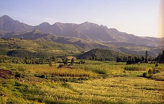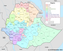
Illubabor is a zone in Oromia Region of Ethiopia. Illubabora is named for the former province Illubabor. It is bordered on the south by the Southern Nations, Nationalities and Peoples Region, on the southwest by the Gambela Region, on the west by Kelem Welega Zone, on the north by West Welega Zone, and Benishangul-Gumuz Region, on the northwest by East Welega Zone, and on the east by Jimma. Towns and cities in Illubabora include Bedele, Gore and Metu.

Borena is a zone in Oromia Region of Ethiopia. Borena is named after one of the two major subgroups of the Oromo People. Borena is bordered on the south by Kenya, on the west by the Southern Nations, Nationalities, and Peoples Region, on the north by West Guji and Guji and on the east by Dawa Zone Somali Region. The highest point in this zone is Mount Dara Tiniro. Cities and major towns in this Zone include Negele Borana, Moyale, Yabelo, Dubuluk, Mega, Millami, Surupa and Bakke.

North Shewa is a zone in the Amhara Region of Ethiopia. North Shewa takes its name from the kingdom and former province of Shewa. The Zone is bordered on the south and the west by the Oromia Region, on the north by South Wollo, on the northeast by the Oromia Zone, and on the east by the Afar Region. The highest point in the Zone is Mount Abuye Meda, which is found in the Gish woreda; other prominent peaks include Mount Megezez. Towns in North Shewa include Ankober, Debre Birhan, and Shewa Robit.

The Oromia Zone is a zone in Amhara Region of Ethiopia. Oromia is named for the Oromo people, who settled along the edge of the Ethiopian Highlands that form this Zone. Oromia Zone is bordered on the southwest by North Shewa Zone, on the northwest by South Wollo and Argobba special woreda, and on the east by the Afar Region. The Zone consists of 7 Woredas which are Artuma Fursi, Bati, Bati Town, Dewa Cheffa, Dewa Harewa, Jilye Tumuga and Kemisie town. Kemise is the administrative center of the Zone.

Jimma is a zone in Oromia Region of Ethiopia. Jimma is named after former Kingdom of Jimma, which was absorbed into the former province of Kaffa in 1932. Jimma is bordered on the south by the Southern Nations, Nationalities and Peoples Region, the northwest by Illubabor Zone, on the north by East Welega Zone and on the northeast by West Shewa Zone; part of the boundary with West Shewa Zone is defined by the Gibe River. The highest point in this zone is Mount Maigudo. Towns and cities in Jimma include Agaro, Limmu Inariya and Saqqa. The town of Jimma was separated from Jimma Zone and is a special zone now.

Bale Zone is a zone in Oromia Region of Ethiopia. Bale is bordered on the south by the Ganale Dorya River which separates it from Guji Zone, on the west by the West Arsi Zone, on the north by Arsi Zone, on the northeast by the Shebelle River which separates it from West Hararghe Zone and East Hararghe Zone, and on the east by the Somali Region.

West Shewa Zone is a zone in Oromia Region of Ethiopia. This zone takes its name from the kingdom or former province of Shewa. West Shewa is bordered on the south by the Southwest Shewa Zone and the Southern Nations, Nationalities and Peoples Region, on the southwest by Jimma, on the west by East Welega Zone, on the northwest by Horo Gudru Welega Zone, on the north by the Amhara Region, on the northeast by North Shewa, and on the east by Oromia Special Zone Surrounding Addis Abeba. Its highest point is Mount Wenchi ; other notable peaks include Mount Mengesha and Mount Wechacha. Towns and cities in West Shewa include Ambo.

East Welega is one of the zones in the central Oromia Region of Ethiopia. This administrative division acquired its name from the former province of Welega. Towns and cities in this zone include Nekemte.

West Welega Zone is a zone in the western part of Oromia Region, Ethiopia. This zone is named after the former province of Welega, whose western part lay in the area West Welega now occupies.

West Hararge is a zone in the Oromia Region of Ethiopia. West Hararghe takes its name from the former province of Hararghe. West Harerge is bordered on the south by the Shebelle River which separates it from Bale, on the southwest by Arsi, on the northwest by the Afar Region, on the north by the Somali Region and on the east by East Hararghe. Towns in West Hararghe include Chiro, Badessa, Gelemso, and Mieso, Asebot.

East Hararghe is a zone in the Oromia Region of Ethiopia. East Hararghe Zone is bordered on the southwest by Bale, on the west by West Hararghe Zone, on the north by Dire Dawa and on the north and east by the Somali Region. The Harari Region is an enclave inside this zone.

North Shewa is a zone in Oromia Region of Ethiopia. North Shewa takes its name from the kingdom of Shewa or former province of Shewa. North Shewa is bordered on the south by Addis Ababa on the southwest by West Shewa, on the north by the Amhara Region, and on the southeast by East Shewa. Town include Ali Doro, Fiche and Gerba Guracha, Sheno.
Nono Sele is one of the woredas in the Oromia Region of Ethiopia. It is named after the Nono Oromo, a subgroup of the Macha Oromo, who live in this area. Part of the Illubabor Zone, Nono Sele is bordered on the southwest by the Gambela Region, on the north by Bure, on the northeast by Ale, and on the southeast by the Southern Nations, Nationalities and Peoples Region. Towns in Nono Sele include Birbirsa and Nono.
Jarso is a woreda in Oromia Region, Ethiopia. Part of the West Welega Zone, Jarso is bordered on the south by Ayra Guliso, on the southwest by Gawo Dale, on the west by Begi, on the north by Mana Sibu, on the northeast by Nejo, and on the southeast by Boji. Towns in Jarso include Dabeka and Geba Dafino.
Daru labu is a woreda in the Oromia Region of Ethiopia. Located in the West Hararghe Zone, Daru labu is bordered on the south by the Shebelle River which separates it from the Bale Zone, on the west by the Arsi Zone, on the northwest by Guba Koricha, on the north by the Habro, and on the east by Boke. Towns in Darolebu include Mechara and Micheta.
Boke is one of the Aanaas in Oromia Regional State, Ethiopia. Part of the West Hararghe Zone, Boke is bordered on the south by the Shabelle River which separates it from the Bale Zone, on the southwest by Darolebu, on the northwest by Habro, on the northeast by Kuni, and on the east by the Galetti River which separates it from the East Hararghe Zone. The major town in Boke is Boke Tiko.

Sululta is a town and woreda in Oromia Region, Ethiopia. It was part of former Mulona Sululta woreda which was separated for Mulo and Sululta woredas. Part of the Oromia Special Zone Surrounding Finfinne, Sululta is bordered to the south by the city of Addis Ababa, to the west by the Mulo and West Shewa Zone, to the north by North Shewa Zone, and to the east by Bereh. Towns in Sululta include Chancho, Durba, Muger Sheleko, Rob Gebeya, Sululta and Segno Gebeya.

Guji is a zone in Oromia Region of Ethiopia. Guji is named after a tribe of the Oromo people. Guji is bordered on the south by Borena, on the west by the Southern Nations, Nationalities, and Peoples Region, on the north by the Ganale Dorya River which separates it from Bale and on the east by the Somali Region. The highest point in this zone is Mount Dara Tiniro. Cities and major towns in this Zone include its administrative center, Nagele, Shakiso Bore, Dila Adola.

West Arsi is a zone in the Oromia Region of Ethiopia. This zone is named after a subgroup of the Oromo, who inhabit it. It covers an area of 11,776.72 km2, divided into 12 districts (weredas). The population was officially estimated at 2,929,894 in mid 2022. The administrative center of this zone is Shashamane, with an estimated 208,368 inhabitants in mid 2022; other towns in this zone include Arsi Negele (98,114) in Arsi Negele District, Dodola (43,186) in Dodola District, Asassa (42,867) in Gedeb Asasa District, Kofele (27,948) in Kofele District, and Adaba (25,098) in Adaba District.
Bati is a district in the Oromia Zone of the Amhara region of Ethiopia. Bati is bordered on the south by Dawa Harewa, on the southeast by the Argobba special woreda, on the west and north by the Debub Wollo Zone, and on the east by the Afar Region. Towns in this woreda include its administrative center, the market town of Bati. The towns of Degan and Gerba were administratively part of Bati before the 2007 census but was then transferred to Kalu woreda.


