Demographics
The 2007 national census reported this woreda's population as 129,000, of whom 64,516 were men and 64,484 women; 15,145 or 11.74% of its population were urban dwellers. The majority of the inhabitants said they practised Ethiopian Orthodox Christianity, with 94.34% of the population reporting they practiced that belief, 2.76% were Protestant, and 2.07% were Muslim. [6]
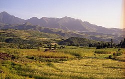
Based on figures published by the Central Statistical Agency in 2005, Mulona Sululta had an estimated total population of 188,124, of whom 95,156 were men and 92,968 women; 17,748 or 9.43% of its population were urban dwellers, which is about the same as the Zone average of 9.5%. With an estimated area of 1,520.32 square kilometers, Mulona Sululta had an estimated population density of 123.7 people per square kilometer, which is less than the Zone average of 143. [7]
The 1994 national census reported a total population for this woreda of 133,950, of whom 66,523 were men and 67,427 women; 9,944 or 7.42%% of its population were urban dwellers at the time. The two largest ethnic groups reported in Mulona Sululta were the Oromo (93.59%), and the Amhara (5.73%); all other ethnic groups made up 0.22% of the population. Oromo was spoken as a first language by 94.8%, and 4.82% spoke Amharic; the remaining 0.68% spoke all other primary languages reported. The majority of the inhabitants professed Ethiopian Orthodox Christianity, with 98.17% of the population reporting they practiced that belief, while 1.04% of the population said they observed traditional beliefs which was the largest group of this faith in the Zone. [8]
Gindabarat is one of the woredas in the Oromia Region of Ethiopia. The district is marginal within the central-highlands of Ethiopia, being isolated geographically by lowland gorges and rivers which physically separate it from all but one neighboring district, due to a poor road network. Part of the West Shewa Zone, Gindabarat is bordered on the south by Jeldu, on the southwest by Ambo, on the west by the Guder River which separates it from the Horo Guduru Welega Zone, on the north by the Abay River which separates it from the Amhara Region, on the east by the Muger River which separates it from the North Shewa Zone, and on the southeast by Meta Robi. The major town in Gindabarat is Kachise. Abuna Gindabarat woreda was separated from Gindabarat.
Meta Robi is one of the Aanaas in the Oromia region of Ethiopia. Part of the West Shewa Zone, it is bordered on the south by Ejerie, on the southwest by Jeldu, on the northwest by Ginde Beret, on the north by the Muger River, and on the east by Adda Berga. The major town in Meta Robi is Shino.
Adda Berga is a woreda in Oromia Region, Ethiopia. Part of the West Shewa Zone, Adda Berga is bordered on the south by Walmara, on the southwest by Ejerie, on the west by Meta Robi, and on the north and east by the Muger River which separates it from the north Shewa Zone. Towns in Adda Berga include Enchini, Muger and Reji.
Walmara is a district in the Oromia Special Zone Surrounding Finfinne, Oromia Region, Ethiopia. It is bordered on the south by the Sebeta Hawas, on the west by West Shewa Zone, on the north by Mulo, on the northeast by the Sululta, and on the east by the city of Addis Ababa. Towns in Walmara include Kolobo and Holeta.
Sebata Hawas, also spelled Sabbataa Awaas, is a woreda in Oromia Region, Ethiopia. Part of the Oromia Special Zone Surrounding Finfinne, Alem Gena is on the southwest by Southwest Shewa Zone, on the northwest by Walmara, on the north by Burayu, on the northeast by the city of Addis Ababa, and on the east by the Akaki. The Awash River defines this woreda's boundary with south west Shewa Zone. The towns in Sebeta Hawas include Sebeta Hawas (Town), Awash Melka, and Tefki. The town of Sebeta was separated from this district.
Tole is one of the woredas in Oromia Region, Ethiopia. Part of the Southwest Shewa Zone, it is bordered on the southwest by Kokir, on the west by Becho, on the northwest by Elu, on the northeast by the Awash which separates it from Alem Gena, and on the east and south by Kersana Kondaltiti. The major town in Tole is Bentu Liben.
Berek is a woreda or district in Oromia Region, Ethiopia. It was part of the former Berek Aleltu woreda which was separated for Aleltu and Berek woredas and Sendafa Town. Part of the Oromia Special Zone Surrounding Finfinne, Berek is bordered on the south by the Akaki and East Shewa Zone, on the southwest by the city of Addis Ababa, on the west by Sululta, on the north by North Shewa Zone, and on the east by the Amhara Region.
Wuchale is a woreda in Oromia Region, Ethiopia. It was part of former woreda of Wuchalena Jido which was separated for Jido and Wuchale woredas.. Part of the Kaba Shewa Zone, Wuchale is bordered on the south by Berehna Aleltu, on the west by Mulona Sululta, on the northwest by Yaya Gulele], on the northeast by the Amhara Region, on the east by Liban woreda, and on the southeast by Kembibit. Towns in Wuchale include Muka and Turi.
Wara Jarso is a woreda in the Oromia Region, Ethiopia. Part of the North Shewa Zone, Wara Jarso is bordered on the south by Kuyu, on the west by the Muger River which separates it from the [[West Shewa Zone]], on the north by the Abay River which separates it from the Amhara Region, on the northeast by the Jamma River which separates it from Dera, and on the east by Hidabu Abote. Towns in Wara Jarso include Filiklik, Gohatsion and Tullu Milki.
Dera is a woreda in Oromia Region, Ethiopia. Part of the Kaba Shewa Zone, Dera is bordered on the south by the Jamma River which separates it from Hidabu Abote and Wara Jarso, on the west, north and east by the Amhara Region; the Abay River defines the western boundary, and its tributary the Walaqa River the northern. The administrative center of Dera is Gundo Meskel.
Hidabu Abote is one of the Aanaas in the Oromia of Ethiopia. Part of the Kaba Shewa Zone, Hidabu Abote is bordered on the south by Kuyu, on the west by Wara Jarso, on the north by the Jamma River which separates it from Dera, and on the east by Degem. The major town in Hidabu Abote is Ejere Notable high points include Mount Ileu.
Degem is one of the Aanaas in North Shewa Zone of Oromiya in Ethiopia. Degem is bordered on the south by Muger River which separates it from East Welega Zone, on the west by Kuyu, on the northwest by Hidabu Abote, on the north by Jamma River which separates it from Amhara Region, on the northeast by Gerar Jarso, and on the east by Yaya Gulele. Towns in Degem include Alidoro and hambiso.
Yaya Gulele is a woreda in Oromia Region, Ethiopia. It was part of former Yaya Gulelena Tulluu Liban which was separated from Liban woreda and Yaya Gulele district. Part of the North Shewa Zone, Yaya Gulele is bordered on the south by Mulona Sululta, on the southwest by the Muger River which separates it from the West Shewa Zone, on the west by Degem, on the north by Gerar Jarso, on the north east by Liban woreda, and on the east by Wuchale. Towns in Yaya Gulele include Fital.
Kembibit is a woreda in Oromia Region, Ethiopia. Part of the Kaba Shewa Zone, Kembibit is bordered on the south by Berehna Aleltu, on the west by Wuchalena Jido, on the north by Abichuna Gne'a, and on the east by the Amhara Region. The administrative center of this woreda is Sheno; other towns in Kembibit include Hamus Gebeya and Kotu.
Sasiga is one of the woredas in the Oromia Region of Ethiopia and a part of the Misraq (East) Welega Zone. Sasiga is bordered on the south by Diga Leka, on the west by the Benishangul-Gumuz Region, on the northwest by Limmu, on the north by an exclave of the Benishangul-Gumuz Region and on the east by Guto Wayu. The administrative center of this woreda is Galo. Other towns in Sasiga include Handhura Balo, Bareda, Angar, Arb Gebeya, Ehud Gebeya, Gute and Tsige.
Akaki is a woreda or district in Oromia Region, Ethiopia. Part of the Oromia Special Zone Surrounding Finfinne, Akaki is bordered on the southwest by the Southwest Shewa Zone, on the west by Sebeta Hawas, on the northwest by Addis Ababa, on the north by the Bereh, and on the east by East Shewa Zone. The administrative center of this woreda is Dukem.
Nannawa Adama is a woreda in Oromia Region, Ethiopia. Part of the East Shewa Zone located in the Great Rift Valley, Adama Zuria is bordered on the south by the Arsi Zone, on the southwest by Koka Reservoir which separates it from Dugda Bora, on the west by Lome, on the north by the Amhara Region, and on the east by Boset; the Awash River, the only important river in this woreda, defines the woreda boundaries on the east and south. Other towns in this woreda include Awash Melkasa, Shewa Alemtena, Sire Robi, Sodere and Wenji Gefersa.
Gimbichu is a woreda in Oromia Region, Ethiopia. Part of the East Shewa Zone, Gimbichu is bordered on the south by Lome, on the southwest by Ada'a Chukala, on the northwest by the Amhara Region, and on the east by the Afar Region. The administrative center is Chefe Donsa.
Dugda is a district in the Oromia Region of Ethiopia. It was part of the former district of Dugda Bora before being divided into Bora and Dugda. Part of the East Shewa Zone located in the Great Rift Valley, Dugda is bordered on the southeast by Hora-Dambal, on the south by Adami Tullu and Jido Kombolcha, on the west by the Southern Nations, Nationalities and Peoples Region, on the northwest by the Southwest Shewa Zone, on the north by the Awash River which separates it from Ada'a Chukala, on the northeast by Koka Reservoir which separates it from Adama, and on the east by the Arsi Zone. The administrative center of Dugda is Meki.
Mulo is a woreda of North Shewa Zone in Oromia Region, Ethiopia. It was part of the former Mulona Sululta woreda. It is bordered by Welmera, Adea Berga, Sululta and Yaya Gulele woredas.