Demographics
The 2007 national census reported a total population for this woreda of 123,031, of whom 61,018 were men and 62,013 were women; 22,851 or 18.57% of its population were urban dwellers. The majority of the inhabitants said they were Protestant, with 60.87% of the population reporting they observed this belief, while 28.58% of the population practised Ethiopian Orthodox Christianity, and 25.21% were Muslim. [4]
Based on figures published by the Central Statistical Agency in 2005, this woreda has an estimated total population of 133,799, of whom 68,401 are men and 65,398 are women; 28,294 or 21.15% of its population are urban dwellers, which is greater than the Zone average of 12.3%. With an estimated area of 637.19 square kilometers, Bako Tibe has an estimated population density of 210 people per square kilometer, which is greater than the Zone average of 152.8. [5]
The 1994 national census reported a total population for this woreda of 92,608, of whom 45,245 were men and 47,363 women; 15,827 or 17.09% of its population were urban dwellers at the time. The three largest ethnic groups reported in Bako Tibe were the Oromo (68.34%), the Amhara (34.63%), and the Sebat Bet Gurage (2.02%); all other ethnic groups made up 1.01% of the population. The amharic language was spoken as a first language by 65.82%, and 48.4% spoke oromo language; the remaining 0.78% spoke all other primary languages reported. A plurality of the inhabitants professed Ethiopian Orthodox Christianity, with 44.79% of the population reporting they practiced that belief, while 22.37% of the population said they were Protestant, 19.31% practiced traditional beliefs, 2 9.23% were Muslim, and 0.98% were Catholic. [6]
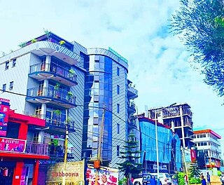
Nekemte, also spelled as Neqemte, is a market city and separate woreda in western Ethiopia. Located in the East Welega Zone of the Oromia Region, Nekemte has a latitude and longitude of 9°5′N36°33′E and an elevation of 2,088 meters.

East Welega is one of the zones in the central Oromia Region of Ethiopia. This administrative division acquired its name from the former province of Welega. Towns and cities in this zone include Nekemte.
Bure is one of the woredas in the Oromia Region of Ethiopia. Part of the Illubabor Zone, Bure is bordered on the south by Nono, on the southwest by the Gambela Region, on the west by the Kelem Welega Zone, on the northeast by Metu, and on the southeast by Ale; the Birbir River defines the west and north boundaries. Towns in Bure include Bure and Sibo. Huka Halu woreda was separated from Bure.
Cheliya is one of the Aanaas in the Oromia of Ethiopia. Part of the West Shewa Zone, Cheliya is bordered on the south by Nono and Dano, on the southwest by the Gibe River which separates it from the Jimma Zone, on the west by Bako Tibe, on the northwest by the Guder River which separates it from the Horo Gudru Welega Zone, on the north by Ginde Beret, on the northeast by Jeldu, on the east by Ambo, and on the southeast by Tikur. The administrative center of this Aanaa is Gedo; other towns in Cheliya include Babiche, Ejaji, and Hamus Gebeya. Midakegn woreda was separated form Cheliya.
Sebata Hawas, also spelled Sabbataa Awaas, is a woreda in Oromia Region, Ethiopia. Part of the Oromia Special Zone Surrounding Finfinne, Alem Gena is on the southwest by Southwest Shewa Zone, on the northwest by Walmara, on the north by Burayu, on the northeast by the city of Addis Ababa, and on the east by the Akaki. The Awash River defines this woreda's boundary with south west Shewa Zone. The towns in Sebeta Hawas include Sebeta Hawas (Town), Awash Melka, and Tefki. The town of Sebeta was separated from this district.
Gimbi is a woreda in Oromia Region, Ethiopia. Part of the West Welega Zone, Gimbi woreda is bordered on the south by Haru, on the southwest by Yubdo, on the west by Lalo Asabi, on the north by the Benishangul-Gumuz Region, on the east by the East Welega Zone, and on the southeast by an exclave of the Benishangul-Gumuz Region. The administrative center for this woreda is Gimbi. Homa woreda was part of Gimbi woreda.
Hawa Welele was one of the woredas in the Oromia Region of Ethiopia. Part of the Mirab Welega Zone, Hawa Welele was bordered on the south by Sayo, on the west by Anfillo, on the northwest by Jimma Gidami, on the north and east by Gawo Dale, and on the southeast by the Illubabor Zone. The administrative center of this woreda was Rob Gebeya; other towns in Hawa Welele included Tejo. Hawa Welele was separated for Hawa Gelan and Yemalogi Welele woredas.
Gawo Dale was one of the woredas in the Oromia Region of Ethiopia. Part of the Mirab Welega Zone, Gawo Dale was bordered on the south by Hawa Welele, on the west by Jimma Gidami, on the northwest by Begi, on the north by Jarso, on the northeast by Ayra Guliso, on the east by Dale Lalo, and on the southeast by the Illubabor Zone. The administrative center of this woreda was Kake; other towns in Gawo Dale included Chanka. It was separated for Dale Wabera and Gawo Kebe woredas.
Yubdo or Jubdo is a woreda in Oromia Region, Ethiopia. Part of the West Welega Zone, Yubdo is bordered on the south by Nole Kaba, on the west by Kelem Welega Zone, on the northwest by Ayra Guliso, on the northeast by Lalo Asabi, on the east by Gimbi, and on the southeast by Haru. The administrative center of this woreda is Yubdo; other towns in Yubdo include Ganji.
Haru is one of the 180 Aanaas in Oromia Region of Ethiopia. Part of the West Welega Zone, Haru is bordered on the south by Nole Kaba, on the southwest by Dale Lalo, on the west by Yubdo, on the north by Gimbi, on the east by an exclave of the Benishangul-Gumuz Region, and on the southeast by the Illubabor Zone. Towns in Haru include Guyi, Chonge and Guyi Abo.
Nole Kaba is one of the woredas in the Oromia region of Ethiopia. Part of the West Welega Zone, Nole Kaba is bordered on the south by the Illubabor Zone, on the west by Kelem Welega Zone, on the northwest by Yubdo, and on the northeast by Haru. Towns in Nole Kaba include Bube. Sayo Nole woreda was separated from Nole Kaba.
Berek is a woreda or district in Oromia Region, Ethiopia. It was part of the former Berek Aleltu woreda which was separated for Aleltu and Berek woredas and Sendafa Town. Part of the Oromia Special Zone Surrounding Finfinne, Berek is bordered on the south by the Akaki and East Shewa Zone, on the southwest by the city of Addis Ababa, on the west by Sululta, on the north by North Shewa Zone, and on the east by the Amhara Region.
Abe Dongoro is one of the woredas in the Oromia Region of Ethiopia. Part of the Horo Gudru Welega Zone, Abe Dongoro is bordered on the south and west by East Welega Zone, on the west by Gida Kiremu, on the north by Jardega Jarte, and on the east by Jimma Horo. The administrative center of this woreda is Tulu Wayu.
Guduru is a woreda in Oromia Region, Ethiopia. This woreda is named after one of the sections of the Macha Oromo, also known as the Torban Guduru, which coalesced into a kingdom around 1855 under Gama Moras, which lay between the Abay River and the Gibe region. It was also the location of the Battle of Embabo, fought 6 June 1882; the Shewan forces of Menelik defeated the Gojjame army, capturing Negus Tekle Haymanot and establishing a Shewan hegemony over the territories south of the Abay.
Bila Seyo was one of the 180 woredas in the Oromia of Ethiopia. It was divided between Gobu Seyo and Gudeya Bila woredas. Part of the East Welega Zone, Bila Seyo was bordered on the south by Wama Bonaya, on the southwest by Sibu Sire, on the west by Guto Wayu, on the north by Abe Dongoro, on the northeast by Jimma Horo, and on the east by the West Shewa Zone. The administrative center of the woreda was Ano; other towns in Bila Seyo included Bila and Jare.
Guto Wayu was one of the 180 woredas in the Oromia of Ethiopia. It was divided between Guto Gida, Wayu Tuka woredas and Nekemte town. Part of the East Welega Zone, Guto Wayu was bordered on the south by Nunu Kumba, on the southwest by Jimma Arjo and Diga Leka, on the west by Sasiga, on the northwest by Limmu and Gida Kiremu, on the northeast by Bila Seyo, on the east by Sibu Sire, and on the southeast by Wama Bonaya. The administrative center of the woreda was Nekemte, which is also the Zonal capital; other towns included Gute.
Sasiga is one of the woredas in the Oromia Region of Ethiopia and a part of the Misraq (East) Welega Zone. Sasiga is bordered on the south by Diga Leka, on the west by the Benishangul-Gumuz Region, on the northwest by Limmu, on the north by an exclave of the Benishangul-Gumuz Region and on the east by Guto Wayu. The administrative center of this woreda is Galo. Other towns in Sasiga include Handhura Balo, Bareda, Angar, Arb Gebeya, Ehud Gebeya, Gute and Tsige.
Jimma Arjo is an woreda in the Oromia Region of Ethiopia. It shares the name of Oromo people clan, the Jimma Arjo. Part of the East Welega Zone, Jimma Arjo is bordered on the southwest by the Didessa River which separates it from the Illubabor Zone, on the northwest by Diga Leka, on the northeast by Guto Wayu, and on the southeast by Nunu Kumba. The administrative center of this woreda is Arjo.
Sibuu Siree is one of woredas in the Oromia Region of Ethiopia. Part of the Misraq (East) Welega Zone, Sibu Sire is bordered on the south by Wama Bonaya, on the west by Guto Wayu, and on the north and east by Bila Seyo. The administrative center of this woreda is Sire.
Limmu Sakka is one of the woredas in the Oromia Region of Ethiopia. It is named in part after the former kingdom of Limmu-Ennarea, whose territories included the area this woreda now covers. Part of the Jimma Zone, Limmu Sakka is bordered on the southwest by the Didessa River which separates it from the Illubabor Zone, on the northwest by the Misraq Welega Zone, on the northeast by the Gibe River which separates it from the Mirab Shewa Zone, and on the southeast by Limmu Kosa. The administrative center of the woreda is Atnago; other towns include Saqqa, the capital of the former kingdom of Limmu-Ennarea.