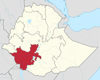
The Southern Nations, Nationalities, and Peoples' Region was a regional state in southwestern Ethiopia. It was formed from the merger of five kililoch, called Regions 7 to 11, following the regional council elections on 21 June 1992. Its government was based in Hawassa.

Dawro is a zone in the South West Region of Ethiopia. The name "Dawuro" represents both the land and the people. It is located at about 500km southwest of Addis Ababa, the capital of Ethiopia and 319 km of Hawassa, the capital of the Sidama Region. Dawuro is bordered on the south by Kucha in Gamo Zone, on the west by the Konta Zone, on the north by the Gojeb River which defines its boundary with the Oromia Region,Jimma zone, on the northeast by Hadiya and Tembaro Special Woreda in Central Ethiopia Regional State, and on the east by Wolayita Zone; the Omo River defines its eastern and southern boundaries.

Wolayita or Wolaita is an administrative zone in Ethiopia. Wolayita is bordered on the south by Gamo Zone, on the west by the Omo River which separates it from Dawro, on the northwest by Kembata Zone and Tembaro Special Woreda, on the north by Hadiya, on the northeast by the Oromia Region, on the east by the Bilate River which separates it from Sidama Region, and on the south east by the Lake Abaya which separates it from Oromia Region. The administrative centre of Wolayita is Sodo. Other major towns are Areka, Boditi, Tebela, Bale Hawassa, Gesuba, Gununo, Bedessa and Dimtu.

Diguna Fango is one of the woredas in the South Ethiopia Regional State of Ethiopia. It is a Part of the Wolayita Zone located in the Great Rift Valley, Diguna Fango is bordered on the southwest by Damot Weyde, on the west by Damot Gale, on the north by the Hadiya Zone, on the northeast by the Oromia Region, and on the east by Bilate river, which separates it from Sidama Region. The administrative center of the woreda is Bitena Town; the other major towns in the woreda include Dimtu, Kercheche, and Edo. Diguna Fango was separated from Damot Weyde woreda in 1998 E. C.

Dimtu or Wolaita Dimtu or Bilate Tena is a town in south-central Ethiopia. It has an elevation between 1,000 and 1,600 metres above sea level. It was part of the former Damot Weyde (Woreda) of Wolayita Zone, near to Sodo Zuria woreda. It is now under the Diguna Fango woreda. Some writers mention the town as Bilate Tena in their books and journals. Among them, Getahun Garedew, former Head Officer in Education Bureau of Southern Nations, Nationalities, and Peoples' Region, and State Minister of Ministry of Education since 2020, is the anterior. In the book "Local Adaptation Practices in Response to Climate Change in the Bilate River Basin, Southern Ethiopia", he used these two names, Dimtu and Bilate Tena, in a similar way.
Bedessa is a town in Wolayita Zone of the Southern Nations, Nationalities, and Peoples' Region, Ethiopia. The town is administrative capital of Damot Weyde district of Wolayita Zone, Ethiopia. Bedessa is located about 373 KM away from Addis Ababa to the south on Sodo-Dimtu-Hawassa road, and 21 KM away from Sodo, the capital of Wolaita Zone. The amenities in the town are, 24 hours electricity, pure public water, banks, schools, postal service, telecommunications services and others. The town has a wire bridge which connects the town with other surrounding communities. Bedessa lies between 6°52'58.9"N 37°55'58.5"E.

Gununo is a city in Wolaita, Ethiopia. The city is administrative capital of Damot Sore district of Wolayita Zone. Gununo is located 345 km far from Addis Ababa which is the capital city of Ethiopia, and 17 km away from the capital of Wolaita Zone which is Sodo. The other districts situated near to Gununo are; on the South by Sodo Zuria, on the North West by Boloso Bombe, on the West by Kindo Koysha, and on the East by Boloso Sore. The coordinate point of Gununo city is 6°55'21"N 37°38'57"E.

Bale Hawassa(Wolaytta: Bale Hawaassa) or in short Bale is a city in Wolayita Zone of South Ethiopia Regional State, Ethiopia. The city is one of seven city administrations in Wolaita Zone. It is administrative capital of Kindo Koysha district of Wolayita Zone, Ethiopia. Bale is located about 400 km away from Addis Ababa to the south on the path Addis-Butajira-Sodo and 38 km westward from Sodo, the capital of Wolaita Zone. The city has an average elevation 1500 meter above sea level. Bale Hawassa lies between 6°55'05" North, and 37°31'55" East.

Tebela or (Wolaita: Xabala) is a city in Wolaita Zone South Ethiopia Regional State. Tebela is an administrative capital of Humbo woreda district of Wolayita Zone. Tebela is located about 345 km away from Addis Ababa to the south. And also, Tebela is located 20 km, South from Sodo, the capital of the region and also Wolayita Zone. The coordinate point of the town in map is 6°42′24″N 37°46′10″E. The amenities in the town are; 24 hours electricity, pure public water, banks, primary and secondary schools, postal service, telecommunications services health centre, private clinics, drugs store, public market, public road light around high ways, internal and town crossing asphalt roads and others.

Kercheche or is a town in Diguna Fango woreda, Wolayita Zone of South Ethiopia Regional State. Kercheche is about 10 km (6.2 mi) north of Bedessa and about 8 km (5.0 mi) southwest of Bitena on the road of Sodo-Dimtu Hawassa. The approximate distance from the city of Addis Ababa to the town is 362 km (225 mi) on Addis-Hawassa-Dimtu-Sodo road. It is 38 km (24 mi) from Sodo, the capital of Wolayita Zone. The coordinate point of Kercheche lies between 6°57'21"N 37°59'29"E. The amenities in the town are 24-hours electric light, pure water service, kindergarten, primary school, high school, all time market, health stations and others. Kercheche has also dry weather and all weather roads which connect it to other surrounding areas.
Beklo Segno is a town in Wolayita Zone, Southern Nations, Nationalities, and Peoples' Region, Ethiopia. The town is an administrative center of Bayra Koysha district of Wolayita Zone, Ethiopia. Beklo Segno is located about 327 km away from Addis Ababa to the south on and 18 km away from Sodo to the West, the capital of Wolaita Zone. The amenities in the town are, 24 hours electricity, pure public water, banks, schools, postal service, telecommunications services and others. Beklo Segno lies between 6°55'0" N and 37°39'0" E. The town is located at an elevation of 1,932 meters above sea level.

Halale is a town in Wolayita Zone, of South Ethiopia Regional State, Ethiopia. The elevation of the town in meter is 1757. The town is n administrative capital of Kindo Didaye woreda of wolaita zone. And Halale Town lies between 6°47'24"N 37°22'52"E.
Bombe is a town in Wolayita Zone of the South Ethiopia Regional State, Ethiopia. Bombe town is located 325 km and 55 km away from Addis Ababa and Wolaita Sodo town through Hossana exit, respectively. Bombe town is used as an administrative capital of Boloso Bombe woreda of Wolaita Zone. It is located at an elevation of 1,531 meters above sea level. The amenities in the town are 24 hours electric light, pure water service, kindergarten, primary and high schools, health center, everyday public market and others. Bombe lies between about 7°08'04"North 37°34'54"East
Shanto is a town in southern Ethiopia. Located in the Wolaita Zone of the South Ethiopia Regional State, This town has a latitude and longitude of 7°01′ 23"N 37°51′49"E with an elevation of 1953 meters above sea level. The town is the administrative center of Damot Pulasa woreda.
Lasho is a town in Wolayita Zone of the South Ethiopia Regional State, Ethiopia. The approximate distance from the town of Sodo to Lasho is about 79 kilometres to Northwest via B52. And also the distance from Addis Ababa to Bombe is 388 km via Butajira-Worabe-Sodo to Southwest. Lasho town is used as an administrative capital of Kawo Koysha woreda of Wolaita Zone. It is located at an elevation of 2,130 meters above sea level. Lasho is a populated place in South Ethiopia Regional State. The amenities in the town are 24 hours electric light, pure water service, kindergarten, primary and high schools, health center, everyday public market and others. Lasho lies between about 6°42'29" North 37°28'23" East
Faracho or Abala Faracho is a town in Wolayita Zone, South Ethiopia Regional State, Ethiopia. The town is an administrative center of Abala Abaya district of Wolayita Zone, Ethiopia. Faracho is located about 349 km away from Addis Ababa to the south and also 30 km away from Sodo to the South, the capital of Wolaita Zone. The amenities in the town are, 24 hours electricity, pure public water, banks, schools, postal service, telecommunications services and others. Faracho lies between 6°55'0" N and 37°39'0" E. The town is located at an elevation of 1,378 meters above sea level.
Gacheno is a town in Wolayita Zone, South Ethiopia Regional State, Ethiopia. Gacheno is located about 287 km via B51 away from Addis Ababa to the south and also 31 km away from Sodo to the North, the capital of Wolaita Zone within Damot Gale woreda. The town is located at an elevation of 1,882 meters above sea level. Gacheno lies between 7°03'22" N and 37°55'14"E. The Ethiopian 3rd lady Roman Tesfaye was born and completed her primary school in this town.
Dalbo is a town in Southern Nations, Nationalities, and Peoples' Region, Ethiopia within Wolayita Zone. Dalbo is located about 304 km away from Addis Ababa to the south through Butajira. And the town is located 11 km, North from Sodo, the capital of Wolayita Zone. The coordinate point of the town in map is 6°54′0″N 37°52′0″E with elevation of 2349 meters above the sea level.
Edo is a town in Wolayita Zone of the Southern Nations, Nationalities, and Peoples' Region, Ethiopia. Edo town is located 310 km away from Addis Ababa and also 47 km from Wolaita Sodo town through Kercheche. The town is located in the north west edge of Diguna Fango woreda. Agricultural products are highly available in Edo town market which are produced from surrounding communities. The amenities in the town are 24 hours electric light, pure water service, kindergarten, primary and high schools, health center, everyday public market and others. Edo town lies between about 7°01'28" North 38°0'30" East. And the town located at an elevation of 1,730 meters above sea level.


