Gallery
- Mountains behind Sacato.
- Old arch on the Sacato side of the border in 2009 before the new checkpoint was built.
Sacato, sometimes spelled Sakato (Portuguese : Sacato, Tetum : Sakato), is a village in Timor-Leste. It is located in the suco of Nipane within the Pante Macassar Administrative Post in the Oecusse Special Administrative Region. It also the main border crossing between the East Timorese exclave of Oecusse and Indonesia. [1] [2] [3]
Sacato is located on the Oecusse coastline which is on the northern coast of Timor island. It is located to the west of the Noel Meto river which forms the Indonesia–Timor-Leste border. The mountains of Oecusse rise up behind Sacato.
The village is served by the main road from Pante Macassar, the capital of Oecusse which is located 15 km to the east. From Sacato, the distance to the main part of Timor-Leste via the Mota'ain/Batugade border crossing is about 75 km along the northern coastal road which traverses North Central Timor Regency and Belu Regency of Nusa Tenggara Timur, Indonesia.
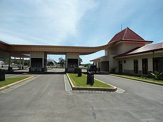
The Sacato integrated frontier checkpoint (Portuguese: Posto Fronteirico Integrado) is located 15 km east of Pante Makassar and just west of the bridge over the Noel Meto which forms the Indonesia–Timor-Leste border. The checkpoint on the Indonesia side is called the Wini border crossing checkpoint.
The checkpoint was newly built to cater to immigration, customs, quarantine and security procedures after Timor-Leste became independent. The facility was opened by Vice Prime Minister Jose Luis Guterres on 28 June 2012. [1] The border crossing is the main one for Oecusse as it is located on the shortest route between Oecusse and the main border crossing into the main part of Timor-Leste at Mota'ain/Batugade.
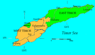
West Timor is an area covering the western part of the island of Timor, except for the district of Oecussi-Ambeno. Administratively, West Timor is part of East Nusa Tenggara Province, Indonesia. The capital as well as its main port is Kupang. During the colonial period, the area was named Dutch Timor and was a centre of Dutch loyalists during the Indonesian National Revolution (1945–1949). From 1949 to 1975 it was named Indonesian Timor.
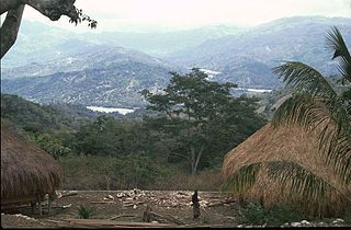
Bobonaro is a municipality in the Democratic Republic of Timor-Leste commonly known as East Timor. It is the second-most western municipality on the east half of the island. It has a population of 92,045 and an area of 1,376 km2.

Pante Macassar is a city in the Pante Macassar administrative post on the north coast of East Timor, 152 kilometres or 94 miles to the west of Dili, the nation's capital. It has a population of 4,730. It is the capital of the Oecusse exclave.

The Bunak people are an ethnic group that live in the mountainous region of central Timor, split between the political boundary between West Timor, Indonesia, particularly in Lamaknen District and East Timor. Their language is one of those on Timor which is not an Austronesian language, but rather a Papuan language, belonging to the Trans–New Guinea linguistic family. They are surrounded by groups which speak Malayo-Polynesian languages, like the Atoni and the Tetum.
Atambua is the regency seat of Belu Regency, East Nusa Tenggara, Indonesia.

Oecusse Airport, officially Oecusse Route of the Sandalwood International Airport, and formerly Palaban Airport, is an international airport serving Pante Macassar, the capital city of the Oecusse Special Administrative Region of East Timor.

The Tono River is the principal river of Oecusse, an exclave of East Timor. The river and its major tributaries flow generally north, through the centre of the exclave, into the Savu Sea, reaching the sea near Lifau. Its alluvial flood plain in Pante Macassar administrative post is the main rice-producing place in Oecusse.

The Noel Besi River is a river flowing in the west part of Timor island and forms part of the border between the East Timor exclave of Oecussi and Indonesian West Timor. It flows north into the Sawu Sea. Located 1900 km east of the Indonesian capital, Jakarta.

Lifau is a village and suco in the East Timor exclave of Oecusse District. The village is located west of the mouth of the Tono River. 1,938 people live in the suco.
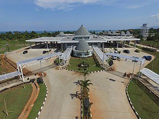
Mota'ain, also spelled Motain, Mota'in or Mota Ain, is a hamlet in the Silawan village (desa), East Tasifeto district (kecamatan), Belu Regency, East Nusa Tenggara, Indonesia.
Biawak is a settlement in Lundu District, Sarawak, Malaysia. It lies approximately 70.6 kilometres (44 mi) west of the state capital Kuching, very close to the border with Indonesian Kalimantan.

Oecusse, also known as Oecusse-Ambeno and formerly just Ambeno, officially the Special Administrative Region Oecusse-Ambeno, is an exclave, municipality and the only special administrative region (SAR) of East Timor.
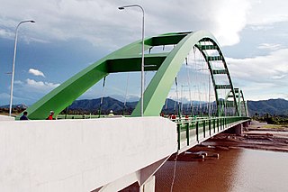
The Noefefan Bridge is a two-lane road bridge over the Tono River in the suco of Lifau, a village in Oecusse, the East Timorese exclave on the north western coast of Timor. As of 2017, when the bridge was inaugurated, it was the largest bridge ever built in East Timor. It connects several isolated communities west of the river with Pante Macassar to its east.

The East Timor–Indonesia border is the international border between East Timor and Indonesia. The border consists of two non-contiguous sections totalling 253 km in length, the larger section of which divides the island of Timor in two. The demarcation of the border between Indonesia and East Timor has been fought over by various parties for 350 years. The first attempts to define it precisely were made by the colonial powers of the Netherlands and Portugal with the Treaty of Lisbon in 1859, but it was not until the Permanent Court of Arbitration's award of 25 June 1914 that the final land border between them on the island of Timor was established. It largely coincides with today's border between the state of East Timor (Timor-Leste), which only gained its final independence in 2002, and West Timor, which belongs to Indonesia, but was still disputed on some points until 2019.

Berlin Nakroma is a roll-on/roll-off passenger and cargo ferry owned and operated by the Government of East Timor since 2007. A gift to East Timor from the Federal Republic of Germany, she links Dili, capital city of East Timor, with Pante Macassar in the East Timorese exclave of Oecusse, and with Atauro Island.
Batugade is a suco (village) located in Balibó Subdistrict, Bobonaro Municipality of East Timor. The administrative seat of the suco is the village of Batugade.
Wini is a village in the Nusa Tenggara Timur province of Indonesia. It is the capital of the North Insana district of the North Central Timor Regency. It is located on the north coast of the western part of the island of Timor, between East Timor to the east and its exclave of Oecusse to the west. A major border crossing checkpoint into East Timor's exclave of Oecussi is located here.
Salele is a village in East Timor located in the suco of Lalawa in the Tilomar Administrative Post of the Cova Lima Municipality. It is the location of the second main border crossing between the East Timor and Indonesia. The checkpoint on the Indonesian side of the border is called the Motamasin checkpoint.

Entikong is a district (kecamatan) and also an administrative village (desa) within that district in Sanggau Regency of West Kalimantan Province, Indonesia. It is the location of the main border crossing between the West Kalimantan and the Malaysian state of Sarawak. The checkpoint on the Malaysian side of the border is called the Tebedu immigration, customs, quarantine and security checkpoint.
Batek Island or Fatu Sinai is a small island located in East Nusa Tenggara Province (NTT), Indonesia. This island located in the Savu Sea, northwest of the island of Timor, 9.3 km off the East Timorese municipality of Oecusse.