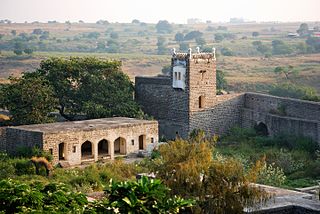
Nizamabad is also known as Induru is a city in the Indian state of Telangana. Nizamabad is a major urban agglomeration and third largest city in the state. It is governed by municipal corporation and is the headquarters of the Nizamabad district. Although previously part of Hyderabad State and then Andhra Pradesh state, Nizamabad became a part of the newly formed state of Telangana by the Andhra Pradesh Reorganisation Act, 2014.It is located about 186 kilometres (116 mi) north of the state capital, Hyderabad.
Kamareddy is a city and headquarters of eponymous district in Telangana state in India. It is located about 117 kilometres (73 mi) north of the state capital Hyderabad, 56 kilometres (35 mi) from Nizamabad and 96 kilometres (60 mi) from Karimnagar.

Nanded district is a district of Maharashtra state in central India. The city of Nanded is the district headquarters.

Nizamabad district is a district located in the north-western region in the Indian state of Telangana. The city of Nizamabad is the district headquarters.It was known as " Indur " which was supposed to have originated from the name of the King was Indradatta who seems to have flourished it during the 5th century A.D.The district share boundaries with Jagtial, Sircilla, Nirmal, Kamareddy districts and with Nanded district of the state boundary of Maharashtra.

Sircilla is a town and the district headquarters of Rajanna Sircilla district in the Indian state of Telangana. It is located on the banks of Manair river in the Sircilla mandal of Sircilla revenue division. It is popularly known as Textile Town due to the presence of large number of power looms, textile processing and dyeing units. It is the biggest textile hub in the state of Telangana with over 40,000 power looms. Sircilla, along with Warangal is proposed to be developed as a mega textile zone by the Telangana government. The first Visalandhra Mahasabha in Telangana was held at Sircilla during the Visalandhra movement.
Armoor is a city in a Nizamabad district in the state of Telangana in India. Armoor is situated on NH 7 and NH 63. In earlier days, it was called Navanathapuram since it has nine mountains around the town Armoor is a variation of it.Armoor is one of fastest growing city in the Telangana state
Kammarpally is a village & mandal in the Nizamabad district in the state of Telangana in India. It is situated on National Highway 63.
Madnur or Madnoor is a village in Nizamabad district in the state of Telangana in India.
Jukkal is a city in the Kamareddy revenue division of Kamareddy district in the Indian state of Telangana.
Bichkunda or Bichkonda is a Mandal in Kamareddy district of state of Telangana, India.
Tadwai is a village and a mandal in Kamareddy district in the state of Telangana in India, located between Kamareddy and Nijamsagar.

Gannaram is a village which is 150 km from Hyderabad. It is located in indalwai mandal, under the constituency of Nizamabad Rural of Nizamabad district, Telangana in south India.
Buthpur or Bhoothpur is a large area in Mahbubnagar district, Telangana.
Yadaram is a village and panchayat in Rangareddy district, Telangana, India. It comes under Medchal mandal. It is situated 14 km away from sub-district headquarter Domakonda and 84 km away from district headquarter Nizamabad. The total geographical area of village is 931 hectares. Yadaram has a total population of 2,230 people. There are about 571 houses in Yadaram village. Kamareddy is nearest town to Yadaram which is approximately 34 km away.
Badapahad Dargah, Peddagutta is a small town, village and Muslim pilgrim center. Built in the memory of the saint Syed Sadullah Hussain, the mosque is situated atop a hillock paidimal village in the Varni Mandal of Nizamabad district.
Karadpally is a village in Kamareddy district, Telangana, India.
Asifabad is a census town and the district headquarters of Kumuram Bheem district in the Indian state of Telangana. It is located in Asifabad mandal of Asifabad revenue division. It is situated on the banks of Peddavagu river. It is about 309 kilometres (192 mi) north of the state capital Hyderabad,86 kilometres (53 mi) from Ramagundam, 118 kilometres (73 mi) from Adilabad and 148 kilometres (92 mi) from Karimnagar.

Mupkal is a village in Mupkal Mandal in Nizamabad district of the Indian state of Telangana. It is located 39 kilometres (24 mi) north east of Nizamabad and 2 kilometres (1.2 mi) north from Balkonda, 15 km north of Armoor, 20 km south from Nirmal.

Nirmal district is a district located in the northern region of the Indian state of Telangana. The district headquarters is located in the town of Nirmal. It borders the Telangana districts of Adilabad, Nizamabad, Mancherial, Asifabad, Jagtial districts as well as Nanded district of the state Maharashtra.

Kamareddy district is a district located in the northern region of the Indian state of Telangana. The district shares boundaries with Medak, Nizamabad, Sangareddy, Siddipet and Rajanna Sircilla districts and with the state boundary of Maharashtra and Karnataka.


