
The Bitterroot Range is a mountain range and a subrange of the Rocky Mountains that runs along the border of Montana and Idaho in the northwestern United States. The range spans an area of 24,223 square miles (62,740 km2) and is named after the bitterroot, a small pink flower that is the state flower of Montana.

Borah Peak, also known as Mount Borah or Beauty Peak, is the highest mountain in the U.S. state of Idaho and one of the most prominent peaks in the contiguous United States. It is located in the central section of the Lost River Range, within the Challis National Forest in eastern Custer County. On February 11, 2021, the USGS officially recognized Mt. Borah as Idaho's only active glacier.
Castle Peak is the ninth highest summit of the Rocky Mountains of North America and the U.S. state of Colorado. The prominent 14,279-foot (4352.2 m) fourteener is the highest summit of the Elk Mountains and the Maroon Bells-Snowmass Wilderness. The peak is located 11.6 miles (18.7 km) northeast by north of the Town of Crested Butte, Colorado, United States, on the drainage divide separating Gunnison National Forest and Gunnison County from White River National Forest and Pitkin County. The summit of Castle Peak is the highest point of both counties.

Mount Wrightson is a 9,456-foot (2,882 m) peak in the Santa Rita Mountains within the Coronado National Forest, in southern Arizona, United States.

New Creek Mountain is a mountain ridge of the Ridge-and-Valley Appalachians in Grant and Mineral counties in the U.S. state of West Virginia. The mountain is named for New Creek which rises and flows along its western flanks. It is part of the Wills Mountain Anticline, with Knobly Mountain along its eastern flank. The Allegheny Front rises steeply to the west of New Creek Mountain. Oriskany (Ridgeley) sandstone cliffs ring the entire mountain.
Stripe Mountain is the highest point in both the South Clearwater Mountains and the Clearwater Mountains as a whole, part of the Bitterroot Range and Rocky Mountains in the panhandle of Idaho in the Western United States. Its summit is at an elevation of 9,001 ft (2,744 m) and the mountain's ridgeline forms the boundary of Idaho County and Lemhi County. The Idaho County portion of the mountain lies within the Bitterroot National Forest and the Lemhi County portion of the mountain lies within the Salmon-Challis National Forest, and the entirety of the mountain lies within the Frank Church-River of No Return Wilderness Area.

Mica Peak is the name of two separate mountain summits in the United States located approximately 5.49 miles (9 km) apart; one in Spokane County, Washington and the other in Kootenai County, Idaho. The two peaks are located along the same ridge, which separates the Spokane Valley and Rathdrum Prairie from the Palouse. The mountains have an elevation difference of only 31 ft (9.4 m) and are the southernmost peaks of the Selkirk Mountains.

Thompson Peak, at 10,751 feet (3,277 m) above sea level is the highest peak in the Sawtooth Range of Idaho. The summit of Thompson Peak is located within Custer County, although some of the lower portion of the mountain is in Boise County. Thompson Peak is also located within the Sawtooth Wilderness portion of the Sawtooth National Recreation Area, a unit of Sawtooth National Forest. The town of Stanley, Idaho is about 6 miles (9.7 km) northeast of Thompson Peak.

Castle Peak is a mountain in the western United States, the highest peak in the White Cloud Mountains of central Idaho and the Idaho Batholith. Located in Custer County, it is the 25th highest peak in the state, and the ninth most prominent.

Hyndman Peak, at an elevation of 12,012 feet (3,661 m) above sea level, is the ninth highest peak in Idaho and the highest point in the Pioneer Mountains, Sawtooth National Forest, and Blaine County. Hyndman Peak is located on the border of Custer and Blaine counties. The towns of Hailey, Ketchum, and Sun Valley are west of the peak.
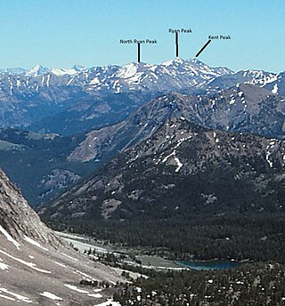
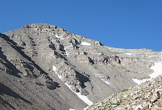
Kent Peak, at 11,664 feet (3,555 m) above sea level is the second highest peak in the Boulder Mountains of Idaho. Located on the border of Blaine and Custer counties, Kent Peak is about 0.75 miles (1,210 m) south of the range's highest point, Ryan Peak. The peak is also on the border of Sawtooth National Recreation Area and Salmon-Challis National Forest and partially within the Hemingway–Boulders Wilderness. It is the 34th highest peak in Idaho.

Braxon Peak, at 10,353 feet (3,156 m) above sea level is a peak in the Sawtooth Range of Idaho. The peak is located in the Sawtooth Wilderness of Sawtooth National Recreation Area on the border of Boise and Custer counties. The peak is located 1.36 mi (2.19 km) south of Mount Cramer, its line parent. It is also about 1.2 mi (1.9 km) south-southwest of Mount Heyburn. Braxon Lake is just southwest of the peak.
White Mountain, or White Mountain West, is the highest peak in the Salmon River Mountains in Idaho, USA, with an elevation of 10,442 feet (3,183 m).
Shelly Mountain is a mountain in Custer County, Idaho, in the White Knob Mountains. At 3439m (11,283 ft), it is the 13th highest peak with at least 500m of prominence in Idaho.
Dickey Peak is a mountain in Custer County, Idaho. At 3397m, it's the 14th highest peak in Idaho that has at least 500m of topographic prominence.
Lem Peak is a mountain in Lemhi County, Idaho. At 3349m, it is the 16th highest summit in Idaho that has at least 500m of topographic prominence.
