
The Bitterroot Range is a mountain range and a subrange of the Rocky Mountains that runs along the border of Montana and Idaho in the northwestern United States. The range spans an area of 24,223 square miles (62,740 km2) and is named after the bitterroot, a small pink flower that is the state flower of Montana.

Borah Peak, also known as Mount Borah or Beauty Peak, is a mountain in the western United States and the highest summit in Idaho. One of the most prominent peaks in the contiguous United States, it is located in the central section of the Lost River Range, within the Challis National Forest in eastern Custer County. On February 11, 2021, the USGS officially recognized Mt. Borah as Idaho's only active glacier.

The Lost River Range is a high mountain range of the Rocky Mountains, located in Central Idaho, in the Northwestern United States.

Mica Peak is the name of two separate mountain summits in the United States located approximately 5.49 miles (9 km) apart; one in Spokane County, Washington and the other in Kootenai County, Idaho. The two peaks are located along the same ridge, which separates the Spokane Valley and Rathdrum Prairie from the Palouse. The mountains have an elevation difference of only 31 ft (9.4 m) and are the southernmost peaks of the Selkirk Mountains.

Castle Peak is a mountain in the western United States, the highest peak in the White Cloud Mountains of central Idaho and the Idaho Batholith. Located in Custer County, it is the 25th highest peak in the state, and the ninth most prominent.
Ranger Peak is a mountain peak on the border of the U.S. states of Idaho and Montana.
Sublett Range High Point, at 7,492 feet (2,284 m) above sea level is the highest peak in the Sublett Range of Power County in southern Idaho, USA. It is located in the east-central part of the range north of Snowville, Utah, east of Malta, Idaho, and south of American Falls, Idaho, in the Sublett Division of the Minidoka Ranger District of Sawtooth National Forest.

Mount Harrison, at 9,265 feet (2,824 m) is a peak in the northern Albion Mountains of Cassia County in southern Idaho. Mount Harrison is located in north of Cache Peak, south of Burley, northeast of Oakley, and west of Malta in the Albion Division of the Minidoka Ranger District of Sawtooth National Forest. Mount Harrison is in the watershed of tributaries of the Snake River, which itself is a tributary of the Columbia River. The peak can be reached via a paved road that runs all the way to its summit. Lake Cleveland is located in the basin north of the peak, and a small unnamed lake is located in the basin southeast of the peak.
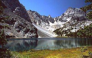
Mount Idaho, at 12,065 feet (3,677 m) above sea level is the seventh highest peak in Idaho and the sixth highest in the Lost River Range. The peak is located in Salmon-Challis National Forest in Custer Countyin the US State of the same name. It is 2.2 mi (3.5 km) south of Borah Peak, its line parent, and 2.8 mi (4.5 km) northwest of Leatherman Peak. Merriam Lake is in the basin to the northeast of the peak.

Decker Peak, at 10,704 feet (3,263 m) above sea level is the third highest peak in the Sawtooth Range of Idaho. The peak is located in the Sawtooth Wilderness of Sawtooth National Recreation Area in Custer County. The peak is located 2.3 mi (3.7 km) south-southwest of Mount Cramer, its line parent. It is the 204th highest peak in Idaho.

Merritt Peak, at 10,312 feet (3,143 m) above sea level is a peak in the Sawtooth Range of Idaho. The peak is located in the Sawtooth Wilderness of Sawtooth National Recreation Area in Custer County. The peak is located 1.08 mi (1.74 km) northwest of Williams Peak, its line parent. It is south-southwest of Goat Lake
White Cloud Peak 10, also known as WCP 10, at 11,102 feet (3,384 m) above sea level is an unofficially named peak in the White Cloud Mountains of Idaho. The peak is located in Sawtooth National Recreation Area in Custer County 0.53 mi (0.85 km) south of Calkins Peak, its line parent. It is the 89th highest peak in Idaho. Sheep Lake is directly south of the peak, and Tin Cup Lake is directly north of the peak.
Chinese Peak is a summit in Bannock County, Idaho, in the United States. This peak is the highest point in the portion of the Portneuf Range called the Pocatello Range. With an elevation of 6,791 feet (2,070 m), Chinese Peak is the 1069th highest summit in the state of Idaho. The peak is a fire lookout site and a road/bike trail leads to the top.
Shelly Mountain is a mountain in Custer County, Idaho, in the White Knob Mountains. At 3439 m (11,283 ft), it is the 13th highest peak with at least 500m of prominence in Idaho.
Lem Peak is a mountain in Lemhi County, Idaho. At 3349m, it is the 16th highest summit in Idaho that has at least 500m of topographic prominence.
Saddle Mountain is a mountain in Butte County, Idaho, located in the Lemhi Range. At 3296m, it is the 18th tallest peak in Idaho with at least 500m of topographical prominence.
Little Regret Peak is an 11,090-foot elevation (3,380 m) mountain summit located in Custer County, Idaho, United States.

Doublespring Peak is an 11,611-foot elevation (3,539 m) mountain summit located in Custer County, Idaho, United States.

Boulder Peak is a 10,981-foot elevation (3,347 m) mountain summit located in Blaine County, Idaho, United States.
