
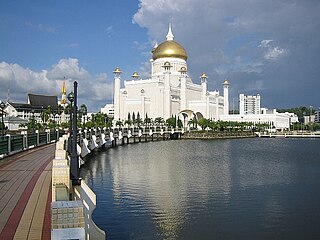
Bandar Seri Begawan is the capital and largest city of Brunei. It is officially a municipal area with an area of 100.36 square kilometres (38.75 sq mi) and an estimated population of 100,700 as of 2007. It is part of Brunei-Muara District, the smallest yet most populous district which is home to over 70 per cent of the country's population. It is the country's largest urban centre and nominally the country's only city. The capital is home to Brunei's seat of government, as well as a commercial and cultural centre. It was formerly known as Brunei Town until it was renamed in 1970 in honour of Sultan Omar Ali Saifuddien III, the 28th Sultan of Brunei and the father of the current Sultan, Hassanal Bolkiah.
The Brunei–Muara District or simply Brunei-Muara is one of the four districts of Brunei. It has the smallest area among the four districts, with 571 square kilometres (220 sq mi), yet is the most populous, with 289,630 people as of 2016. Bandar Seri Begawan, the country's capital, is located in this district, which is also de facto the district's capital. It is also home to Brunei International Airport, the country's only international airport, as well as Muara Port, the main and only deep-water port in the country. The Brunei River flows within this district and is home to Kampong Ayer, the traditional historic settlement on stilts above the river.

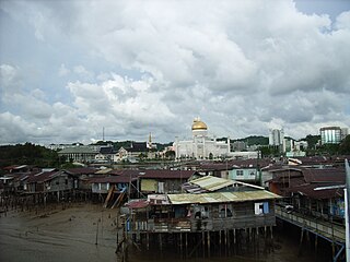
The Brunei River is a river which flows through Brunei and empties into the Brunei Bay towards the north-east direction. The Istana Nurul Iman, the official residence of the Sultan of Brunei, stands on its banks. The Brunei River is the shortest major river in Brunei. It is the major river basin within the Brunei-Muara District, the smallest but most populous district. It flows through the country's capital Bandar Seri Begawan. It is home to Kampong Ayer, the Brunei's traditional village on stilts above the river water.

Kampung Ayer is a prominent traditional settlement in Bandar Seri Begawan, the capital of Brunei. It comprises neighbourhoods of traditional houses, schools and mosques built on stilts above the Brunei River near the capital's city centre. It has an area of about 10 square kilometres (3.9 sq mi); the total population was 10,250 in 2016. It has been historically nicknamed 'Venice of the East'. Kampung Ayer has been historically the principal settlement of Brunei; it was the de facto capital, in particular social and economic centre, of the Bruneian Empire for a few centuries, but also extending into the early period during British imperialism in Brunei.
The administrative divisions of Brunei Darussalam mainly consist of daerah (districts), mukim (sub-districts), and kampung or kampong (villages). They are organised hierarchically in Brunei Darussalam, with daerah being the largest first level, and kampong the smallest third level.

Mukim Sungai Kedayan was a mukim in Brunei-Muara District, Brunei. It was located within Kampong Ayer, the historical stilt settlements on the Brunei River in the capital Bandar Seri Begawan. The population was 230 in 2016.

Kampong Jerudong or simply Jerudong is a village in Brunei-Muara District, Brunei, about 21 kilometres (13 mi) from the capital Bandar Seri Begawan. The population was 3,856 in 2016. It is one of the settlements within Mukim Sengkurong.

Pusat Bandar is the city centre of Bandar Seri Begawan, the capital of Brunei. It is home to a number of national landmarks, important government offices, and commercial and financial establishments.

Protected areas of Brunei are established by the Government of Brunei, in accordance with national development objectives and global biogeoecological strategies in which forests play an important role. The country's marine protected areas remained at 0.2% in 2022. As of 2011, nearly half of Brunei Darussalam is still primary forest, however this coverage is dwindling and only 17% of the country is officially protected.

Transport in Brunei consists of air, land, and sea transport. Previously there was some rail transport in Brunei, but eventually most of it was closed down. Several public and commercial sector organizations are in charge of creating and overseeing these networks and infrastructures. The Ministry of Transport and Infocommunications (MTIC) is in charge of overseeing the maritime and aviation industries, as well as planning and regulating all kinds of land transportation.

Taman Mahkota Jubli Emas, initially known as Eco-Corridor Park, is a riverfront public park in the former Mukim Sungai Kedayan of Bandar Seri Begawan, Brunei. The park was inaugurated on 22 October 2017 in conjunction with the Golden Jubilee of Sultan Hassanal Bolkiah's accession to the throne as the 29th and current Sultan of Brunei.
Kampong Kulapis is a village in the west of Brunei-Muara District, Brunei, about 13 miles (21 km) from the capital Bandar Seri Begawan. It has an area of 486.71 hectares ; the population was 1,766 in 2016. It is one of the villages within Mukim Sengkurong.The postcode is BG2521.

Kampong Kapok is a village in the north-east of Brunei-Muara District, Brunei and has an area of 1,241.01 hectares ; the population was 2,791 in 2016.

Kampong Pancha Delima is a village in Brunei-Muara District, Brunei, and a neighbourhood in the capital Bandar Seri Begawan. The population was 1,562 in 2016. It is one of the villages within Mukim Berakas 'A'. The postcode is BB4513.

Kampong Madang is a village in Brunei-Muara District, Brunei, as well as a neighbourhood in the capital Bandar Seri Begawan. The population was 1,231 in 2016. It is one of the villages within Mukim Berakas 'B'. The postcode is BC3715.

Kampong Kiarong or commonly known as Kiarong, is a village in Brunei-Muara District, Brunei, as well as a neighbourhood in the country's capital Bandar Seri Begawan. It has an area of 383.43 hectares ; the population was 4,530 in 2016.
Limbongan was a neighbourhood in Kampong Ayer, the riverine stilt settlement in Bandar Seri Begawan, the capital of Brunei. It was officially a village subdivision under Tamoi, a mukim (subdistrict) of Brunei-Muara District, and had the postcode BL1312. Limbongan was one of the traditional stilt neighbourhoods which had existed along the banks of the Kedayan River, a tributary of the Brunei River in the vicinity of Kampong Ayer, before they were eventually demolished in the 2010s and redeveloped into Taman Mahkota Jubli Emas, a riverfront park.

Kampong Kumbang Pasang, or simply Kumbang Pasang, is a village within Mukim Kianggeh in Brunei-Muara District, Brunei. It is also part of the municipal area of the capital Bandar Seri Begawan. The population was 563 in 2016. It has the postcode BA1511. The village formerly hosts a rubber plantation and was named Kumbang Pasang Estate. Notably the village was once its own Mukim, known as Mukim Kumbang Pasang.

Kampong Lumapas is a village in Brunei-Muara District, Brunei, located in the southern outskirts of the capital Bandar Seri Begawan. The population was 2,709 in 2016. It is one of the villages within Mukim Lumapas.
Kampong Belimbing or silly known as Belimbing, is a village in Brunei-Muara District, Brunei. It is also a neighbourhood in the capital Bandar Seri Begawan. The population was 2,721 in 2016. It is one of the villages within Mukim Kota Batu. The postcode is BD2917.

