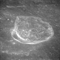
Lunar Orbiter 2 image | |
| Coordinates | 1°36′S102°42′E / 1.6°S 102.7°E |
|---|---|
| Diameter | 99 km |
| Depth | Unknown |
| Colongitude | 258° at sunrise |
| Eponym | Meghnad Saha |


Saha is a lunar impact crater on the Moon's far side, behind the eastern limb as seen from the Earth. It lies less than one crater diameter due east of the similar-sized Wyld, and to the north-northwest of the large walled plain Pasteur.
This crater has been worn and damaged by subsequent impacts, including the satellite crater Saha W which lies across the northwest rim and inner wall. The inner sides still display some terrace-like shelf structures, but these have become worn and have lost definition. There is a small, bowl-shaped crater Saha M in the southwestern part of the interior floor. To the north of this feature is an arcing ridge feature. The floor is otherwise pitted by various tiny craterlets. This crater is a proposed site of Lunar Crater Radio Telescope along with Daedalus crater. [1]