Saint-Aubert, Quebec

Last updated
Saint-Aubert
Municipality
Saint-Aubert Quebec location diagram.png
Location within L'Islet RCM.
Canada Southern Quebec location map.png
Red pog.svg
Saint-Aubert
Location in southern Quebec.
Coordinates: 47°11′N70°13′W / 47.183°N 70.217°W / 47.183; -70.217 Coordinates: 47°11′N70°13′W / 47.183°N 70.217°W / 47.183; -70.217 [1]
CountryFlag of Canada.svg  Canada
Province Flag of Quebec.svg  Quebec
Region Chaudière-Appalaches
RCM L'Islet
Constituted 1 July 1857
Government [2]
  Mayor Ghislain Deschene (2016-)
   Federal riding Montmagny—L'Islet—
Kamouraska—Rivière-
du-Loup
   Prov. riding Côte-du-Sud
Area [2] [3]
  Total 100.90 km2 (38.96 sq mi)
  Land 100.41 km2 (38.77 sq mi)
Population (2011) [3]
  Total 1,409
  Density 14.0/km2 (36/sq mi)
  Pop 2006-2011Decrease2.svg 4.0%
  Dwellings 944
Time zone EST (UTC−5)
  Summer (DST) EDT (UTC−4)
Postal code(s) G0R 2R0
Area code(s) 418 and 581
HighwaysQc204.svg Route 204
Website saint-aubert.net

Saint-Aubert is a municipality in Quebec, situated in the L'Islet Regional County Municipality and the Chaudière-Appalaches administrative region. Saint-Aubert lies in the Côte-du-Sud federal electoral district.

Quebec Province of Canada

Quebec is one of the thirteen provinces and territories of Canada. It is bordered to the west by the province of Ontario and the bodies of water James Bay and Hudson Bay; to the north by Hudson Strait and Ungava Bay; to the east by the Gulf of Saint Lawrence and the province of Newfoundland and Labrador; and to the south by the province of New Brunswick and the U.S. states of Maine, New Hampshire, Vermont, and New York. It also shares maritime borders with Nunavut, Prince Edward Island, and Nova Scotia. Quebec is Canada's largest province by area and its second-largest administrative division; only the territory of Nunavut is larger. It is historically and politically considered to be part of Central Canada.

LIslet Regional County Municipality Regional county municipality in Quebec, Canada

L'Islet is a regional county municipality in the Chaudière-Appalaches region of Quebec, Canada.

Chaudière-Appalaches Region in Quebec, Canada

Chaudière-Appalaches is an administrative region in Quebec, Canada. It comprises most of what is historically known as the "Beauce". It is named for the Chaudière River and the Appalachian Mountains.

Contents

Geography

Saint-Aubert is situated between St-Jean-Port-Joli and Saint-Damase-de-L'Islet, not far from the southern coast of the Saint Lawrence River, some 100 kilometres (62 mi) from Quebec City. The landscape of Saint-Aubert is defined by its plateaus and hills. Near the village, one may find part of the Notre Dame Mountains, which are an extension of the Appalachians, as well as Three-Salmon Lake (Lac Trois-Saumons).

Saint-Jean-Port-Joli, Quebec Municipality in Quebec, Canada

Saint-Jean-Port-Joli is a village in the Regional County Municipality of L'Islet within the Chaudière-Appalaches region of Quebec, Canada. It is located on the south shore of the Saint Lawrence River and is the county seat. The village is located off the Trans-Canada Highway, Autoroute 20. Route 132 passes through the town.

Saint Lawrence River Large river in eastern Canada and the United States, flowing into the Gulf of Saint Lawrence

The Saint Lawrence River is a large river in the middle latitudes of North America. The Saint Lawrence River flows in a roughly north-easterly direction, connecting the Great Lakes with the Atlantic Ocean and forming the primary drainage outflow of the Great Lakes Basin. It traverses the Canadian provinces of Quebec and Ontario, and is part of the international boundary between Ontario, Canada, and the U.S. state of New York. This river also provides the basis of the commercial Saint Lawrence Seaway.

Quebec City Provincial capital city in Quebec, Canada

Quebec City, officially Québec, is the capital city of the Canadian province of Quebec. The city had a population estimate of 531,902 in July 2016, and the metropolitan area had a population of 800,296 in July 2016, making it the second largest city in Quebec after Montreal, and the seventh largest metropolitan area and eleventh largest city in the country.

[Three-Salmon Lake is a]...stunning basin cut from the whiteness of quartz.
Brother Marie-Victorin, Croquis laurentiens [4]

Economy

The village's primary activities are agriculture and maple syrup production. Many from outside the region also choose to spend their holidays here; there is a significant summer camp called Camp Trois-Saumons, which was founded in 1947 on the banks of its eponymous lake. [5] Aside from these activities, the village does contain a number of small boutiques.

History

In 1857, one year following the establishment of St-Aubert as a parish, the St-Aubert municipality was formed from the southern part of St-Jean-Port-Joli. The village was named in honour of Saint Aubert of Avranches, French bishop and founder of what went on to become the Mont Saint-Michel. However, the name was mostly chosen so as to honour Philippe-Joseph Aubert de Gaspé, lord of St-Jean-Port-Joli. Then-lawyer and sheriff of the Québec district, he was relieved of his responsibilities and found guilty of significant misappropriation of funds. He was imprisoned in 1838. In 1842, he moved to Quebec City and chose to spend his summers in St-Jean-Port-Joli. As he grew old, he published regionally-renowned books Anciens Canadiens (1863) and Mémoires (1866). The people of St-Aubert went on to witness the tripling of their economy in agriculture, holiday-making, and maple syrup production. [1] Shortly before his death, Elgin road (today known as Route 204) was constructed from St-Jean-Port-Joli to the Canada–US border; this facilitated the development of St-Aubert and other villages in the Côte-du-Sud.

Aubert of Avranches Bishop of Avranches

Saint Aubert, also known as Saint Autbert, was bishop of Avranches in the 8th century and is credited with founding Mont Saint-Michel.

Seigneurial system of New France

The manorial system of New France was the semi-feudal system of land tenure used in the North American French colonial empire.

Côte-du-Sud is a provincial electoral district in the Bas-Saint-Laurent and Chaudière-Appalaches regions of Quebec, Canada, which elects members to the National Assembly of Quebec. It includes the entire territory of the following regional county municipalities: Montmagny, L'Islet, Kamouraska; larger towns include Montmagny and La Pocatière.

The development of Saint-Aubert as a holiday-making destination took shape in 1904 with the opening of a fishing camp called Camp Maria-Joseph on Lac Trois-Saumons by the Notre-Dame-de-Bonsecours fishing club. The abundant fish on the lake (particularly trout) drew families from around the area, particularly from nearby L'Islet.

LIslet, Quebec Municipality in Quebec, Canada

L'Islet is a municipality within L'Islet Regional County Municipality in the Chaudière-Appalaches region of Quebec, Canada.

See also

Related Research Articles

Bellechasse was a federal electoral district in Quebec, Canada, that was represented in the House of Commons of Canada from 1867 until the 1997 election, when it became Bellechasse—Etchemins—Montmagny—L'Islet. After redistribution prior to the 2004 election, that riding became Lévis—Bellechasse. Currently, the only riding which includes the name "Bellechasse" is Bellechasse—Les Etchemins—Lévis.

The 2000–2006 municipal reorganization in Quebec resulted in large-scale amalgamation (merging) of smaller municipalities in Quebec into larger cities. It was undertaken by one administration, and modified and partially undone by its successor.

Saint-Damase-de-LIslet Municipality in Quebec, Canada

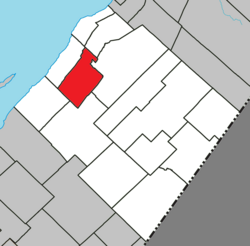
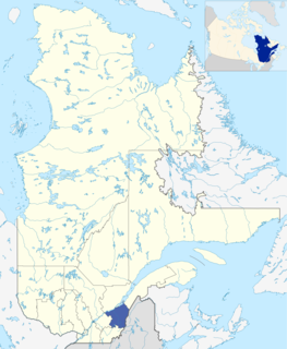
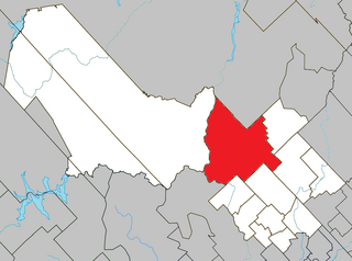
Saint-Damase-de-L'Islet is a municipality in Quebec, Canada, with a population of about 600 people nestled in the Appalachian mountains. It is located about 15 kilometres (9.3 mi) southeast of Saint-Jean-Port-Joli. It is named after the Pope Damasus I and Damase Ouellet (1826–1908), which is known as the pioneer of the town.

Quebec Route 204 highway in Quebec

Route 204 is a finite two-lane east/west highway on the south shore of the Saint Lawrence River in Quebec. It is one of the longest secondary highways in the province. Its eastern terminus is in Saint-Jean-Port-Joli at the junction of Route 132 and the western terminus is in Lac-Mégantic at the junction of Route 161. Although it is numbered as an east/west highway, the road follows a north/south course from Saint-Jean-Port-Joli to Saint-Pamphile, where it then follows a mostly southwest/northeast course until Saint-Georges, where after crossing the Chaudière River, follows it in a north/south course until the source of the Chaudiere in Megantic Lake, in Lac-Mégantic.

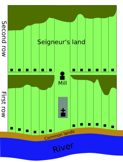
The municipal history of Quebec started in 1796 with the creation of administrations for Montréal and Quebec City, but it really developed immediately prior to the creation of the Province of Canada in 1841 with the formation of municipal districts, followed in March 1845 when the Parliament of the Province of Canada adopted an Act to create local authorities in Lower Canada which took effect in July 1845.

Matapedia Valley valley in Quebec, Canada

The Matapedia Valley was formed by the Chic-Choc Mountains of eastern Québec. Its name is derived from the river that traverses the valley, as well as the lake that lies in its center. It is situated in the southwest of the Gaspé Peninsula and stretches 375 km (233 mi).

Pierre-Ignace Aubert de Gaspé was a seigneur and political figure in Lower Canada.

Sainte-Thècle, Quebec Municipality in Quebec, Canada

Sainte-Thècle is a Canadian municipality located in the province of Quebec in the Mékinac Regional County Municipality, in the Batiscanie watershed, in the administrative region of Mauricie. This municipality of 216 square kilometres is known for its resorts and many small lakes. The forest and mountain scenery offers exceptional views for tourists and vacationers. Sainte-Thècle is also a destination for hunting, fishing, snowmobile/all-terrain vehicles and other outdoor sports. The church, rectory and cemetery are located on the main hill of the village and are also heritage sites of iinterest. The municipality's agricultural and forestry industries have marked its history.

Montmagny-L'Islet is a former provincial electoral district in the Chaudière-Appalaches region of Quebec, Canada that elected members to the National Assembly of Quebec. As of its final election, it included the cities or municipalities of Montmagny, Saint-Jean-Port-Joli, L'Islet, Sainte-Perpétue, Saint-Pamphile and Cap-Saint-Ignace.

Grandes-Piles, Quebec Village municipality in Quebec, Canada

Grandes-Piles is a village municipality in the Mauricie region of the province of Quebec in Canada.

Lac-aux-Sables, Quebec Parish municipality in Quebec, Canada

Lac-aux-Sables is a parish municipality in the Mékinac Regional County Municipality, in administrative district of the Mauricie region of the province of Quebec in Canada. Its population centres are Lac-aux-Sables and Hervey-Jonction.

Trois-Rives, Quebec Municipality in Quebec, Canada

Trois-Rives is a municipality with an area of 675 square kilometres (261 sq mi) located in Mékinac Regional County Municipality, in the Mid-Mauricie, province of Quebec, Canada.

Lac-au-Saumon, Quebec Municipality in Quebec, Canada

Lac-au-Saumon is a municipality in the Canadian province of Quebec, located in La Matapédia Regional Council Municipality in the Matapédia Valley.

Pamphile-Gaspard Verreault was a farmer, notary and political figure in Quebec. He represented L'Islet in the Legislative Assembly of Quebec from 1867 to 1878 as a Conservative member.

André Rousseau Canadian politician

André Rousseau,, was an entrepreneur and politician in Quebec. He was the first to occupy the position of Minister of Industry and Commerce from July 5, 1960 to December 5, 1962 under the first Government of Jean Lesage. In 1950, Rousseau also founded Rousseau Metal inc., a Quebec company that is specialized in the manufacturing of storage systems.

The 2004 Quebec municipal referendums were held by the Quebec Liberal Party government of Jean Charest that came to power in the 2003 Quebec election, in fulfillment of a campaign promise to allow voters to have a say regarding the municipal reorganization program that had been undertaken by the preceding Parti Québécois administration.

Missionary Lake

Missionary Lake [formerly named "Grand lac long" ] is located in the municipalities of Trois-Rives and Lac-aux-Sables in the Mekinac Regional County Municipality (RCM), in Batiscanie, in the administrative area of the Mauricie, in the province of Quebec, Canada. It is named in honour of missionary and explorer Paul Le Jeune, one of the founders of the Jesuit mission that was opened in 1634 in nearby Trois-Rivières, Quebec.

References

  1. 1 2 Reference number 55676 of the Commission de toponymie du Québec (in French)
  2. 1 2 Geographic code 17055 in the official Répertoire des municipalités (in French)
  3. 1 2 "(Code 2417055) Census Profile". 2011 census . Statistics Canada. 2012.
  4. Kirouac, Marie-Victorin (1982). Croquis laurentiens (in French). Montréal: Fides. p. 64. ISBN   2762111625. "...étonnante vasque taillée dans la blancheur du quartz."
  5. Camp Trois-Saumons official website (in French)