Tourville, Quebec

Last updated • 2 min readFrom Wikipedia, The Free Encyclopedia

Tourville
Eglise Saint-Clement - Tourville.jpg
Church of Tourville
Tourville Quebec location diagram.png
Location within L'Islet RCM
Canada Southern Quebec location map.png
Red pog.svg
Tourville
Location in southern Quebec
Coordinates: 47°06′N69°59′W / 47.100°N 69.983°W / 47.100; -69.983 [1]
CountryFlag of Canada (Pantone).svg  Canada
Province Flag of Quebec.svg  Quebec
Region Chaudière-Appalaches
RCM L'Islet
ConstitutedNovember 14, 1918
Government
[2]
  MayorBenoit Dubé
   Federal riding Montmagny—L'Islet—
Kamouraska—Rivière-
du-Loup
   Prov. riding Côte-du-Sud
Area
  Total165.10 km2 (63.75 sq mi)
  Land164.36 km2 (63.46 sq mi)
Population
 (2021) [3]
  Total576
  Density3.5/km2 (9/sq mi)
  Pop 2016-2021
Decrease2.svg 2.2%
  Dwellings
337
Time zone UTC−5 (EST)
  Summer (DST) UTC−4 (EDT)
Postal code(s)
Area code(s) 418 and 581
HighwaysQc204.svg R-204
Website www.muntourville.qc.ca

Tourville is a municipality in the L'Islet RCM in Quebec, Canada. It is located in the Chaudière-Appalaches administrative region.

Contents

History

The parish of Saint-Clément-de-Tourville, which served as a mission from 1913-1919, was officially founded in 1919 by an abbot named Bernard-Édouard Martin. The citizens wished to name it Martinville in his honour, but since there was another post office that had been established under this name, they opted for Tourville, which also honours Saint Martin of Tours. [1]

A road to the village (today known as Route 204), was constructed between 1854 and 1859. At that time, the village had already been taking advantage of the abundant wood, particularly pine. In 1856, a farmer from Saint-Roch-des-Aulnaies settled near Black Lake and lowered its water level by digging an outlet in hopes of making a pasture. During winter, he would use a special shovel that caused the lake to rise once again, which protected the seeds from freezing. In 1858, construction began on sawmills along the Ouelle and Le Bras rivers.

Railroad construction took place between 1905 and 1915 which went on to run from the municipality of Charny to Edmundston. Two hotels had already been built to accommodate the travellers. A roundhouse was built, in addition to a carbon chute, a water reservoir, and a train station named in the honor of former Chief Justice of Lower Canada James Monk. The roundhouse eventually closed in 1954, and in 1958 was replaced by the Napoléon Gagnon sawmill which burned down in 1972. The train station was demolished in 1982 and its rails, as well as recreational vehicle trails, were removed. [4] The population has since decreased to 698.

In 1918, Abbot Martin built a 2-story fishing cabin on the southern tip of the Lake Therrien lock. This area, then known as Beaubien, gave work to about sixty people to cut and drive logs along the river. For this reason, in 1923, Power Lumber became active, followed by La Rivière Ouelle Lumber's opening of a steam-powered saw to square the harvested logs in 1926. In 1927, the Canadian National Railway opened a sidetrack that would allow wood to be loaded without disrupting train traffic. Twenty-something families settled around the lake. In 1928, a school was at last built in Tourville. In 1939, the mill on the lake closed down.

See also

Related Research Articles

<span class="mw-page-title-main">Rivière-Ouelle</span> Municipality in Quebec, Canada

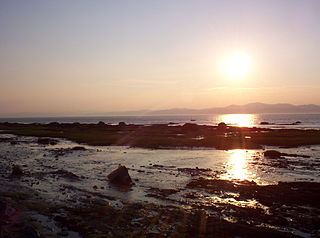
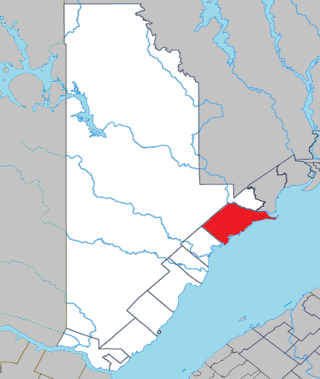
Rivière-Ouelle is a town located in the Kamouraska Regional County Municipality within the Bas-Saint-Laurent region of Quebec. It is located on the Saint Lawrence River; the Ouelle River flows through the town. It was part of the seignory of La Bouteillerie, once owned by Charles Deschamps de Boishébert et de Raffetot. Jean-Charles Chapais, a Father of Canadian Confederation, was born here.

<span class="mw-page-title-main">Low, Quebec</span> Township municipality in Quebec, Canada

Low is a township municipality in the La Vallée-de-la-Gatineau Regional County Municipality of western Quebec, Canada. It is situated along the Gatineau River north of Wakefield, and it is located within Canada's National Capital Region. Its 2021 population was 1,020.

<span class="mw-page-title-main">Saint-Évariste-de-Forsyth, Quebec</span> Place in Quebec, Canada

Saint-Évariste-de-Forsyth was a municipality in the Municipalité régionale de comté de Beauce-Sartigan in Quebec, Canada. It was part of the Chaudière-Appalaches region and the population was 647 at the 2006 census.

<span class="mw-page-title-main">Saint-Isidore-de-Clifton</span> Municipality in Quebec, Canada

Saint-Isidore-de-Clifton is a municipality of 700 people in Le Haut-Saint-François Regional County Municipality, in Quebec, Canada on the Canada–United States border. Saint-Isidore-de-Clifton is the source of the Eaton and Clifton rivers.

<span class="mw-page-title-main">Notre-Dame-de-Montauban</span> Municipality in Quebec, Canada

Notre-Dame-de-Montauban is a municipality in the Mauricie region in Quebec, Canada. The municipality is on the northern edge of Mékinac Regional County Municipality and the administrative region of Mauricie and includes the population centres of Notre-Dame-des-Anges and Montauban-les-Mines. Both communities are located along route 367 and are about 7 kilometres (4.3 mi) apart.

<span class="mw-page-title-main">Sainte-Sophie-d'Halifax</span> Municipality in Quebec, Canada

Sainte-Sophie-d'Halifax is a municipality in the Centre-du-Québec region of the province of Quebec in Canada.

<span class="mw-page-title-main">Saint-Zotique</span> City in Quebec, Canada

Saint-Zotique is a city located within the Vaudreuil-Soulanges Regional County Municipality in the Montérégie region located about 45 minutes west of Montreal, Quebec, Canada. It is named for Saint Zoticus of Comana.

<span class="mw-page-title-main">Aumond</span> Township municipality in Quebec, Canada

Aumond is a township municipality in the Canadian province of Quebec, located within La Vallée-de-la-Gatineau Regional County Municipality.

<span class="mw-page-title-main">Chichester, Quebec</span> Township municipality in Quebec, Canada

Chichester is a township municipality and village in the Canadian province of Quebec, located within the Pontiac Regional County Municipality.

<span class="mw-page-title-main">Ouelle River</span> River in LIslet and Kamouraska in Quebec (Canada)

The Ouelle River is a tributary of the south shore of the St. Lawrence River, in the province of Quebec, in Canada. This river flows successively in the MRC of:

<span class="mw-page-title-main">Saint-Cyprien, Bas-Saint-Laurent</span> Municipality in Quebec, Canada

Saint-Cyprien is a municipality in Rivière-du-Loup Regional County Municipality in the Bas-Saint-Laurent region of Quebec, Canada.

<span class="mw-page-title-main">Saint-Étienne-de-Beauharnois</span> Municipality in Quebec, Canada

Saint-Étienne-de-Beauharnois is a municipality of Quebec, Canada, located within the Beauharnois-Salaberry Regional County Municipality in the Montérégie administrative region. The population as of the Canada 2021 Census was 1,099.

<span class="mw-page-title-main">Colombier, Quebec</span> Municipality in Quebec, Canada

Colombier is a municipality in the Canadian province of Quebec, located in the Côte-Nord region and the regional county municipality of La Haute-Côte-Nord. It is located along Route 138, about 60 kilometres (37 mi) south-west of Baie-Comeau.

<span class="mw-page-title-main">Lac-du-Cerf</span> Municipality in Quebec, Canada

Lac-du-Cerf is a municipality in the Laurentides region of Quebec, Canada, part of the Antoine-Labelle Regional County Municipality. It is located on and named after Lac du Cerf.

<span class="mw-page-title-main">Saint-Jean-de-la-Lande, Quebec</span> Municipality in Quebec, Canada

Saint-Jean-de-la-Lande is a municipality in Témiscouata Regional County Municipality in the Bas-Saint-Laurent region of Quebec, Canada.

<span class="mw-page-title-main">Rivière-Bleue</span> Municipality in Quebec, Canada

Rivière-Bleue is a municipality in Quebec with more or less 1500 inhabitants. The municipality is located in the Bas-Saint-Laurent region on the border of the province of New-Brunswick and Canada–United States border with Maine.

<span class="mw-page-title-main">Saint-Marcel, Quebec</span> Municipality in Quebec, Canada

Saint-Marcel is a municipality in Quebec located in the MRC de L'Islet in the Chaudière-Appalaches.

<span class="mw-page-title-main">Saint-Robert-Bellarmin</span> Municipality in Quebec, Canada

Saint-Robert-Bellarmin is a municipality in the Municipalité régionale de comté du Granit in Estrie, Quebec, Canada, located on the Canada–United States border. Population is 529 as of 2021.

<span class="mw-page-title-main">Dixville, Quebec</span> Municipality in Quebec, Canada

Dixville is a municipality in Quebec, Canada, situated east of Stanstead, in the regional county municipality of Coaticook and the region of Eastern Township.

The Bras de la Rivière Ouelle is a tributary of the Ouelle River, flowing entirely in the municipality of Tourville, in the L'Islet Regional County Municipality, in the administrative region of Chaudière-Appalaches, in province of Quebec, in Canada.

References

  1. 1 2 "Banque de noms de lieux du Québec: Reference number 63198". toponymie.gouv.qc.ca (in French). Commission de toponymie du Québec.
  2. 1 2 "Répertoire des municipalités: Geographic code 17035". www.mamh.gouv.qc.ca (in French). Ministère des Affaires municipales et de l'Habitation.
  3. 1 2 "Census Profile, 2021 Census - Tourville, Municipalité". 15 November 2023.
  4. Saint-Clément-de-Tourville, 1919-1994 (in French). Tourville, Québec: Comité du livre Saint-Clément-de-Tourville. 1993. ISBN   2980370207.