
Drummondville is a city in the Centre-du-Québec region of Quebec, located east of Montreal on the Saint-François River. The population as of the Canada 2016 Census was 68,601. The mayor of Drummondville is Alexandre Cusson.

Rouyn-Noranda is a city on Osisko Lake in the Abitibi-Témiscamingue region of Quebec, Canada.

Abitibi Regional County Municipality is a regional county municipality in the Abitibi-Témiscamingue region of Quebec. The seat is Amos.

Beauharnois-Salaberry is a regional county municipality in the Montérégie region of Quebec, Canada. Its seat is Beauharnois.

L'Islet is a regional county municipality in the Chaudière-Appalaches region of Quebec, Canada.

Rimouski-Neigette is a regional county municipality in the Bas-Saint-Laurent region of Quebec, Canada.

Témiscamingue is a regional county municipality in the Abitibi-Témiscamingue region of western Quebec, Canada. The county seat is Ville-Marie.
Cyrille is both a given name and a surname. Notable people with the name include:
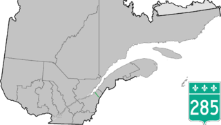
Route 285 is a 48 km two-lane north/south highway on the south shore of the Saint Lawrence River in the Chaudière-Appalaches region of Quebec, Canada. Its northern terminus is in L'Islet at the junction of Route 132 and the southern terminus is close to Saint-Adalbert at the junction of Route 204.

Saint-Joseph-de-Beauce is a city in the Municipalité régionale de comté Robert-Cliche in Quebec, Canada. It is part of the Chaudière-Appalaches region and the population was 4,722 as of the Canada 2011 Census.
Saint-Odilon-de-Cranbourne is a parish municipality in Robert-Cliche Regional County Municipality the Chaudière-Appalaches region of Quebec, Canada. Its population is 1,459 as of the Canada 2011 Census. The parish's name honours Reverend Pierre-François-Xavier-Odilon-Marie-Alphonse Paradis, first priest of Saint-Odilon-de-Cranbourne, while "Cranbourne" comes from Cranborne, a village in East Dorset, England.
Lotbinière is a municipality in Lotbinière Regional County Municipality in Quebec, Canada. It is part of the Chaudière-Appalaches region and the population was 887 as of the Canada 2011 Census. It is named after the seigneurie of which it was part. Bordered in the northwest by the Saint Lawrence River, Lotbinière is part of the Most Beautiful Villages of Quebec network.
Saint-Célestin is a village municipality in the Centre-du-Québec region of the province of Quebec in Canada.
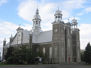
Saint-Cyrille-de-Wendover is a Quebec municipality located in the Drummond Regional County Municipality just east of Drummondville in the Centre-du-Quebec region. The population as of the Canada 2011 Census was 4,389. The town is located alongside the Rivière des Saults.

Saint-Anaclet-de-Lessard is a parish municipality in the Canadian province of Quebec, located in the Rimouski-Neigette Regional County Municipality.

Saint-Lambert-de-Lauzon is a municipality in La Nouvelle-Beauce Regional County Municipality in Quebec, Canada. It is part of the Chaudière-Appalaches region and the population is 6,177 as of the Canada 2011 Census. Prior to June 22, 2013 it was a parish municipality.

Sainte-Marie is a city in the province of Quebec. It is the seat of the Municipalité régionale de la Nouvelle-Beauce, in Chaudière-Appalaches. The population was 12,889 as of the Canada 2011 Census, and was 99.0% French-speaking as of 2006. It is located 59 kilometres (37 mi) south-east of Quebec City, on the Chaudière River.

Sainte-Luce is a municipality in the La Mitis Regional County Municipality in the Bas-Saint-Laurent region of Quebec, Canada. The population in the Canada 2011 Census was 2,851.

Les Éboulements is a municipality in the Capitale-Nationale region of Quebec, Canada.

Saint-Just-de-Bretenières is a municipality in Quebec. It is located on the Canada–United States border.


