Saint-Eugène-de-Guigues

Last updated • 1 min readFrom Wikipedia, The Free Encyclopedia

Saint-Eugène-de-Guigues
St-Eugene-de-Guigues QC.jpg
Downtown of Saint-Eugène-de-Guigues
Motto: 
S'Unir pour Grandir
Saint-Eugene-de-Guigues Quebec location diagram.png
Location within Témiscamingue RCM
Canada Western Quebec location map.png
Red pog.svg
St-Eugène-de-Guigues
Location in western Quebec
Coordinates: 47°31′N79°21′W / 47.517°N 79.350°W / 47.517; -79.350 [1]
CountryCanada
Province Quebec
Region Abitibi-Témiscamingue
RCM Témiscamingue
Settled1911
ConstitutedNovember 20, 1912
Government
[2]
  MayorMarco Dénommé
   Federal riding Abitibi—Témiscamingue
   Prov. riding Rouyn-Noranda–Témiscamingue
Area
  Total
116.61 km2 (45.02 sq mi)
  Land109.52 km2 (42.29 sq mi)
Population
 (2021) [3]
  Total
458
  Density4.2/km2 (11/sq mi)
  Pop (2016–21)
Decrease2.svg 1.5%
  Dwellings
254
Time zone UTC−05:00 (EST)
  Summer (DST) UTC−04:00 (EDT)
Postal code(s)
Area code 819
Website www.st-eugene-de-guigues.qc.ca OOjs UI icon edit-ltr-progressive.svg

Saint-Eugène-de-Guigues (French pronunciation: [sɛ̃t‿øʒɛnɡiɡ] ) is a municipality in northwestern Quebec, Canada, in the Témiscamingue Regional County Municipality.

Contents

History

In 1881, the geographic township of Guigues was proclaimed, named in honour of Joseph-Eugène-Bruno Guigues. [4] In 1897, it was incorporated as the Township Municipality of Guigues.

In 1911, the parish of Saint-Eugène-de-Guigues was founded, and the following year, the Municipality of Saint-Eugène-de-Guigues was created when it split off from the township. [1]

Demographics

Canada census – Saint-Eugène-de-Guigues community profile
2021 2016 2011
Population458 (-1.5% from 2016)465 (+2.4% from 2011)454 (-4.2% from 2006)
Land area109.52 km2 (42.29 sq mi)110.02 km2 (42.48 sq mi)110.34 km2 (42.60 sq mi)
Population density4.2/km2 (11/sq mi)4.2/km2 (11/sq mi)4.1/km2 (11/sq mi)
Median age42.8 (M: 43.2, F: 42.0)38.7 (M: 38.9, F: 38.5)43.2 (M: 43.4, F: 41.9)
Private dwellings254 (total)  198 (occupied)286 (total)  190 (occupied)185 (total)  182 (occupied)
Median household income$71,000$56,960$54,099
References: 2021 [5] 2016 [6] 2011 [7] earlier [8] [9]
Historical census populations – Saint-Eugène-de-Guigues
YearPop.±%
1921 564    
1931 939+66.5%
1941 952+1.4%
1951 750−21.2%
1956 873+16.4%
1961 878+0.6%
YearPop.±%
1966 890+1.4%
1971 662−25.6%
1976 518−21.8%
1981 506−2.3%
1986 473−6.5%
1991 415−12.3%
YearPop.±%
1996 423+1.9%
2001 439+3.8%
2006 474+8.0%
2011 454−4.2%
2016 465+2.4%
2021 458−1.5%
Population counts are not adjusted for boundary changes.
Source: Statistics Canada [3] [10]

Mother tongue (2021): [3]

Government

List of former mayors:

See also

Related Research Articles

<span class="mw-page-title-main">Bonaventure, Quebec</span> City in Quebec, Canada

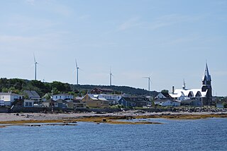
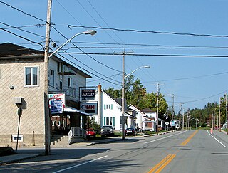
Bonaventure is a town on the Gaspé Peninsula in the Bonaventure Regional County Municipality of Quebec. It is located on Chaleur Bay near the mouth of the Bonaventure River. The town is situated on Route 132 between Saint-Siméon and New Carlisle.

<span class="mw-page-title-main">Saint-Eugène-d'Argentenay</span> Municipality in Quebec, Canada

Saint-Eugène-d'Argentenay is a municipality in the Canadian province of Quebec, located within the regional county municipality of Maria-Chapdelaine. The municipality had a population of 487 as of the Canada 2021 Census. Prior to 1997 it was known simply as Saint-Eugène.

<span class="mw-page-title-main">Baie-des-Sables</span> Municipality in Quebec, Canada

Baie-des-Sables is a municipality in La Matanie Regional County Municipality in the Bas-Saint-Laurent region of Quebec, Canada.

<span class="mw-page-title-main">Joseph-Bruno Guigues</span>

Joseph-Eugène-Bruno Guigues was an Oblate priest, a teacher and became the first bishop of the diocese of Bytown (Ottawa) serving from (1847–1874). His consecration service in 1848 was performed by Rémi Gaulin, bishop of Kingston.

<span class="mw-page-title-main">La Pêche</span> Municipality in Quebec, Canada

La Pêche is a municipality along both sides of the Gatineau River in Les Collines-de-l'Outaouais Regional County Municipality in the Outaouais region of Quebec, Canada, about 30 km (19 mi) north of downtown Gatineau.

<span class="mw-page-title-main">Duhamel-Ouest</span> Municipality in Quebec, Canada

Duhamel-Ouest is a municipality in northwestern Quebec, Canada in the Témiscamingue Regional County Municipality.

<span class="mw-page-title-main">Fugèreville</span> Municipality in Quebec, Canada

Fugèreville is a municipality in northwestern Quebec, Canada in the Témiscamingue Regional County Municipality.

<span class="mw-page-title-main">Angliers, Quebec</span> Former village municipality in Quebec, Canada

Angliers is a former village municipality in northwestern Quebec, Canada, in the Témiscamingue Regional County Municipality. It is one of the two sectors in the municipality of Laverlochère-Angliers.

<span class="mw-page-title-main">Saint-Bruno-de-Guigues</span> Municipality in Quebec, Canada

Saint-Bruno-de-Guigues, often shortened to Guigues, is a municipality in northwestern Quebec, Canada, in the Témiscamingue Regional County Municipality.

<span class="mw-page-title-main">Guérin, Quebec</span> Township municipality in Quebec, Canada

Guérin is a township municipality in northwestern Quebec, Canada, in the Témiscamingue Regional County Municipality.

<span class="mw-page-title-main">Latulipe-et-Gaboury</span> United township municipality in Quebec, Canada

Latulipe-et-Gaboury is a united township municipality in northwestern Quebec, Canada, in the Témiscamingue Regional County Municipality. The only other remaining united township municipality in Quebec is Stoneham-et-Tewkesbury.

<span class="mw-page-title-main">Saint-Édouard-de-Fabre</span> Parish municipality in Quebec, Canada

Saint-Édouard-de-Fabre is a parish municipality in western Quebec, Canada, in the Témiscamingue Regional County Municipality.

<span class="mw-page-title-main">Lochaber, Quebec</span> Township municipality in Quebec, Canada

Lochaber is a township municipality in the Canadian province of Quebec, located within the Papineau Regional County Municipality. The township had a population of 415 in the 2016 Canadian Census.

<span class="mw-page-title-main">Hope, Quebec</span> Township municipality in Quebec, Canada

Hope is a township municipality in the Canadian province of Quebec, located within the Bonaventure Regional County Municipality. Its population was 584 in the 2021 Canadian census.

<span class="mw-page-title-main">Saint-Godefroi</span> Township municipality in Quebec, Canada

Saint-Godefroi is a township municipality in the Canadian province of Quebec, located within the Bonaventure Regional County Municipality. The township had a population of 350 in the 2021 Canadian census.

<span class="mw-page-title-main">Laniel, Quebec</span> Unorganized territory in Quebec, Canada

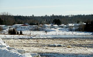
Laniel is an unorganized territory in the Témiscamingue Regional County Municipality, Abitibi-Témiscamingue region, Quebec, Canada. It surrounds the northern portion of Lake Kipawa.

<span class="mw-page-title-main">Sainte-Anne-du-Lac</span> Municipality in Quebec, Canada

Sainte-Anne-du-Lac is a municipality and village in the Laurentides region of Quebec, Canada, part of the Antoine-Labelle Regional County Municipality.

<span class="mw-page-title-main">Saint-Eugène, Quebec</span> Municipality in Quebec, Canada

Saint-Eugène is a municipality in the Centre-du-Québec region of Quebec. The population as of the Canada 2021 Census was 1,139.

<span class="mw-page-title-main">Lac-Saint-Paul, Quebec</span> Municipality in Quebec, Canada

Lac-Saint-Paul is a municipality in the Laurentides region of Quebec, Canada, part of the Antoine-Labelle Regional County Municipality.

<span class="mw-page-title-main">Mont-Saint-Michel, Quebec</span> Municipality in Quebec, Canada

Mont-Saint-Michel is a municipality in the Laurentides region of Quebec, Canada, part of the Antoine-Labelle Regional County Municipality.

References

  1. 1 2 "Banque de noms de lieux du Québec: Reference number 56471". toponymie.gouv.qc.ca (in French). Commission de toponymie du Québec.
  2. 1 2 "Répertoire des municipalités: Geographic code 85085". www.mamh.gouv.qc.ca (in French). Ministère des Affaires municipales et de l'Habitation. Retrieved 2023-12-05.
  3. 1 2 3 4 "Saint-Eugène-de-Guigues (Code 2485085) Census Profile". 2021 census . Government of Canada - Statistics Canada . Retrieved 2023-12-05.
  4. "Banque de noms de lieux du Québec: Guigues (canton)". toponymie.gouv.qc.ca (in French). Commission de toponymie du Québec . Retrieved 2023-12-07.
  5. "2021 Community Profiles". 2021 Canadian census . Statistics Canada. February 4, 2022. Retrieved 2023-12-04.
  6. "2016 Community Profiles". 2016 Canadian census . Statistics Canada. August 12, 2021. Retrieved 2024-12-24.
  7. "2011 Community Profiles". 2011 Canadian census . Statistics Canada. March 21, 2019. Retrieved 2024-12-24.
  8. "2006 Community Profiles". 2006 Canadian census . Statistics Canada. August 20, 2019.
  9. "2001 Community Profiles". 2001 Canadian census . Statistics Canada. July 18, 2021.
  10. 1996, 2001, 2006, 2011 census