Notre-Dame-du-Nord

Last updated • 2 min readFrom Wikipedia, The Free Encyclopedia

Notre-Dame-du-Nord
Notre-Dame-du-Nord QC.jpg
Lake Timiskaming waterfront
Notre-Dame-du-Nord Quebec location diagram.png
Location within Témiscamingue RCM
Canada Western Quebec location map.png
Red pog.svg
Notre-Dame-du-Nord
Location in western Quebec
Coordinates: 47°36′N79°29′W / 47.600°N 79.483°W / 47.600; -79.483 [1]
CountryCanada
Province Quebec
Region Abitibi-Témiscamingue
RCM Témiscamingue
Settled1896
ConstitutedSeptember 23, 1919
Government
[2]
  MayorNico Gervais
   Federal riding Abitibi—Témiscamingue
   Prov. riding Rouyn-Noranda–Témiscamingue
Area
  Total
89.92 km2 (34.72 sq mi)
  Land74.34 km2 (28.70 sq mi)
Population
 (2021) [3]
  Total
1,090
  Density14.7/km2 (38/sq mi)
  Pop (2016–21)
Increase2.svg 3.6%
  Dwellings
569
Time zone UTC−05:00 (EST)
  Summer (DST) UTC−04:00 (EDT)
Postal code(s)
Area code 819
HighwaysQc101.svg R-101
Website nddn.ca OOjs UI icon edit-ltr-progressive.svg

Notre-Dame-du-Nord (French pronunciation: [nɔtʁədamdynɔʁ] ) is a municipality in the Canadian province of Quebec, located in the Témiscamingue Regional County Municipality. It is located at the northern end of Lake Timiskaming where the Ottawa River enters into this lake.

Contents

The municipality is located along Route 101. A local street, rue Ontario, extends westward from Route 101 to the Quebec-Ontario border, where it becomes Ontario Highway 65. In Ontario, the highway passes through the townships of Casey and Harris en route to the city of Temiskaming Shores.

Notre-Dame-du-Nord is best known as the home of an annual truck drag race event called Rodéo du Camion (Truck Rodeo) which is held over the August Civic Holiday of each year, which brings over 650 trucks and 60,000 spectators to the town each year.

Local attractions also include the Lake Timiskaming Fossil Centre, a museum and research institution dedicated to the fossils of the Témiscamingue region, and the Heath Racing motocross track.

History

Intersection of Route 101 and Rue Ontario, with Lake Timiskaming in the background Notre-Dame-du-Nord.jpg
Intersection of Route 101 and Rue Ontario, with Lake Timiskaming in the background

The area had been known by a variety of names: Tête-du-Lac ("Head-of-the-Lake" in reference to its position at the head of Lake Timiskaming), Pointe à Polson in 1858 (after a First Nations family living there at the time), Murray City in 1862 (in honour of Thomas Murray of Pembroke whose company was logging there), and North Temiscaming at the end of 19th century. [1]

In 1895, the mission located on the north bank of the Rapids des Quinze became a parish under the name of Notre-Dame-du-Nord. In 1919, the place was incorporated as the Township Municipality of Nedelec-Partie-Sud. It was partially destroyed in the Great Fire of 1922. In 1928, it was renamed after the parish. [1] [4]

In 1951, the Municipality of Notre-Dame-des-Quinze, which had developed concurrently on the other side of the rapids, was merged into Notre-Dame-du-Nord. [4]

Demographics

Canada census – Notre-Dame-du-Nord community profile
2021 2016 2011
Population1,090 (+3.6% from 2016)1,052 (-2.1% from 2011)1,075 (-3.7% from 2006)
Land area74.34 km2 (28.70 sq mi)74.76 km2 (28.86 sq mi)74.99 km2 (28.95 sq mi)
Population density14.7/km2 (38/sq mi)14.1/km2 (37/sq mi)14.3/km2 (37/sq mi)
Median age54.4 (M: 53.2, F: 55.6)49.9 (M: 50.0, F: 49.9)48.5 (M: 48.0, F: 49.0)
Private dwellings569 (total)  511 (occupied)536 (total)  490 (occupied)534 (total)  514 (occupied)
Median household income$58,000$47,360$49,260
References: 2021 [5] 2016 [6] 2011 [7] earlier [8] [9]
Historical census populations – Notre-Dame-du-Nord
YearPop.±%
1921 464    
1931 443−4.5%
1941 422−4.7%
1951 589+39.6%
1956 1,146+94.6%
1961 1,154+0.7%
YearPop.±%
1966 1,182+2.4%
1971 1,250+5.8%
1976 1,260+0.8%
1981 1,311+4.0%
1986 1,284−2.1%
1991 1,245−3.0%
YearPop.±%
1996 1,250+0.4%
2001 1,109−11.3%
2006 1,116+0.6%
2011 1,075−3.7%
2016 1,052−2.1%
2021 1,090+3.6%
Population counts are not adjusted for boundary changes.
Source: Statistics Canada [3] [10]

Mother tongue (2021): [3]

Government

List of former mayors:

See also

Related Research Articles

<span class="mw-page-title-main">Abitibi-Ouest Regional County Municipality</span> Regional county municipality in Quebec, Canada

Abitibi-Ouest Regional County Municipality is a regional county municipality located in the Abitibi-Témiscamingue region of Quebec. Its seat is La Sarre.

<span class="mw-page-title-main">Temiskaming Shores</span> City in Ontario, Canada

Temiskaming Shores is a city in the Timiskaming District in Northeastern Ontario, Canada. It was created by the amalgamation of the town of New Liskeard, the town of Haileybury, and the township of Dymond in 2004. The city had a total population of 9,634 in the Canada 2021 Census. Temiskaming Shores is Ontario's second-smallest city, in terms of population, after Dryden. Haileybury is the seat of Timiskaming District.

<span class="mw-page-title-main">Témiscamingue Regional County Municipality</span> Regional county municipality in Quebec, Canada

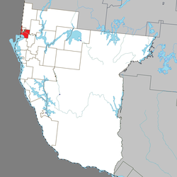
Témiscamingue is a regional county municipality in the Abitibi-Témiscamingue region of western Quebec, Canada. The county seat is Ville-Marie.

<span class="mw-page-title-main">Fassett, Quebec</span> Municipality in Quebec, Canada

Fassett is a municipality and village in the Papineau Regional County Municipality in Quebec, Canada, located on the north shore of the Ottawa River east of Montebello.

<span class="mw-page-title-main">Témiscaming</span> City in Quebec, Canada

Témiscaming is a city located at the south end of Lac Témiscamingue on the upper Ottawa River in the Témiscamingue Regional County Municipality of western Quebec, Canada. Also nearby is Lake Kipawa.

<span class="mw-page-title-main">Notre-Dame-du-Mont-Carmel, Quebec</span> Parish municipality in Quebec, Canada

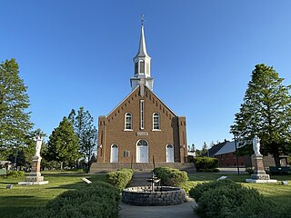
Notre-Dame-du-Mont-Carmel is a parish municipality in the Mauricie region of the province of Quebec in Canada.

<span class="mw-page-title-main">Timiskaming First Nation</span> First Nations reserve in Quebec, Canada

Timiskaming is a First Nations reserve in the Abitibi-Témiscamingue region of Quebec, Canada, just north of the head of Lake Timiskaming. It belongs to the Timiskaming First Nation, an Algonquin band. It is geographically within the Témiscamingue Regional County Municipality but administratively not part of it.

<span class="mw-page-title-main">Duhamel-Ouest</span> Municipality in Quebec, Canada

Duhamel-Ouest is a municipality in northwestern Quebec, Canada in the Témiscamingue Regional County Municipality.

<span class="mw-page-title-main">Fugèreville</span> Municipality in Quebec, Canada

Fugèreville is a municipality in northwestern Quebec, Canada in the Témiscamingue Regional County Municipality.

<span class="mw-page-title-main">Kipawa, Quebec</span> Municipality in Quebec, Canada

Kipawa is a village and municipality in western Quebec, Canada, in the Témiscamingue Regional County Municipality. It is located at the south end of Lake Kipawa, adjacent to the Kebaowek Reserve. In addition to the community of Kipawa itself located on the namesake lake, the municipality also includes the community of Tee Lake, and surrounds the Indian Reserve of Kebaowek.

<span class="mw-page-title-main">Lorrainville</span> Municipality in Quebec, Canada

Lorrainville is a municipality in northwestern Quebec, Canada, in the Témiscamingue Regional County Municipality.

<span class="mw-page-title-main">Rémigny, Quebec</span> Municipality in Quebec, Canada

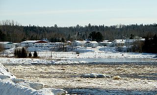
Rémigny is a municipality in northwestern Quebec, Canada, in the Témiscamingue Regional County Municipality. The town centre is located along the Barrière River.

<span class="mw-page-title-main">Saint-Bruno-de-Guigues</span> Municipality in Quebec, Canada

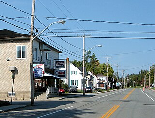
Saint-Bruno-de-Guigues, often shortened to Guigues, is a municipality in northwestern Quebec, Canada, in the Témiscamingue Regional County Municipality.

<span class="mw-page-title-main">Nédélec</span> Township municipality in Quebec, Canada

Nédélec is a township municipality in western Quebec, Canada, in the Témiscamingue Regional County Municipality.

<span class="mw-page-title-main">Saint-Édouard-de-Fabre</span> Parish municipality in Quebec, Canada

Saint-Édouard-de-Fabre is a parish municipality in western Quebec, Canada, in the Témiscamingue Regional County Municipality.

<span class="mw-page-title-main">Notre-Dame-de-Bonsecours</span> Municipality in Quebec, Canada

Notre-Dame-de-Bonsecours is a municipality in the Outaouais region of Quebec, Canada. It is located along the Ottawa River, about 55 kilometres (34 mi) east of Gatineau. It was formerly known as Notre-Dame-de-Bon-Secours-Partie-Nord. It is the least populated municipality in the Papineau Regional County Municipality.

<span class="mw-page-title-main">Notre-Dame-du-Laus</span> Municipality in Quebec, Canada

Notre-Dame-du-Laus is a municipality in the Laurentides region of Quebec, Canada, part of the Antoine-Labelle Regional County Municipality.

<span class="mw-page-title-main">Notre-Dame-de-Pontmain</span> Municipality in Quebec, Canada

Notre-Dame-de-Pontmain is a municipality in the Laurentides region of Quebec, Canada, part of the Antoine-Labelle Regional County Municipality.

<span class="mw-page-title-main">La Doré, Quebec</span> Parish municipality in Quebec, Canada

La Doré is a parish municipality in Quebec, Canada, in the regional county municipality of Le Domaine-du-Roy and the administrative region of Saguenay–Lac-Saint-Jean.

<span class="mw-page-title-main">Des Quinze Lake</span>

The Lac des Quinze is a freshwater body extending into the municipalities of Moffet, Laverlochère-Angliers, Latulipe-et-Gaboury, Quebec, Guérin, and Rémigny in the Témiscamingue (RCM), in the Abitibi-Témiscamingue administrative region, in Quebec, in Canada.

References

  1. 1 2 3 "Notre-Dame-du-Nord (Municipalité)" (in French). Commission de toponymie du Québec. Retrieved 2011-01-02.
  2. 1 2 "Répertoire des municipalités: Geographic code 85090". www.mamh.gouv.qc.ca (in French). Ministère des Affaires municipales et de l'Habitation. Retrieved 2023-12-04.
  3. 1 2 3 4 "Notre-Dame-du-Nord (Code 2485090) Census Profile". 2021 census . Government of Canada - Statistics Canada . Retrieved 2023-12-04.
  4. 1 2 "History of Notre-Dame-du-Nord". Chambre de Commerce de Notre-Dame-du-Nord. Archived from the original on 2011-07-06. Retrieved 2011-01-02.
  5. "2021 Community Profiles". 2021 Canadian census . Statistics Canada. February 4, 2022. Retrieved 2023-12-04.
  6. "2016 Community Profiles". 2016 Canadian census . Statistics Canada. August 12, 2021. Retrieved 2024-12-20.
  7. "2011 Community Profiles". 2011 Canadian census . Statistics Canada. March 21, 2019. Retrieved 2024-12-20.
  8. "2006 Community Profiles". 2006 Canadian census . Statistics Canada. August 20, 2019.
  9. "2001 Community Profiles". 2001 Canadian census . Statistics Canada. July 18, 2021.
  10. 1996, 2001, 2006 census, 2006 Population and dwelling count amendments, 2011 census

Further reading