Saint-Eutrope

Last updated

Saint-Eutrope
Part of Montmoreau
St-Eutrope 16 Mairie 2 2012.jpg
Town hall
Location of Saint-Eutrope
Saint-Eutrope
France location map-Regions and departements-2016.svg
Red pog.svg
Saint-Eutrope
Aquitaine-Limousin-Poitou-Charentes region location map.svg
Red pog.svg
Saint-Eutrope
Coordinates: 45°25′08″N0°06′44″E / 45.4189°N 0.1122°E / 45.4189; 0.1122 Coordinates: 45°25′08″N0°06′44″E / 45.4189°N 0.1122°E / 45.4189; 0.1122
Country France
Region Nouvelle-Aquitaine
Department Charente
Arrondissement Angoulême
Canton Tude-et-Lavalette
Commune Montmoreau
Area
1
2.67 km2 (1.03 sq mi)
Population
 (2018) [1]
168
  Density63/km2 (160/sq mi)
Time zone UTC+01:00 (CET)
  Summer (DST) UTC+02:00 (CEST)
Postal code
16190
Elevation114–186 m (374–610 ft)
(avg. 183 m or 600 ft)
1 French Land Register data, which excludes lakes, ponds, glaciers > 1 km2 (0.386 sq mi or 247 acres) and river estuaries.

Saint-Eutrope is a former commune in the Charente department in southwestern France. On 1 January 2017, it was merged into the new commune Montmoreau. [2]

Contents

Geography

16 Rue principale 2012 St-Eutrope 16 Rue principale 2012.jpg
16 Rue principale 2012
view of St Eutrope Stamant vue3.JPG
view of St Eutrope

Saint-Eutrope is a common South Charente located 2.5 km northwest of Montmoreau and 26 km south of Angoulême. It is a small town on the surface (less than 3 km2), and lying territory (3.5 km long and 0.5 km wide).

The village is 9 km southeast of Blanzac.

The town is crossed by two county roads. The main one is the D 10, drive to Montmoreau Blanzac and Chateauneuf, which runs through the town staying on the ridge. The other is the D 74 which joins the road to Angoulême Libourne (D 674) by Saint-Cybard and part of the town. It is also the route of Nonac in North Western Canada.2.

The nearest train station is in Montmoreau, served by TER to Angoulême and Bordeaux.

Hamlets and localities

The village is quite large, and the town hamlets are small and are only farms: Bel-Air, Large Stones, Maine Blanchard, in Calais, Perry. Chabreville Castle, not far from the town, is in the municipality of Courgeac.

Geology

The ground is limestone Cretaceous (chalk), but the peaks are covered with sand and clay tertiary deposit, and wood (or heath) have chestnuts and pines, calcifuges species.

The clay of the ground meant that Saint-Eutrope was a renowned place of manufacture of solid pottery until the 20th century, there was also an iron mine [3]

History

In the early sixteenth century, St. Eutrope de la Lande was a priory. [4] A Romanesque church dates from the twelfth century.

St. Eutropius was in the manor of Montmoreau dependent Angoumois, and following the religious wars, Francis has installed persecuted Catholic families, as well as Saint-Laurent-de-Belzagot. [5]

Saint-Eutrope has long been famous for its pottery. In the eighteenth century, no fewer than 30 families working there, with 25 fours. Saint-Eutrope specialized in the manufacture of large pieces: mass graves, Ponnes and flagons, as well as "faience pebbles" yellow glaze characteristics of certain workshops in the locality. This craft has reached its peak in 1841 with 140 potters. After the 1914–18 war, they were only a dizaine. [6]

The clay was then briefly operated as a building material (brickworks in Bel-Air, adopted in 1986).

Name

The first mention of the place appears in 1523: Sanctus Eutropius of Landa. [7] Saint Eutrope was the first bishop of Saintes, and his relics were the subject of pilgrimages in the Middle age. [8]

During the French Revolution, Saint-Eutrope was called La Poterie, and Utrope.

Dialects

Although the dialectal limit is 10 km to the east, the town also has the distinction of being a small enclave Occitan (Limousin dialect) language of oïl. [9] [10]

Population

Historical population
YearPop.±% p.a.
1793282    
1800228−2.99%
1806274+3.11%
1821279+0.12%
1831297+0.63%
1841292−0.17%
1846306+0.94%
1851306+0.00%
1856258−3.35%
1861262+0.31%
1866242−1.58%
1872201−3.05%
1876194−0.88%
1881196+0.21%
1886200+0.40%
1891210+0.98%
1896202−0.77%
YearPop.±% p.a.
1901195−0.70%
1906202+0.71%
1911192−1.01%
1921174−0.98%
1926187+1.45%
1931159−3.19%
1936146−1.69%
1946142−0.28%
1954173+2.50%
1962157−1.21%
1968137−2.25%
1975164+2.60%
1982164+0.00%
1990192+1.99%
1999169−1.41%
2007157−0.92%
2012179+2.66%
Source: EHESS [11] and INSEE (2007–2012) [12]

See also

Related Research Articles

Charente Department of France

Charente is a department in the administrative region of Nouvelle-Aquitaine, western France. It is named after the river Charente, the most important river in the department, and also the river beside which the department's two largest towns, Angoulême and Cognac, are sited. The Charente is the longest river in the Charente department.

Communes of the Charente-Maritime department

The following is a list of the 463 communes of the Charente-Maritime department of France.

Aubeterre-sur-Dronne Commune in Nouvelle-Aquitaine, France

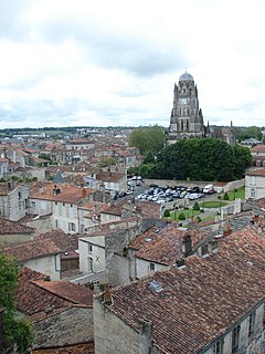
Aubeterre-sur-Dronne, commonly referred to as Aubeterre, is a commune in the Charente department in the Nouvelle-Aquitaine region of Southwestern France. In 2017, it had a population of 386. Its inhabitants are known as Aubeterriens (masculine) or Aubeterriennes (feminine).

Saintes, Charente-Maritime Subprefecture and commune in Nouvelle-Aquitaine, France

Saintes is a commune and historic town in western France, in the Charente-Maritime department of which it is a sub-prefecture, in Nouvelle-Aquitaine. Its inhabitants are called Saintaises and Saintais. Saintes is the second-largest city in Charente-Maritime, with 26,470 inhabitants in 2008. The city's immediate surroundings form the second-most populous metropolitan area in the department, with 56,598 inhabitants. While a majority of the surrounding landscape consists of fertile, productive fields, a significant minority of the region remains forested, its natural state.

County of Saintonge French province (1371–1790)

The County of Saintonge, historically spelled Xaintonge and Xainctonge, is a former province of France located on the west central Atlantic coast. The capital city was Saintes. Other principal towns include Saint-Jean-d'Angély, Jonzac, Frontenay-Rohan-Rohan, Royan, Marennes, Pons, and Barbezieux-Saint-Hilaire.

Aunis Place in France

Aunis is a historical province of France, situated in the north-west of the department of Charente-Maritime. Its historic capital is La Rochelle, which took over from Castrum Allionis (Châtelaillon) the historic capital which gives its name to the province.

Arrondissement of Angoulême Arrondissement in Nouvelle-Aquitaine, France

The arrondissement of Angoulême is an arrondissement of France in the Charente department in the Nouvelle-Aquitaine region. It has 115 communes. Its population is 181,456 (2016), and its area is 1,867.6 km2 (721.1 sq mi).

Arrondissement of Cognac Arrondissement in Nouvelle-Aquitaine, France

The arrondissement of Cognac is an arrondissement of France in the Charente department in the Nouvelle-Aquitaine region. It has 108 communes. Its population is 99,987 (2016), and its area is 1,670.8 km2 (645.1 sq mi).

Aigrefeuille-dAunis Commune in Nouvelle-Aquitaine, France

Aigrefeuille-d'Aunis is a commune in the Charente-Maritime department in the Nouvelle-Aquitaine region of south-western France.

Agudelle Commune in Nouvelle-Aquitaine, France

Agudelle is a commune in the Charente-Maritime department in the Nouvelle-Aquitaine region of southwestern France.

Château de Marthon

The Château de Marthon is a ruined castle in the commune of Marthon in the Charente département of France. Only the keep remains.

Château de Montignac

The Château de Montignac is a ruined castle in the commune of Montignac-Charente, in the Charente département of France. The castle is the property of the commune and has been listed since 1962 as a monument historique by the French Ministry of Culture.

Aignes-et-Puypéroux Part of Montmoreau in Nouvelle-Aquitaine, France

Aignes-et-Puypéroux is a former commune in the Charente department in the Nouvelle-Aquitaine region of southwestern France. On 1 January 2017, it was merged into the new commune Montmoreau.

Ambleville, Charente Part of Lignières-Ambleville in Nouvelle-Aquitaine, France

Ambleville is a former commune in the Charente department in the Nouvelle-Aquitaine region of southwestern France. On 1 January 2022, it was merged into the new commune of Lignières-Ambleville.

Baignes-Sainte-Radegonde Commune in Nouvelle-Aquitaine, France

Baignes-Sainte-Radegonde is a commune in the Charente department in the Nouvelle-Aquitaine region of south-western France.

Balzac, Charente Commune in Nouvelle-Aquitaine, France

Balzac is a commune in the Charente department in the Nouvelle-Aquitaine region of south-western France.

Brie, Charente Commune in Nouvelle-Aquitaine, France

Brie is a commune in the Charente department in southwestern France.

Aulnay, Charente-Maritime Commune in Nouvelle-Aquitaine, France

Aulnay, commonly referred to as Aulnay-de-Saintonge, is a commune in the Charente-Maritime department in the Nouvelle-Aquitaine region of south-western France.

Lozay Commune in Nouvelle-Aquitaine, France

Lozay is a commune in the Charente-Maritime department in southwestern France.

Montmoreau Commune in Nouvelle-Aquitaine, France

Montmoreau is a commune in the department of Charente, southwestern France. The municipality was established on 1 January 2017 by merger of the former communes of Montmoreau-Saint-Cybard, Aignes-et-Puypéroux, Saint-Amant-de-Montmoreau, Saint-Eutrope and Saint-Laurent-de-Belzagot.

References

  1. Téléchargement du fichier d'ensemble des populations légales en 2018, INSEE
  2. Arrêté préfectoral 29 June 2016 (in French)
  3. Jules Martin-Buchey, Géographie historique et communale de la Charente, édité par l'auteur, Châteauneuf, 1914–1917 (réimpr. Bruno Sépulchre, Paris, 1984), 422 p., p. 327
  4. Archives historiques de la Saintonge et de l'Aunis, Volume 35, (par Société des archives historiques de la Saintonge et de l'Aunis, 1905), p. 44
  5. Jean-Hippolyte Michon, Statistique monumentale de la Charente, Paris, Derache (réimprimé en 1980 par Bruno Sépulchre, (Paris), 1844), p334
  6. Jules Martin-Buchey, Géographie historique et communale de la Charente, édité par l'auteur, Châteauneuf, 1914–1917 (réimpr. Bruno Sépulchre, Paris, 1984), 422 p., p. 327
  7. Archives historiques de la Saintonge et de l'Aunis, Volume 35, (par Société des archives historiques de la Saintonge et de l'Aunis, 1905), p. 44
  8. Joël Guitton et al., Les chemins de Saint-Jacques en Charente, éditions Sud Ouest, 2010, p254.
  9. La langue occitane, Pierre Bec, Que sais-je, p. 11 : « Le village de St-Eutrope enfin (départ. Charente, entre Ribérac et Angoulême) forme une enclave limousine en domaine français. »
  10. Une colonie limousine en Saintonge, Saint-Eutrope, par Anatole Boucherie (éd. Maisonneuve, 1876)
  11. Des villages de Cassini aux communes d'aujourd'hui: Commune data sheet Saint-Eutrope, EHESS. (in French)
  12. Populations légales 2012, INSEE