Saint-Louis-de-Gonzague-du-Cap-Tourmente

Last updated
Saint-Louis-de-Gonzague-
du-Cap-Tourmente
Seminaire de Quebec Petit Cap 02.jpg
Saint-Louis-de-Gonzague-du-Cap-Tourmente Quebec location diagram.png
Location within La Côte-de-Beaupré RCM.
Canada Central Quebec location map.png
Red pog.svg
St-Louis-de-Gonzague-du-Cap-Tourmente
Location in central Quebec
Coordinates: 47°04′N70°50′W / 47.067°N 70.833°W / 47.067; -70.833 Coordinates: 47°04′N70°50′W / 47.067°N 70.833°W / 47.067; -70.833 [1]
CountryFlag of Canada (Pantone).svg  Canada
Province Flag of Quebec.svg  Quebec
Region Capitale-Nationale
RCM La Côte-de-Beaupré
ConstitutedJanuary 1, 1917
Government
[2]
  AdministratorJacques Roberge
   Federal riding Montmorency—Charlevoix
—Haute-Côte-Nord
   Prov. riding Charlevoix–Côte-de-Beaupré
Area
  Total7.90 km2 (3.05 sq mi)
  Land0.42 km2 (0.16 sq mi)
Population
 (2021) [4]
  Total0
  Density0/km2 (0/sq mi)
  Pop 2016-2021
Decrease2.svg 100%
  Dwellings
1
Time zone UTC−5 (EST)
  Summer (DST) UTC−4 (EDT)
Postal code(s)
Area code(s) 418 and 581
HighwaysQc138.svg Route 138

Saint-Louis-de-Gonzague-du-Cap-Tourmente is a parish municipality in Quebec, Canada.

Contents

Its population in the Canada 2021 Census was 0. [4] It is a relic of the seigneurial system of New France. [1]

Geography

Saint-Louis-de-Gonzague-du-Cap-Tourmente is a small enclave within the municipality of Saint-Joachim, at the foot of Cape Tourmente, and east of Sainte-Anne-de-Beaupré, in the regional county municipality of La Côte-de-Beaupré in the region of Capitale-Nationale.

Located near the provincial capital of Quebec City, it is part of the Communauté métropolitaine de Québec.

History

Named for Saint Aloysius Gonzaga and Cap Tourmente, a stormy promontory named by Samuel de Champlain, the municipality was set up in 1917 by a law that detached certain buildings and lands belonging to the Séminaire de Québec from the parish of Saint-Joachim in order to avoid paying municipal taxes and fees. At that time, it had an area of several square kilometres, including farmland; however, the law specified that if the Séminaire sold any of its property, it would revert to Saint-Joachim. [1]

By and by, all of the Séminaire's property was sold and was thereby returned to Saint-Joachim, except for the Petit-Cap property, which now constitutes the entire territory of the municipality.

Government

The municipality is not governed by a municipal council but by the Board of Directors of the Séminaire de Québec. As such, it does not have a mayor but rather an administrator. [2]

Demographics

In the 2011 Census, Statistics Canada originally reported that Saint-Louis-de-Gonzague-du-Cap-Tourmente had a population of 18 living in 8 of its 12 total dwellings, an increase from its 2006 population of 0. [5] Statistics Canada subsequently amended the 2011 census results to a population of 5 living in 1 dwelling. [4] With a land area of 0.35 km2 (0.14 sq mi), it had a population density of

Population trend: [6]

See also

Related Research Articles

LIsle-aux-Coudres Municipality in Quebec, Canada

L'Isle-aux-Coudres is a municipality in Quebec, Canada, in the Charlevoix Regional County Municipality in the Charlevoix area of the Capitale-Nationale region. It is located on and contiguous with Coudres Island, located in the St. Lawrence River about 6 kilometres (3.7 mi) south from the mainland.

Sainte-Anne-de-Beaupré City in Quebec, Canada

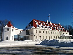
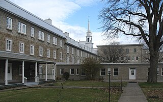
Sainte-Anne-de-Beaupré is a town in La Côte-de-Beaupré Regional County Municipality, Quebec, Canada, along the Saint Lawrence River, 35 kilometers (22 mi) north-east of Quebec City. The population was 2,803 according to the Canada 2006 Census. Major religious landmarks, the Basilica of Sainte-Anne-de-Beaupré and the Convent of the Redemptoristines, are located in the town. The basilica continues to attract pilgrims.

Notre-Dame-des-Anges, Quebec Parish municipality in Quebec, Canada

Notre-Dame-des-Anges is a parish municipality in Quebec, Canada, home of the General Hospital of Quebec.

Château-Richer City in Quebec, Canada

Château-Richer is a small town situated in the Capitale-Nationale region of Quebec, Canada. Located on the north shore of the Saint Lawrence River east of Quebec City, Château-Richer is the seat for the Côte-de-Beaupré Regional County Municipality.

Péribonka Municipality in Quebec, Canada

Péribonka is a municipality in the Canadian province of Quebec, located in the Maria-Chapdelaine Regional County Municipality. It is situated at the mouth of the Peribonka River where it forms a bay on the north shore of Lac Saint-Jean.

Béarn, Quebec Municipality in Quebec, Canada

Béarn is a municipality in northwestern Quebec, Canada in the Témiscamingue Regional County Municipality.

Saint-Édouard-de-Fabre Parish municipality in Quebec, Canada

Saint-Édouard-de-Fabre is a parish municipality in western Quebec, Canada, in the Témiscamingue Regional County Municipality.

Beaupré, Quebec City in Quebec, Canada

Beaupré is a ville in the Canadian province of Quebec, located in La Côte-de-Beaupré Regional County Municipality. The town is along the Saint Lawrence River and Route 138 at the mouth of the Sainte-Anne-du-Nord River.

Saint-Louis-de-Gonzague, Quebec (parish) Parish municipality in Quebec, Canada

Saint-Louis-de-Gonzague is a parish municipality in the Beauharnois-Salaberry Regional County Municipality in the Montérégie region of Quebec, Canada. The population as of the Canada 2011 Census was 1,389.

Saint-Siméon, Quebec (municipality) Municipality in Quebec, Canada

Saint-Siméon is a municipality in the Charlevoix-Est Regional County Municipality of Quebec, Canada. Founded in 1869, it was named after Saint Simeon of Jerusalem.

Petite-Rivière-Saint-François Municipality in Quebec, Canada

Petite-Rivière-Saint-François is a municipality in Quebec, Canada, along the Saint Lawrence River. It is considered the gateway to the Charlevoix region.

Saint-Tite-des-Caps Municipality in Quebec, Canada

Saint-Tite-des-Caps is a municipality in La Côte-de-Beaupré Regional County Municipality in Quebec, Canada. Located on Route 138 to Baie-Saint-Paul, this road climbs up sharply to about 700 meters (2,300 ft) to reach the town nestled in a valley. The Sainte-Anne-du-Nord River forms the municipal western boundary.

Saint-Ferréol-les-Neiges Municipality in Quebec, Canada

Saint-Ferréol-les-Neiges is a municipality in Quebec, Canada.

Saint-Joachim, Quebec Parish municipality in Quebec, Canada

Saint-Joachim is a parish municipality in Quebec, Canada. It is part of the La Côte-de-Beaupré Regional County Municipality in the Capitale-Nationale region. Located at the foot of Cape Tourmente, it is home to the Cap Tourmente National Wildlife Area and Canyon Sainte-Anne.

Saint-Gabriel-de-Valcartier Municipality in Quebec, Canada

Saint-Gabriel-de-Valcartier is a municipality in the Capitale-Nationale region of Quebec, Canada, located in the Jacques-Cartier River valley. It is home to the Canadian Forces Base Valcartier since World War I.

LAscension-de-Notre-Seigneur, Quebec Parish municipality in Quebec, Canada

L'Ascension-de-Notre-Seigneur is a parish municipality in Quebec, Canada, located within the regional county municipality of Lac-Saint-Jean-Est in the Saguenay-Lac-Saint-Jean region. Its name is French for "the Ascension of Our Lord".

Sault-au-Cochon, Quebec Unorganized territory in Quebec, Canada

Sault-au-Cochon is an unorganized territory in the Capitale-Nationale region of Quebec, Canada, in the La Côte-de-Beaupré Regional County Municipality. It is an unpopulated and undeveloped stretch of shoreline along the Saint Lawrence River that encompasses the promontory from Cape Tourmente to Petite-Rivière-Saint-François.

Carleton-sur-Mer City in Quebec, Canada

Carleton-sur-Mer is the fifth largest town of the Gaspésie's south shore, in southeastern Quebec, Canada, located on Route 132, along Chaleur Bay. It is the seat of the Avignon Regional County Municipality.

References

  1. 1 2 3 "Saint-Louis-de-Gonzague-du-Cap-Tourmente (Municipalité de paroisse)" (in French). Commission de toponymie du Québec. Retrieved 2010-04-27.
  2. 1 2 3 Ministère des Affaires municipales, des Régions et de l'Occupation du territoire - Répertoire des municipalités: Saint-Louis-de-Gonzague-du-Cap-Tourmente
  3. Statistics Canada 2021 Census - Saint-Louis-de-Gonzague-du-Cap-Tourmente census profile
  4. 1 2 3 4 5 "Corrections and updates". Statistics Canada. 2012-09-19. Retrieved 2012-10-13.
  5. 1 2 "Population and dwelling counts, for Canada, provinces and territories, and census subdivisions (municipalities), 2011 and 2006 censuses (Quebec)". Statistics Canada. 2012-02-08. Retrieved 2012-10-13.
  6. Statistics Canada: 1996, 2001, 2006, 2011, 2016, 2021 census

Commons-logo.svg Media related to Saint-Louis-de-Gonzague-du-Cap-Tourmente at Wikimedia Commons