Postojna is a town in the traditional region of Inner Carniola, 35 kilometers (22 mi) from Trieste, in southwestern Slovenia. It is the seat of the Municipality of Postojna. It includes the hamlet of Ravbarkomanda to the northeast.
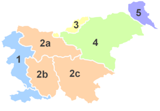
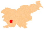
Inner Carniola is a traditional region of Slovenia, the southwestern part of the larger Carniola region. It comprises the Hrušica karst plateau up to Postojna Gate, bordering the Slovenian Littoral in the west. Its administrative and economic center of the region is Postojna, and other minor centers include Vrhnika, Logatec, Cerknica, Pivka, and Ilirska Bistrica.
The Slovene Littoral, or simply Littoral, is one of the traditional regions of Slovenia. The littoral in its name – for a coastal-adjacent area – recalls the former Austrian Littoral, the Habsburg possessions on the upper Adriatic coast, of which the Slovene Littoral was part. Today, the Littoral is often associated with the Slovenian ethnic territory that, in the first half of the 20th century, found itself in Italy to the west of the Rapallo Border, which separated a quarter of Slovenes from the rest of the nation, and was strongly influenced by Italian fascism.
Postojna Cave is a 24.34 km (15.12 mi) long karst cave system near Postojna, southwestern Slovenia. It is the second-longest cave system in the country as well as one of its top tourism sites. The caves were created by the Pivka River.

Brezje pod Nanosom is a small settlement below the eastern slopes of Mount Nanos in the Municipality of Postojna in the Inner Carniola region of Slovenia.

Dilce is a small settlement west of Postojna in the Inner Carniola region of Slovenia. Dilce was a hamlet of Goriče until 1994, when it was separated and made an independent settlement.

Goriče is a village west of Postojna in the Inner Carniola region of Slovenia.

Mali Otok is a small village northwest of Postojna in the Inner Carniola region of Slovenia.

Rakitnik is a village settlement south of Postojna in the Inner Carniola region of Slovenia.

Razdrto is a village below and on the southern slopes of the Nanos Plateau in the Municipality of Postojna in the Inner Carniola region of Slovenia. It lies at a major interchange on the A1 motorway connecting Ljubljana to the Slovenian Littoral.

Strane is a small village below the eastern slopes of Mount Nanos in the Municipality of Postojna in the Inner Carniola region of Slovenia.

Veliki Otok is a village north of Postojna in the Inner Carniola region of Slovenia. The entrance to Postojna Cave lies immediately east of the village. A second karst cave, known as Otok Cave, lies 1 km north of the settlement.
Zagon is a village northwest of Postojna in the Inner Carniola region of Slovenia.

Nogometni klub Postojna, commonly referred to as NK Postojna or simply Postojna, was a Slovenian football club from Postojna. The club was founded in 1999 and is legally not considered to be the successor of the old NK Postojna. In 2018, the club merged with NK Ankaran, forming NK Ankaran Postojna.

Sajevce is a small settlement in the Municipality of Kostanjevica na Krki in eastern Slovenia. The area is part of the traditional region of Lower Carniola and is now included in the Lower Sava Statistical Region.

Postojna railway station is a significant railway station in Postojna, Slovenia. It is located on the main railway line between Ljubljana, Slovenia and Trieste, Italy.

Planina Cave, formerly also Little Castle Cave after Little Castle in the vicinity of its entrance, is one of the longest Slovenian active caves. It is a huge tunnel and the subterranean bed of the Unica River. It is located in Inner Carniola. Five hundred meters from the entrance into the cave is a confluence of two underground rivers: the Pivka River, flowing from the Postojna Polje through Postojna Cave, and the Rak River, flowing to Planina Cave through Weaver Cave from Rak Škocjan. This is one of the largest confluences of subterranean rivers in Europe.

The Municipality of Postojna is a municipality in the traditional region of Inner Carniola in southwestern Slovenia. The seat of the municipality is the town of Postojna. The municipality was established in its current form on 3 October 1994, when the former larger Municipality of Postojna was subdivided into the municipalities of Pivka and Postojna.
Nogometni klub Postojna, commonly referred to as NK Postojna or simply Postojna, was a Slovenian football club from Postojna.
The Pivka Basin or the Pivka Valley, also simply Pivka, is a varied basin in southwestern Slovenia, lying between high Dinaric plateaus, the Karst Plateau, and the Brkini Hills. It covers an area of 160 square kilometres (62 sq mi). To the northwest, it is bordered by Mt. Nanos, to the north, by Hrušica, to the east by the Javornik Hills and Mt. Snežnik, and to the west by the lower Slavina Plain and Tabor Hills. The lower part of the basin between Nanos and the Postojna Gate is known as the Lower Pivka Basin, and the upper part between Prestranek and Snežnik as the Upper Pivka Basin.