Salaspils

Last updated • 5 min readFrom Wikipedia, The Free Encyclopedia
Salaspils
Kircholm, Kerkolm
Town
Salaspils-station.jpg
Salaspils Railway Station in 2008
Salaspils COA.svg
Latvia adm location map.svg
Red pog.svg
Salaspils
Location in Latvia
Coordinates: 56°52′N24°21′E / 56.867°N 24.350°E / 56.867; 24.350
CountryFlag of Latvia.svg  Latvia
District Salaspils Municipality
Town rights 1993
Government
   Mayor Raimonds Čudars [1]
Area
[2]
  Total
15.11 km2 (5.83 sq mi)
  Land14.73 km2 (5.69 sq mi)
  Water0.38 km2 (0.15 sq mi)
Population
 (2024) [3]
  Total
17,826
  Density1,200/km2 (3,100/sq mi)
Time zone UTC+2 (EET)
  Summer (DST) UTC+3 (EEST)
Postal code
LV-2121; LV-2169
Calling code +371 67
Number of city council members13
Website http://www.salaspils.lv/en/
The Battle of Kircholm monument at Salaspils. In 1605 joint Polish-Lithuanian-Courland armies defeated an invading Swedish army here. Kircholm pomnik.jpg
The Battle of Kircholm monument at Salaspils. In 1605 joint Polish–Lithuanian–Courland armies defeated an invading Swedish army here.
Battle of Kircholm Stone (other memorial) in Salaspils, Latvia Battle of Kirhholm Stone (other memorial) in Salaspils, Latvia.jpg
Battle of Kircholm Stone (other memorial) in Salaspils, Latvia
Salaspils Council Salaspils Dome.jpg
Salaspils Council

Salaspils ( pronunciation ; German : Kircholm; Swedish : Kirkholm) (literally: "island castle") is a town in the Vidzeme region of Latvia. It is the administrative centre of Salaspils Municipality. The town is situated on the northern bank of the Daugava river, 18 kilometers to the south-east of the city of Riga.

Contents

History

Salaspils is one of the oldest settlements in Latvia. Archaeological excavations of 1964–1975 (during the construction of Riga HES) in ancient settlements, burial grounds and castle mounds give evidence of very dense population of the region. At this time, the remains of 11,000-year-old reindeer hunters were found (the oldest known human settlement in all of Latvia) and 3500-year-old remains of Baltic hunters, buried in hollowed-out oak-tree trunks, were found as well. There is evidence that both Livs and Balts built hill forts in the region.

At the end of the 12th century, German merchants travelled up the Daugava, establishing missionaries among the Livonian settlements. One important centre of Daugava Livonians, the small island Mārtiņsala (German:Kircholm) had a Christian church as early as 1186. So began the Christianizing and gradual subjection of the local Livonian tribes. In 1206, in the early phases of the Livonian Crusade, the Livonian chieftain Ako organized the first revolt against the German crusaders but suffered defeat.

The Latvian name of the Salaspils "island castle" is probably derived from Mārtiņsala Island castle, but the Germanized name Kircholm – from the Mārtiņsala Island church. Both names were used when referring to the territory on the northern bank of the Daugava.

In 1380 the Livonian Order built the castle (Neu-Kircholm) on the mainland, with St George's church by it. The castle was an important support-point outside of Riga, and a small town grew up around it. Both the castle and village were destroyed in 1577 during the Livonian War.

In 1605 the village was a site of the Battle of Kircholm in which forces of the Polish–Lithuanian Commonwealth defeated a much more numerous army of Sweden. This was the biggest battle of the Polish–Swedish War. The battle took place near St George's church and about 9000 Swedish soldiers were buried there. Two memorial stones in Salaspils commemorate of one of the biggest battles in Europe in the 17th century – in memory of the victory of the Polish–Lithuanian forces. Up to the second part of the 20th century a magnificent 17th century military fortification near the Daugava – the Swedish rampart. The destroyed church was renovated in 1631, but later – in 1896 and 1923 - rebuilt.

In the 17th–19th century the surrounding area of Salaspils was governed by the Salaspils Estate which, was established near the destroyed Order's castle and was a part of Riga since 1630, and the Kurtes Estate which was situated in the territory of present Līvzemes street in Salaspils.

The Riga–Daugavpils railway opened in 1861, and the new center of the town developed near Salaspils station just opposite the Kurtes Estate. In the second part of the 19th century, military summer camps were organized in the territory of Salaspils and an Orthodox church was built into a garrison. During the World War I, the front line was at Salaspils for two years, and many of the buildings and farmsteads, especially along the river, were destroyed. The infamous battles at Nāves Sala and Mazā Jugla were fought nearby.

During the first Republic of Latvia there were three parishes in Salaspils territory – Stopiņi, Salaspils (Ķesterciems) and Dole.

World War II

In 1941, during World War II, German Nazi authorities established the largest civilian concentration camp in the Baltic states 2 km northwest of the town of Salaspils. The Latvian historian Heinrihs Strods [4] and the German Holocaust historians Andrej Angrick and Peter Klein [5] estimate the number of deaths at Salaspils at 2,000–3,000 in total, including children. At the site of the camp, a major monument complex in remembrance of the Soviet victims of Nazism was opened on 31 October 1967.

In addition, the Wehrmacht operated two sub-camps for Soviet prisoners of war near Salaspils (Zweiglager-1 and Zweiglager-2), both part of Stalag 350 . The exact numbers of those who died at these two camps is the subject of ongoing debate, but is nowadays[ when? ] estimated[ by whom? ] at about 1000. [6]

Claims made by Soviet historians that over 100,000 people were killed in Salaspils during the German occupation are nowadays classified as propaganda. According to Latvian historian Aivars Stranga, the controversial 2006 Russian book Latvia Under The Yoke of Nazism revives Soviet-era myths which Holocaust researchers have long since deconstructed. [7] [8] [9]

City growth in the 1950s and 1960s

During the late 1950s and early 1960s, various industrial enterprises and governmental institutions developed in Salaspils, such as the nuclear plant and four branches of the Academy of Science. Large multi-storied housing blocks appeared to house incoming power plant workers, many of whom were Russians. In a few decades Salaspils transformed from a very peaceful rural settlement to a mikroraion-style town. Due to the rapid development, Soviet authorities ordered construction of the Riga HES and Riga TEC-2. The dam created a massive reservoir that flooded monuments of Salaspils ancient history. The last unsubmerged sections of old Salaspils have been preserved near the Salaspils railway station.

Soviet era apartment blocks in Salaspils Salaspils, panelaky.jpg
Soviet era apartment blocks in Salaspils

Demographics

Due to the industrial development of Salaspils, the population has reached 21,000. At the 2000 census, 42% of population was Latvian, 42% was Russian and 16% belonged to other ethnic groups.

Geography

The National Botanical Gardens

The National Botanic Garden of Latvia occupy circa 130 ha in the northern part of Salaspils. The National Botanical Garden is famous for having the richest plant collection in the Baltic States. The gardens are open to visitors, and used for recreation by the inhabitants of Salaspils.

Nuclear reactor

The reactor site is located in the forest, to the west of the Institute of Physics, in the northeastern part of the town. The reactor was operational from 1969 to 1998. The plant partook in neutron activation analysis and gamma irradiation for various materials. It was a swimming pool reactor. It is now being demolished.

Notable people

Twin towns – sister cities

Salaspils is twinned with: [10]

See also

Related Research Articles

<span class="mw-page-title-main">History of Latvia</span>

The history of Latvia began around 9000 BC with the end of the last glacial period in northern Europe. Ancient Baltic peoples arrived in the area during the second millennium BC, and four distinct tribal realms in Latvia's territory were identifiable towards the end of the first millennium AD. Latvia's principal river Daugava, was at the head of an important trade route from the Baltic region through Russia into southern Europe and the Middle East that was used by the Vikings and later Nordic and German traders.

<span class="mw-page-title-main">Riga</span> Capital and largest city of Latvia

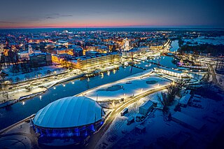
Riga is the capital, the primate, and the largest city of Latvia. Home to 605,273 inhabitants, the city accounts for a third of Latvia's total population. The population of Riga metropolitan area, which stretches beyond the city limits, is estimated at 860,142. The city lies on the Gulf of Riga at the mouth of the Daugava river where it meets the Baltic Sea. Riga's territory covers 307.17 km2 (118.60 sq mi) and lies 1–10 m (3–33 ft) above sea level on a flat and sandy plain.

<span class="mw-page-title-main">Cēsis</span> Town in Latvia

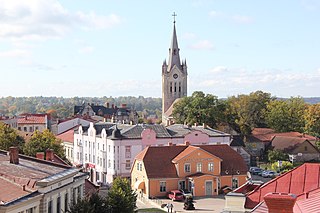
Cēsis, is a town in Latvia located in the northern part of the Central Vidzeme Upland. Cēsis is on the Gauja River valley, and is built on a series of ridges above the river, overlooking the woods below. Cēsis was selected to be one of the candidate cities for the title of the European Capital of Culture 2014.

<span class="mw-page-title-main">Tukums</span> Town in Latvia

Tukums is a town in Latvia and serves as the administrative center of Tukums Municipality. It is located in the eastern part of the historical region of Courland, and with more than 16,000 inhabitants Tukums is the 13th largest settlement in Latvia. It is also an important railroad junction, connecting the town with Riga, Jelgava and Ventspils. It has two railway stations — Tukums I and Tukums II.

<span class="mw-page-title-main">Kuldīga</span> Town in Latvia

Kuldīga is a town in the Courland region of Latvia, in the western part of the country. It is the center of Kuldīga Municipality with a population of approximately 13,500.

<span class="mw-page-title-main">Livonians</span> Ethnic group in the Baltics

The Livonians, or Livs, are a Balto-Finnic people indigenous to northern and northwestern Latvia. Livonians historically spoke Livonian, a Uralic language closely related to Estonian and Finnish. Initially, the last person to have learned and spoken Livonian as a mother tongue, Grizelda Kristiņa, died in 2013, making Livonian an extinct language. In 2020, it was reported that newborn Kuldi Medne had once again become the only living person who speaks Livonian as their first language. As of 2010, there were approximately 30 people who had learned it as a second language.

<span class="mw-page-title-main">Jelgava</span> City in Semigallia, Latvia

Jelgava is a state city in central Latvia. It is located about 41 kilometres southwest of Riga. It is the largest town in the Semigallia region of Latvia. Jelgava was the capital of the united Duchy of Courland and Semigallia (1578–1795) and was the administrative center of the Courland Governorate (1795–1918).

<span class="mw-page-title-main">Bauska</span> Town in Semigallia, Latvia

Bauska is a town in its eponymous municipality, found in the Zemgale region of southern Latvia.

<span class="mw-page-title-main">Semigallia</span> Historic region in Latvia

Semigallia is one of the Historical Latvian Lands located to the south of the Daugava and to the north of the Saule region of Samogitia. The territory is split between Latvia and Lithuania, previously inhabited by the Semigallian Baltic tribe. They are noted for their long resistance (1219–1290) against the German crusaders and Teutonic Knights during the Northern Crusades. Semigallians had close linguistic and cultural ties with Samogitians.

<span class="mw-page-title-main">Limbaži</span> Town in Latvia

Limbaži is a town in the Vidzeme region of northern Latvia, with a population of 6,888. Limbaži is located 90 km northeast of the capital Riga. During the Middle Ages, as part of Livonia, Limbaži was a fortified town with stone walls, second in importance only to Riga.

Arajs <i>Kommando</i> Latvian Nazi collaborating unit that perpetrated the Holocaust

The ArajsKommando, led by SS commander and Nazi collaborator Viktors Arājs, was a unit of Latvian Auxiliary Police subordinated to the German Sicherheitsdienst (SD). It was a notorious killing unit during the Holocaust.

<span class="mw-page-title-main">Koknese</span> Town in Latvia

Koknese is a town in Aizkraukle Municipality in the Vidzeme region of Latvia, on the right bank of the Daugava River. It has a population of nearly 3,000.

<span class="mw-page-title-main">Cesvaine</span> Town in Latvia

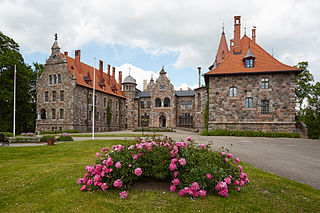
Cesvaine is a town in Madona Municipality, Vidzeme Region, Latvia. It is home to the Cesvaine Palace, built in 1896 near the ruins of previous medieval castles.

<span class="mw-page-title-main">Ikšķile</span> Town in Latvia

Ikšķile is a town in Ogre Municipality, in the Vidzeme region of Latvia. It was the first capital of the Roman Catholic Bishopric of Livonia, known by the German name of Üxküll. Saint Meinhard was the first bishop of Üxküll. In 1197, Berthold of Hanover, a Cistercian abbot of Loccum, was made the second bishop of Üxküll. Those days the town was the center of the upcoming crusading activities in the Livonian area. Bishop Berthold moved the episcopal see to Riga, before being killed by the Livs in battle.

<span class="mw-page-title-main">Livonian Crusade</span> 12th–13th century Baltic Christianisation campaign

The Livonian crusade consists of the various military Christianisation campaigns in medieval Livonia – modern Latvia and Estonia – during the Papal-sanctioned Northern Crusades in the 12th–13th century.

<span class="mw-page-title-main">Kandava</span> Town in Latvia

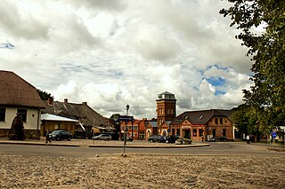
Kandava is a town in Tukums Municipality, in the Courland region of Latvia. It had a population of 3,656 people as of January 2020.

<span class="mw-page-title-main">History of Riga</span> Aspect of Lativian history

The history of Riga, the capital of Latvia, begins as early as the 2nd century with a settlement, the Duna urbs, at a natural harbor not far upriver from the mouth of the Daugava River. Later settled by Livs and Kurs, it was already an established trade center in the early Middle Ages along the Dvina-Dnieper trade route to Byzantium. Christianity had come to Latvia as early as the 9th century, but it was the arrival of the Crusades at the end of the 12th century which brought the Germans and forcible conversion to Christianity; the German hegemony instituted over the Baltics lasted until independence—and is still preserved today in Riga's Jugendstil architecture.

<span class="mw-page-title-main">Salaspils camp</span> Nazi forced labour and concentration camp

Salaspils camp was established at the end of 1941 at a point 18 km (11 mi) southeast of Riga (Latvia), in Salaspils. The Nazi bureaucracy drew distinctions between different types of camps. Officially, it was the Salaspils Police Prison and Re-Education Through Labor Camp. It was also known as camp Kurtenhof after the German name for the city of Salaspils.

<span class="mw-page-title-main">Lielvārde Castle</span> Castle in Latvia

Lielvārde Castle is a castle in Lielvārde, a town in Ogre Municipality in the Vidzeme region of Latvia.The castle was built at the steep bank of Daugava River, overseeing this important medieval waterway, before 1248 by Albert of Buxthoeven, an archbishop of Riga. During the Livonian War, Lielvārde Castle was destroyed by Russian troops in 1579. Its ruins are conserved up to the level of the second floor.

<span class="mw-page-title-main">Ako (ruler)</span> Livonian ruler (died 1206)

Ako was a Livonian ruler and elder of Livonian Daugava from modern-day Salaspils who fought during the Livonian Crusade against the German crusaders and the Livonian Brothers of the Sword in the beginning of the 13th century. In June 4, 1206, Ako died during the Battle of Salaspils, and as a result of the death, his head was brought to Riga for Albert of Riga as a sign of victory against Ako.

References

  1. "SALASPILS - Domes priekšsēdētājs". www.salaspils.lv. Archived from the original on 22 July 2011. Retrieved 12 January 2022.
  2. "Reģionu, novadu, pilsētu un pagastu kopējā un sauszemes platība gada sākumā". Central Statistical Bureau of Latvia. Retrieved 7 January 2025.
  3. "Iedzīvotāju skaits pēc tautības reģionos, pilsētās, novados, pagastos, apkaimēs un blīvi apdzīvotās teritorijās gada sākumā (pēc administratīvi teritoriālās reformas 2021. gadā)". Central Statistical Bureau of Latvia. Retrieved 19 June 2024.
  4. Strods, Heinrihs (2000). "Salaspils koncentrācijas nometne (1944. gada oktobris – 1944. gada septembris)". Yearbook of the Occupation Museum of Latvia (in Latvian). 2000: 87–153. ISSN   1407-6330.
  5. Angrick, Andrej; Klein, Peter (2006). Die "Endlösung" in Riga: Ausbeutung und Vernichtung 1941–1944 (in German). Darmstadt: Wissenschaftliche Buchgesellschaft. p. 269. ISBN   3-534-19149-8. OCLC   69983159.
  6. Kangeris, Kārlis; Neiburgs, Uldis; Vīksne, Rudīte (2016). Aiz šiem vārtiem vaid zeme. Salaspils nometne 1941 – 1944 (in Latvian). Rīga: Lauku Avīze. p. 430. ISBN   9789934151286.
  7. "Arhīvs / Diena". www.diena.lv. Retrieved 23 April 2018.
  8. (in Russian)Latvia Under The Yoke Of Nazism: Collected Archive Documents, Moscow: Europe Publisher, 2006, p.83, available online
  9. "Question about Salaspils • Axis History Forum". Axis History Forum. Retrieved 23 April 2018.
  10. "Sadraudzības pilsētas". salaspils.lv (in Latvian). Salaspils. Archived from the original on 2015-06-25. Retrieved 2019-08-31.