
The River Camel is a river in Cornwall, England. It rises on the edge of Bodmin Moor and with its tributaries its catchment area covers much of North Cornwall. The river flows into the eastern Celtic Sea between Stepper Point and Pentire Point having covered about 30 miles, making it the second longest river wholly in Cornwall. The river is tidal upstream to Egloshayle and is popular for sailing, birdwatching and fishing. The name Camel comes from the Cornish language for 'the crooked one', a reference to its winding course. Historically the river was divided into three named stretches. Heyl was the name for the estuary up to Egloshayle, the River Allen was the stretch between Egloshayle and Trecarne, whilst the Camel was reserved for the stretch of river between its source and Trecarne.

Saltburn-by-the-Sea, commonly referred to as Saltburn, is a seaside town in Redcar and Cleveland, North Yorkshire, England, around 12 miles (19 km) south-east of Hartlepool and just under 5 miles (8.0 km) south-east of Redcar.
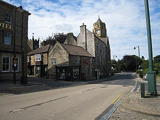
Loftus is a market town and civil parish in the Redcar and Cleveland borough of North Yorkshire, England. The town is located north of the North York Moors and sits between Whitby and Skelton-in-Cleveland.
Brotton is a village in the civil parish of Skelton and Brotton, in the Redcar and Cleveland district, in the ceremonial county of North Yorkshire, England It is situated approximately 2.5 miles (4 km) south-east of Saltburn-by-the-Sea, 9 miles from Redcar, 12 miles (19 km) east of Middlesbrough and 14 miles (23 km) north-west of Whitby.

Boulby is a hamlet in the Loftus parish, located within the North York Moors National Park. It is in the borough of Redcar and Cleveland, North Yorkshire, England. The hamlet is located off the A174, near Easington and 1-mile (1.6 km) west of Staithes.

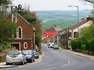
Easington is a village in the civil parish of Loftus, in the Redcar and Cleveland district, in the ceremonial county of North Yorkshire, England and is part of the North York Moors National Park. The village is situated on the A174 road, 1 mile (1.6 km) east of Loftus, 8 miles (13 km) east of Guisborough, and 10 miles (16 km) north-west of Whitby. At the 2011 census, the village had a population of 923.
Charltons is a village in the borough of Redcar and Cleveland and the ceremonial county of North Yorkshire, England.

Upleatham is a village in the civil parish of Guisborough, in the unitary authority area of Redcar and Cleveland and the ceremonial county of North Yorkshire, England. The village was mentioned in the Domesday Book and the name derives from Old English and Old Norse as Upper Slope, in that it was further up the hill than Kirkleatham.
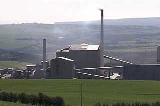
Boulby Mine is a 200-hectare (490-acre) site located just south-east of the village of Boulby, on the north-east coast of the North York Moors in Loftus, North Yorkshire England. It is run by Cleveland Potash Limited, which is now a subsidiary of Israel Chemicals Ltd. (ICL).

Lockwood is a civil parish in the unitary authority of Redcar and Cleveland with ceremonial association with North Yorkshire, England. The population of Lockwood ward in the Redcar and Cleveland Unitary authority taken at the 2011 census was 2,022.
The Whitby, Redcar and Middlesbrough Union Railway (WRMU), a.k.a. the Whitby–Loftus Line, was a railway line in North Yorkshire, England, built between 1871 and 1886, running from Loftus on the Yorkshire coast to the Esk at Whitby, and connecting Middlesbrough to Whitby along the coast.
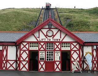
The Saltburn Cliff Lift is a funicular railway in Saltburn-by-the-Sea, Redcar and Cleveland in the ceremonial county of North Yorkshire, England. It provides access to Saltburn Pier and the seafront from the town. The cliff lift is the oldest operating water-balance cliff funicular in the United Kingdom.

The River Burn is a river that flows wholly within North Yorkshire, England. The river starts as several small streams on Masham Moor and drains Colsterdale flowing eastwards before emptying into the River Ure just south of Masham. Conservation work on removing a weir, and introducing fish to the river in 2016, has meant that salmon have been recorded spawning in the river for the first time in over 100 years.

Scaling Dam Reservoir is a freshwater man-made lake on the edge of the A171 road in North Yorkshire, England. The reservoir is near to the hamlet of Scaling Dam from where it derives its name, and was built in 1958.

The Yorkshire coast fishery has long been part of the Yorkshire economy for centuries. The 114-mile (183 km) Yorkshire Coast, from the River Tees to the Humber estuary, has many ports both small and large where the fishing trade thrives. The historic ports at Hull and Whitby are important locations for the landing and processing of fish and shellfish. Scarborough and Bridlington are also sites of commercial fishing.
Ironstone mining in Cleveland and North Yorkshire occurred on a sizeable scale from the 1830s to the 1960s in present day eastern parts of North Yorkshire but has been recorded as far back as Roman times in mostly a small-scale and intended for local use. This Cleveland is not to be confused with a smaller area covered by the county of Cleveland from 1974-96.

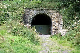
Kilton Viaduct was a railway viaduct that straddled Kilton Beck, near to Loftus, in North Yorkshire, England. The viaduct was opened to traffic in 1867, however in 1911, with the viaduct suffering subsidence from the nearby ironstone mining, the whole structure was encased in waste material from the mines creating an embankment which re-opened fully to traffic in 1913. The railway closed in 1963, but then in 1974, it re-opened as part of the freight line to Boulby Mine carrying potash traffic.

Hutton Village is a settlement in the Hutton Lowcross area of Guisborough in North Yorkshire, England. Whilst the area itself is mentioned in the Domesday Book, the village was built largely due to the development of the ironstone industry in the Cleveland Hills. The name Hutton Lowcross referred to the township in the area, whereas the settlement is now known as Hutton Village. The village is set in a narrow dale that carries Hutton Beck northwards towards Guisborough.

Skelton Beck is a small river in North Yorkshire, England. The beck only runs for 23 kilometres (14 mi) and feeds directly into the North Sea on the south side of Saltburn beach. The beck is noted for occasionally being polluted with wastewater from the abandoned ironstone workings in its headwaters.
