Briarcroft Pasture

Last updated

Briarcroft Pasture
Durham UK relief location map.jpg
Red pog.svg
Location Stockton-on-Tees, County Durham, England
Coordinates 54°34′4″N1°23′23″W / 54.56778°N 1.38972°W / 54.56778; -1.38972
Area1.8 ha (4.4 acres)
Established2004
Governing bodyNatural England
Website Map of site

Briarcroft Pasture (grid reference NZ394193 ) is a 1.76 hectare biological Site of Special Scientific Interest in County Durham, England notified in 2004.

Contents

Reason for notification

SSSIs are designated by Natural England, formally English Nature, which uses the 1974–1996 county system. This means there is no grouping of SSSIs by Stockton-on-Tees unitary authority, or County Durham which is the relevant ceremonial county . As such Briarcroft Pasture is one of 18 SSSIs in the Cleveland area of search. [1]

Briarcroft Pasture is nationally important for its species-rich grassland which is unimproved by fertilisers. This type of grassland – once common in the Tees lowland – is becoming increasingly rare, with associated species also becoming rare. Briarcroft Pasture is one of only two remaining examples of this habitat in the Tees lowland area. The other example is Whitton Bridge Pasture an SSSI approximately 3 km to the north which was designated at the same time but is significantly larger. [2] [3]

Under the British National Vegetation Classification (NVC), Briarcroft Pasture is considered as mesotrophic grassland because it represents a well-drained and permanent pasture. In particular it is considered the MG5 community due to the species present. MG5 is widespread in many lowland areas in England, Wales and Scotland as well as the Midlands and Yorkshire. Briarcroft Pasture is predominantly subcommunity MG5c (Danthonia decumbens); however, this forms a mosaic with community MG9, which is associated with poorly drained permanent pastures. [4] [5]

Site description

Abiotic

Red Fescue is one of the dominant species in subcommunity MG5c and is found at Briarcroft Pasture. Festuca.rubra.2.jpg
Red Fescue is one of the dominant species in subcommunity MG5c and is found at Briarcroft Pasture.

Briarcrift Pasture, located west of Stockton-on-Tees and close to Whinney Hill, County Durham, is a small site 1.8 hectares (4.4 acres). Topographically the site is level and has an altitude of approximately 50 m and is adjacent to a small stream. [5] [6] The underlying geology of Whitton Bridge Pasture is responsible for shaping the species-rich community found on the surface. Glacial tills and sands are the prominent geological features resulting in a relatively base-poor soil, characteristic of glacial drift geology. The soils of MG5c (Danthonia decumbens) subcommunity are typically acidic. [5]

Located in North East England, Briarcroft Pasture experience a climate that differs from the UK average. [A] The North East receives on average 370 mm less rainfall than the UK over a year. Similarly the North East has roughly 129 days each year with more than 1 mm of rainfall, this is over 25 days less than UK average. Temperature is similar for both the North East and the UK, although the North East does have fewer days with air frost and more hours of sunshine per year. [7] [8]

Biotic

The majority of the site is made up of species-rich grassland (subcommunity MG5c), which comprises three dominant species of grass and several other grass species at lower abundances. The dominant species are Red Fescue (Festuca rubra), Common Bent (Agrostis capillaris) and Yorkshire Fog (Holcus lanatus). The less abundant species of grass include, Crested Dog’s-tail (Cynosurus cristatus), Heath-grass (Danthonia decumbens) and Cocksfoot (Dactylis glomerata). The subcommunity also has many broad-leaved herbs including Common Knapweed (Centaurea nigra), Tormentil (Potentilla erecta), Devils-bit scabious (Succisa pratensis) and Betony (Stachys officinalis). [5]

A second community, MG9, forms a mosaic with the species rich grassland of MG5. This second community is associated with Holcus lanatus and Deschampsia caespitosa. Other prominent plants are herbs, including many species with a local distribution among them; Saw-wort (Serratula tinctoria) and dyer’s greenweed (Genista tinctoria). Meadow Barley (Hordeum secalinum) is also present. [5]

Notes

It is therefore likely that the differences described in the article are an underestimate of how Whitton Bridge Pasture differs to the national climate.

Related Research Articles

<i>Holcus lanatus</i> Species of plant

Holcus lanatus is a perennial flowering plant in the grass family Poaceae. The specific epithet lanatus is Latin for 'woolly' which describes the plant's hairy texture. Common names include Yorkshire fog, tufted grass, and meadow soft grass. In North America, where it is an invasive species, names include velvet grass and common velvet grass.

The mesotrophic grassland communities in the British National Vegetation Classification system were described in Volume 3 of British Plant Communities, first published in 1992, along with the calcicolous grassland communities and the calcifugous grasslands and montane communities.

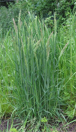
British NVC community MG12 (Festuca arundinacea grassland) is one of the mesotrophic grassland communities in the British National Vegetation Classification system. It is one of three types of mesotrophic grassland classified as grass-dominated inundation communities.

<i>Deschampsia cespitosa</i> Species of flowering plant

Deschampsia cespitosa, commonly known as tufted hairgrass or tussock grass, is a perennial tufted plant in the grass family Poaceae. Distribution of this species is widespread including the eastern and western coasts of North America, parts of South America, Eurasia and Australia.

<span class="mw-page-title-main">Plaster's Green Meadows</span>

Plaster's Green Meadows is a 4.3 hectare biological Site of Special Scientific Interest near the village of Nempnett Thrubwell, Bath and North East Somerset, notified in 1989.

Whitton Bridge Pasture is a Site of Special Scientific Interest (SSSI) in the unitary authority of Stockton-on-Tees, England. At 3.18 hectares (7.9 acres) it lies to the south of Whitton village and north west of Stockton-on-Tees. SSSIs are chosen by Natural England, and Whitton Bridge Pasture was designated in 2004 because of its biological interest. It is one of 18 SSSIs in the Cleveland area of search.

British NVC community MG10 is one of the mesotrophic grassland communities in the British National Vegetation Classification system. It is one of three communities associated with poorly drained permanent pastures.

NVC community CG2 is one of the calcicolous grassland communities in the British National Vegetation Classification system. It is one of three short-sward communities associated with heavy grazing, within the lowland calcicolous grassland group, and is regarded as "typical" chalk grassland.

British NVC community MG9 is one of the mesotrophic grassland communities in the British National Vegetation Classification system. It is one of three communities associated with poorly drained permanent pastures.

British NVC community MG8 is one of the mesotrophic grassland communities in the British National Vegetation Classification system. It is one of three communities associated with poorly drained permanent pastures.

British NVC community MG5 is one of the mesotrophic grassland communities in the British National Vegetation Classification system. It is one of four such communities associated with well-drained permanent pastures and meadows.

British NVC community MG6 is one of the mesotrophic grassland communities in the British National Vegetation Classification system. It is one of four such communities associated with well-drained permanent pastures and meadows.

British NVC community MG3 is one of the mesotrophic grassland communities in the British National Vegetation Classification system. It is one of four such communities associated with well-drained permanent pastures and meadows.

British NVC community MG4 is one of the mesotrophic grassland communities in the British National Vegetation Classification system. It is one of four such communities associated with well-drained permanent pastures and meadows.

NVC community CG4 is one of the calcicolous grassland communities in the British National Vegetation Classification system. It is one of four communities of rank, tussocky grassland associated with low levels of grazing, within the lowland calcicolous grassland group.

Monkspath Meadow is a 1.2 ha ancient hay-meadow and a biological site of Special Scientific Interest in the West Midlands. The site was notified in 1986 under the Wildlife and Countryside Act 1981. It is on the south-eastern edge of Monkspath. The site has recently been targeted for development for houses but these plans have been met with uproar from locals in Monkspath and nearby villages, such as Cheswick Green and Hockley Heath, as it would destroy such a special natural site.

Middleton Quarry is a Site of Special Scientific Interest in the Teesdale district of west County Durham, England. It is a disused quarry, from which Whin Sill stone was formerly excavated. It lies just south of the River Tees, opposite the village of Middleton-in-Teesdale on the river's northern bank.

Allolee to Walltown is the name given to a Site of Special Scientific Interest (SSSI) in Northumberland, England. The site, which follows the path of a section of Hadrian's Wall, is notable for an unusually wide range of grassland types growing on thin soil above the Whin Sill, a rock formation peculiar to the Northern Pennines.

<span class="mw-page-title-main">Arcot Hall Grasslands and Ponds</span>

Arcot Hall Grasslands and Ponds is the name given to a Site of Special Scientific Interest (SSSI) near Cramlington in Northumberland, England, notable as the largest lowland species-rich grassland in North East England. The site is composed of grassland, heath, ponds, and associated damp habitats now rare in Northumberland.

<span class="mw-page-title-main">Inkpen Crocus Field</span>

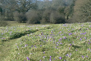
Inkpen Crocus Fields is a 3.1-hectare (7.7-acre) biological Site of Special Scientific Interest near Inkpen in Berkshire. It is managed by the Berkshire, Buckinghamshire and Oxfordshire Wildlife Trust.

References

  1. "SSSIs in Cleveland area of search". English Nature. Retrieved 31 January 2007.
  2. "Whitton Bridge Pasture citation sheet" (PDF). English Nature. Retrieved 2 February 2006.
  3. "Stockton-on-Tees Borough annual monitoring report 2004/2005" (PDF). Stockton-on-Tees Borough council. Retrieved 3 February 2007.[ dead link ]
  4. John S. Rodwell, ed. (1998). British Plant Communities Volume 3: Grasslands and montane communities. Cambridge University Press. p. 63. ISBN   0-521-62719-2.
  5. 1 2 3 4 5 "Briarcroft Pasture citation sheet" (PDF). English Nature. Retrieved 31 January 2007.
  6. "Site map". Nature on the Map. Retrieved 17 August 2007.
  7. "UK average climate". Met Office. Archived from the original on 5 July 2009. Retrieved 24 February 2007.
  8. "East and North East England average climate". Met Office. Archived from the original on 9 January 2007. Retrieved 24 February 2007.