Lamongan Regency is a regency (kabupaten) of East Java, Indonesia. It has a total land area of approximately 1,812.8 km2 (699.9 sq mi) or + 3.78% of the area of East Java Province. With a length of 47 km along the coastline, the sea area of Lamongan Regency is about 902.4 km2, if calculated to a distance of 12 miles across the ocean surface. At the 2010 Census it had a population of 1,179,059; the 2020 Census produced a total of about 1,344,000. The administrative centre is the town of Lamongan.

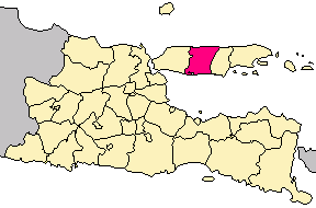
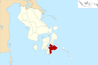
Pamekasan Regency is a regency (kabupaten) of the province of East Java, Indonesia. It is located on Madura Island approximately 120 km east of Surabaya, the provincial capital.
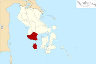
Sampang Regency is a regency of East Java province, Indonesia. It is situated on Madura Island, bordering on Pamekasan Regency to the east, the Java Sea to the north, Bangkalan Regency to the west and Madura Strait to the south. It covers an area of 1,233.3 km2, and had a population at the 2010 census of 877,772 and at the 2020 Census of 969,694. The administrative centre is the port of Sampang, on the south coast of Madura.

Bangli is a regency (kabupaten) of Bali, Indonesia. It covers an area of 520.81 km2 and had a population of 215,353 at the 2010 Census and 258,721 at the 2020 Census. Its regency seat is the town of Bangli.

Barito Kuala Regency is one of the regencies (kabupaten) in the Indonesian province of South Kalimantan. The area is 2,996.46 km2, and the population at the 2010 Census was 276,147; the latest official estimate is 313,595. The capital is Marabahan. The Motto of the Regency is "Selidah".

Sorong Regency is a regency of West Papua Province of Indonesia. It covers an area of 13,075.28 km2, and had a population of 70,619 at the 2010 Census, and 118,679 at the 2020 Census. Its administrative centre is the town of Aimas. Sorong Regency surrounds Sorong City (Kota), which is independent of the Regency; Sorong City has an airport, Sorong Airport, which also serves the Regency.

Supiori Regency is a regency in the Indonesian province of Papua. The Regency has an area of 634.24 km2 including the Aruri Islands group to the south, and had a population of 15,874 at the 2010 Census and 22,547 at the 2020 Census. Until 8 January 2004, this area was part of the Biak Numfor Regency, from which it was split off in accordance with the Law dated 18 December 2003.
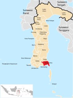
Bulukumba Regency is a regency in the southeast corner of South Sulawesi Province, Indonesia. It covers an area of 1,154.58 km2, and had a population of 394,757 at the 2010 Census and 437,607 at the 2020 Census. The town of Bulukumba is its capital.
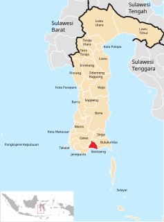
Bantaeng Regency is a regency of South Sulawesi Province in Indonesia. It covers an area of 395.83 km2 and had a population of 176,984 at the 2010 Census, rising to 196,716 at the 2020 Census. The administrative centre is the town of Bantaeng, which lies on the south coast of the southern peninsula of Sulawesi island.

The Pangkajene and Islands Regency is a regency of South Sulawesi Province of Indonesia. The regency lies primarily on the mainland of Sulawesi's southern peninsula, but also includes the Spermonde Islands off the west coast of that peninsula, as well as other small islands further west and southwest. The principal town lies at Pangkajene on Sulawesi, but there are a series of further towns like Lejang, Labakkang, Bontobonto and Segeri proceeding northwards from Pangkajene along the Trans-Sulawesi Highway. The total land area is 1,112.29 km2, and the population was 305,737 at the 2010 Census and 345,775 at the 2020 Census.
Bombana Regency is a regency of Southeast Sulawesi Province of Indonesia. It consists of part of the southeast peninsula of Sulawesi, together with most of the substantial offshore island of Kabaena to the south. It covers an area of 3,316.16 km2, and had a population on 139,235 at the 2010 Census and 150,706 at the 2020 Census. The administrative centre lies at the town of Rumbia.
Buton Regency is a regency of Indonesia's Southeast Sulawesi Province, lying entirely on Buton Island. Until 2014 it had an area of 2,681.22 km2, and a population estimated at 276,944. However, in 2014 it was divided into three regencies, with two new regencies being cut out of it; the residual area now is 1,648.04 km2, and the districts in that area contained a population of 94,388 at the 2010 Census while the 2020 Census produced a total of 115,207.

Kolaka Regency is a regency of Southeast Sulawesi Province, Indonesia. It covers an area of 2,958.69 km2 and had a population of 208,817 at the 2010 Census, rising to 237,587 at the 2020 Census. The principal town lies at Kolaka.
North Buton Regency is a regency of Indonesia's Southeast Sulawesi Province, which was separated from Buton Regency in accordance with Indonesia's Law Number 14 of 2007. The area of the regency, which covers the north part of Buton Island, is 1,923.03 km2. Its population was 54,736 at the 2010 Census and 66,653 at the 2020 Census. The principal town lies at Buranga.

North Kolaka Regency is a regency in the northwest part of Southeast Sulawesi province of Indonesia. It covers an area of 2,924.46 km2, and had a population of 121,476 at the 2010 Census, and 137,700 at the 2020 Census. The principal town lies at Lasusua.

South Konawe Regency is a regency of Southeast Sulawesi Province, Indonesia. It covers an area of 4,200.89 km2 and had a population of 264,587 at the 2010 Census and of 308,524 at the 2020 Census. The administrative centre is in the town of Andoolo.
East Bolaang Mongondow Regency is a regency of North Sulawesi Province of Indonesia. It covers an area of 910.18 sq km and had a population of 63,654 at the 2010 Census, rising to 87,241 at the 2020 Census. The principal town lies at Tutuyan.

South Minahasa Regency is a regency in North Sulawesi, Indonesia. Its capital is Amurang. It covers an area of 1,456.46 km2, and had a population of 195,553 at the 2010 Census; this had risen to 236,463 at the 2020 Census. It was originally part of the Minahasa Regency until it was established as a separate regency on 25 February 2003. In turn, a Southeast Minahasa Regency was established as a separate regency from part of the South Minahasa Regency on 2 January 2007.

Southeast Minahasa Regency is a regency in North Sulawesi, Indonesia. Its capital is Ratahan. It covers an area of 710.83 km2, and had a population of 100,443 at the 2010 Census; this had risen to 116,323 at the 2020 Census. It was established as a separate regency from part of the South Minahasa Regency on 2 January 2007. Its administrative centre is at Ratahan.

South Buru Regency is a regency of Maluku, Indonesia. It is located on the island of Buru, of which it comprises the southern half. The Regency covers an area of 5,060 km2, and it had a population of 53,671 at the 2010 Census, rising to 75,410 at the 2020 Census. The principal town lies at Namrole.