Istria is the largest peninsula within the Adriatic Sea. Located at the top of the Adriatic between the Gulf of Trieste and the Kvarner Gulf, the peninsula is shared by three countries: Croatia, Slovenia, and Italy, 90% of its area being part of Croatia. Most of Croatian Istria is part of Istria County.
The Free Territory of Trieste was an independent territory in Southern Europe between Northern Italy and Yugoslavia, facing the north part of the Adriatic Sea, under direct responsibility of the United Nations Security Council in the aftermath of World War II. For a period of seven years, it acted as a free city.

Koper is the fifth-largest city in Slovenia. Located in the Istrian region in the southwestern part of the country, Koper is the main urban center of the Slovene coast. Port of Koper is the country's only container port and a major contributor to the economy of the Municipality of Koper. The city is a destination for a number of Mediterranean cruising lines.
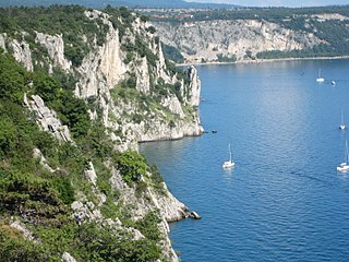
The Karst Plateau or the Karst region, also locally called Karst, is a karst plateau region extending across the border of southwestern Slovenia and northeastern Italy.

The province of Trieste is a province in the autonomous Friuli-Venezia Giulia region of Italy. Its capital was the city of Trieste. It had an area of 212 square kilometres (82 sq mi) and it had a total population of 234,668. It had a coastal length of 48.1 kilometres (29.9 mi). Abolished in 2017, it was reestablished in 2019 as the regional decentralization entity of Trieste, and was reactivated on 1 July 2020.

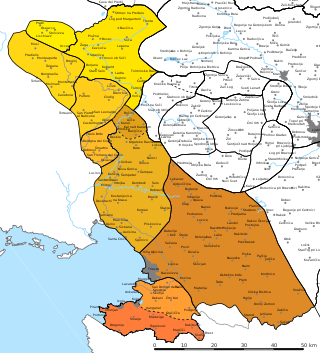
The Julian March, also called Julian Venetia, is an area of southern Central Europe which is currently divided among Croatia, Italy, and Slovenia. The term was coined in 1863 by the Italian linguist Graziadio Isaia Ascoli, a native of the area, to demonstrate that the Austrian Littoral, Veneto, Friuli, and Trentino shared a common Italian linguistic identity. Ascoli emphasized the Augustan partition of Roman Italy at the beginning of the Empire, when Venetia et Histria was Regio X.

The Municipality of Hrpelje-Kozina is a municipality in the Littoral region of Slovenia. Its seat is the village of Hrpelje.

The Morgan Line was the line of demarcation set up after World War II in the region known as Julian March which prior to the war belonged to the Kingdom of Italy. The Morgan Line was the border between two military administrations in the region: the Yugoslav on the east, and that of the Allied Military Government on the west. After 15 September 1947, the Allied Military Government was composed of both the British Element Trieste Forces (BETFOR) troops from the United Kingdom and the Trieste United States Troops (TRUST) from the United States.

Muggia is an Italian town and comune (municipality) in south-eastern regional decentralization entity of Trieste, in the region of Friuli-Venezia Giulia on the border with Slovenia. Lying on the eastern flank of the Gulf of Trieste in the northern Adriatic Sea, Muggia is the only Italian port town in Istria. The town's architecture is marked by its Venetian and Austrian history, and its harbour hosts a modern 500-berth marina for yachts.

Osp is a village in the City Municipality of Koper in the Littoral region of Slovenia.
The Italian language is an officially recognized minority language in Slovenia, along with Hungarian. Around 3,700 Slovenian citizens speak Italian as their mother tongue, mostly Istrian Italians. Their numbers drastically decreased following the Istrian–Dalmatian exodus (1943–1960). Italian has a strong presence in Slovenia, both historical and current. An estimated 15% of Slovenians speak Italian as a second language, which is one of the highest percentages in the European Union.

The Slovene lands or Slovenian lands is the historical denomination for the territories in Central and Southern Europe where people primarily spoke Slovene. The Slovene lands were part of the Illyrian provinces, the Austrian Empire and Austria-Hungary. They encompassed Carniola, southern part of Carinthia, southern part of Styria, Istria, Gorizia and Gradisca, Trieste, and Prekmurje. Their territory more or less corresponds to modern Slovenia and the adjacent territories in Italy, Austria, Hungary, and Croatia, where autochthonous Slovene minorities live. The areas surrounding present-day Slovenia were never homogeneously ethnically Slovene.

Spodnje Škofije is a settlement in the City Municipality of Koper in the Littoral region of Slovenia. A major border crossing on the Highway 5 into Italy was located here, with the Italian side known as Rabuiese.

Plavje is a village in the City Municipality of Koper in the Littoral region of Slovenia. It is located on the northernmost edge of the Istrian peninsula, on the border with Italy, on a small hill overlooking the Gulf of Trieste.

Istrian Italians are an ethnic group from the Adriatic region of Istria in modern northwestern Croatia and southwestern Slovenia. Istrian Italians descend from the original Latinized population of Roman Histria, from the Venetian-speaking settlers who colonized the region during the time of the Republic of Venice, and from the local Croatian people who culturally assimilated.

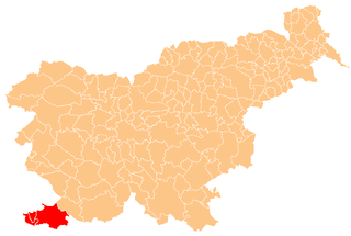
Slovene Istria is a region in southwest Slovenia. It comprises the northern part of the Istrian peninsula, and is part of the wider geographical-historical region known as the Slovene Littoral. Its largest urban center is Koper. Other large settlements are Izola, Piran, and Portorož. The entire region has around 120 settlements. In its coastal area, both Slovene and Italian are official languages.

The Slavic-Italian Anti-Fascist Union was a political movement in the Free Territory of Trieste. It was the most important mass organization of the Communist Party of the Free Territory of Trieste (PCTLT/KPSTO). UAIS/SIAU had around 70,000 members.
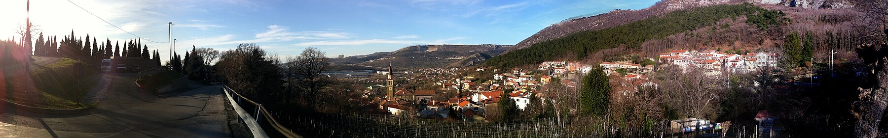
The Rižana subdialect is a Slovene subdialect of the Istrian dialect in the Littoral dialect group. It is spoken in Italy in most of the municipalities of San Dorligo della Valle and Muggia south of Trieste, as well as in some southern suburbs of Trieste ; in Slovenia, it is spoken in the northern part of Slovene Istria, in the Rižana Valley east and north of Koper, including the settlements of Bertoki, Dekani, Osp, Črni Kal, Presnica, Podgorje, and Zazid.
The Istrian dialect is a Slovene dialect spoken in Slovene Istria, as well as some settlements in Italy and Croatia. The dialect borders the Inner Carniolan dialect to the north and northeast, the Southern Chakavian and Buzet dialects to the south, the Southwestern Istrian dialect to the southeast, and the Čičarija dialect to the east. The dialect belongs to the Littoral dialect group, and it evolved from Lower Carniolan dialect base.
Slovene minority in Italy, also known as Slovenes in Italy is the name given to Italian citizens who belong to the autochthonous Slovene ethnic and linguistic minority living in the Italian autonomous region of Friuli-Venezia Giulia. The vast majority of members of the Slovene ethnic minority live in the Provinces of Trieste, Gorizia, and Udine. Estimates of their number vary significantly; the official figures show 52,194 Slovenian speakers in Friuli-Venezia Giulia, as per the 1971 census, but Slovenian estimates speak of 83,000 to 100,000 people.