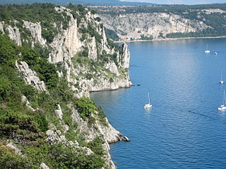
The Karst Plateau or the Karst region, also locally called Karst, is a karst plateau region extending across the border of southwestern Slovenia and northeastern Italy.

The province of Trieste is a province in the autonomous Friuli-Venezia Giulia region of Italy. Its capital was the city of Trieste. It had an area of 212 square kilometres (82 sq mi) and it had a total population of 234,668. It had a coastal length of 48.1 kilometres (29.9 mi). Abolished in 2017, it was reestablished in 2019 as the regional decentralization entity of Trieste, and was reactivated on 1 July 2020.
Drenchia is a comune (municipality) in the Regional decentralization entity of Udine in the Italian region of Friuli-Venezia Giulia, located about 60 kilometres (37 mi) north of Trieste and about 35 kilometres (22 mi) northeast of Udine, on the border with Slovenia. Drenchia is located on the western slopes of the Kolovrat Range, dividing Italy from Slovenia, and borders the following municipalities: Grimacco, Kanal ob Soči (Slovenia), Kobarid (Slovenia), and Tolmin (Slovenia).
Grimacco is a comune (municipality) in the Regional decentralization entity of Udine in the Italian region Friuli-Venezia Giulia, located about 60 kilometres (37 mi) northwest of Trieste and about 25 kilometres (16 mi) northeast of Udine, on the border with Slovenia, and borders the following municipalities: Drenchia, Kanal ob Soči (Slovenia), Kobarid (Slovenia), San Leonardo, Savogna, Stregna.

Lusevera is a comune (municipality) in the Regional decentralization entity of Udine in the Italian region of Friuli-Venezia Giulia, located about 80 kilometres (50 mi) northwest of Trieste and about 20 kilometres (12 mi) north of Udine, on the border with Slovenia, and borders the following municipalities: Gemona del Friuli, Kobarid (Slovenia), Montenars, Nimis, Resia, Taipana, Tarcento, and Venzone.

Prepotto is a comune (municipality) in the Regional decentralization entity of Udine in the Italian region of Friuli-Venezia Giulia, located about 50 kilometres (31 mi) northwest of Trieste and about 20 kilometres (12 mi) east of Udine, on the border with Slovenia. As of 31 December 2004, it had a population of 894 and an area of 33.2 square kilometres (12.8 sq mi).
Resia is a comune (municipality) in the Regional decentralization entity of Udine, in the Friuli-Venezia Giulia region of northeast Italy, bordering on the municipalities of Chiusaforte, Lusevera, Resiutta, and Venzone, and also on two of the Slovenian municipalities. Its residents speak an archaic dialect known as Resian, which is – according to most linguists – a transitional dialect between the Carinthian and Littoral dialects of Slovene. Although they maintain their own traditional system of family names, which are of Slavic origin, the people of Resia have either Italian or Italianized surnames, similarly to some areas in Venetian Slovenia.
Savogna is a comune (municipality) in the Regional decentralization entity of Udine in the Italian region of Friuli-Venezia Giulia, located about 60 kilometres (37 mi) northwest of Trieste and about 25 kilometres (16 mi) northeast of Udine, on the border with Slovenia.

Stregna is a comune (municipality) in the Regional decentralization entity of Udine in the Italian region of Friuli-Venezia Giulia, located about 60 kilometres (37 mi) northwest of Trieste and about 30 kilometres (19 mi) northeast of Udine, on the border with Slovenia, and borders the following municipalities: Grimacco, Kanal ob Soči (Slovenia), San Leonardo, and Prepotto. The name of the settlement comes from the Slovene word srednje, meaning "the middle one".

Taipana is a comune (municipality) in the Regional decentralization entity of Udine in the Italian region of Friuli-Venezia Giulia, located about 80 kilometres (50 mi) northwest of Trieste and about 20 kilometres (12 mi) northeast of Udine, on the border with Slovenia. As of 31 December 2004, it had a population of 737 and an area of 65.6 square kilometres (25.3 sq mi). According to the census 1971 74,4% of the population are Slovenes.
Torreano is a comune (municipality) in the Regional decentralization entity of Udine in the Italian region of Friuli-Venezia Giulia, located about 60 kilometres (37 mi) northwest of Trieste and about 15 kilometres (9 mi) northeast of Udine, on the border with Slovenia. As of 31 December 2004, it had a population of 2,301 and an area of 34.9 square kilometres (13.5 sq mi). According to the census 1971 24,5% of the population are Slovenes.

Cormons or Cormòns is a comune (municipality) in the Regional decentralization entity of Gorizia in the Italian region of Friuli-Venezia Giulia, located about 45 kilometres (28 mi) northwest of Trieste and about 12 kilometres (7 mi) west of Gorizia, on the border with Slovenia.

Doberdò del Lago is a comune (municipality) in the Regional decentralization entity of Gorizia in the Italian region of Friuli-Venezia Giulia, located about 30 kilometres (19 mi) northwest of Trieste and about 11 kilometres (7 mi) southwest of Gorizia, and borders the following municipalities: Duino-Aurisina, Fogliano Redipuglia, Komen (Slovenia), Miren-Kostanjevica (Slovenia), Monfalcone, Ronchi dei Legionari, Sagrado and Savogna d'Isonzo. It is located in the westernmost part of the Karst Plateau.
Dolegna del Collio is a comune (municipality) in the Regional decentralization entity of Gorizia in the Italian region of Friuli-Venezia Giulia, located about 50 kilometres (31 mi) northwest of Trieste and about 15 kilometres (9 mi) northwest of Gorizia, on the border with Slovenia. As of 31 December 2004, it had a population of 419 and an area of 12.5 square kilometres (4.8 sq mi).
San Floriano del Collio is a comune (municipality) in the Regional decentralization entity of Gorizia in the Italian region of Friuli-Venezia Giulia, located about 40 kilometres (25 mi) northwest of Trieste and about 6 kilometres (4 mi) northwest of Gorizia, on the border with Slovenia, and borders the following municipalities: Brda (Slovenia), Capriva del Friuli, Cormons, Gorizia, Mossa.

Savogna d'Isonzo is a comune (municipality) in the Regional decentralization entity of Gorizia in the Italian region of Friuli-Venezia Giulia, located about 35 kilometres (22 mi) northwest of Trieste and about 3 kilometres (1.9 mi) southwest of Gorizia, on the border with Slovenia. The name of the village comes from the Slovene word sovodnje, which means "confluence". Near Savogna, in fact, the Vipava river flows into the Isonzo at the conjunction of the Karst Plateau and the Vipava Valley.

Duino-Aurisina is a comune (municipality) in the Regional decentralization entity of Trieste in the Italian region of Friuli-Venezia Giulia. Lying near the border with Slovenia, it has a substantial Slovene minority. It is named by the two major settlements, Duino and Aurisina.

Monrupino is a comune (municipality) in the Regional decentralization entity of Trieste in the Italian region of Friuli-Venezia Giulia, located about 9 kilometres (5.6 mi) north of Trieste, on the border with Slovenia. As of 31 December 2004, it had a population of 848 and an area of 12.7 square kilometres (4.9 sq mi). According to the 1971 census, 77.3% of the population are Slovenes.

San Dorligo della Valle is a comune (municipality) in the Regional decentralization entity of Trieste in the Italian region of Friuli-Venezia Giulia, located about 4 kilometres southeast of Trieste, on the border with Slovenia. As of 31 December 2004, it had a population of 6,019 and an area of 24.5 square kilometres (9.5 sq mi).
Gabrovizza (Italian) or Gabrovec (Slovene) is a village in the Comune of Sgonico/Zgonik in the Italian region Friuli-Venezia Giulia, located about 10 kilometres (7 mi) northwest of Trieste, on the border with Slovenia.


