Juan Bautista de Anza Bezerra Nieto was an expeditionary leader, military officer, and politician primarily in California and New Mexico under the Spanish Empire. He is credited as one of the founding fathers of Spanish California and served as an official within New Spain as Governor of the province of New Mexico.

The Guadalupe River mainstem is an urban, northward flowing 14 miles (23 km) river in California whose much longer headwater creeks originate in the Santa Cruz Mountains. The river mainstem now begins on the Santa Clara Valley floor when Los Alamitos Creek exits Lake Almaden and joins Guadalupe Creek just downstream of Coleman Road in San Jose, California. From here it flows north through San Jose, where it receives Los Gatos Creek, a major tributary. The Guadalupe River serves as the eastern boundary of the City of Santa Clara and the western boundary of Alviso, and after coursing through San José, it empties into south San Francisco Bay at the Alviso Slough.

The Peralta Adobe, also known as the Luis María Peralta Adobe or the Gonzales-Peralta Adobe, is the oldest building in San Jose, California. The adobe was built in 1797 by José Manuel Gonzeles, one of the founders of San Jose, and is named after Luis María Peralta, its most famous resident.

Santa Teresa is a neighborhood of San Jose, California, United States, located in South San Jose. Founded in 1834, Santa Teresa was originally established as Rancho Santa Teresa by the Bernal family, a prominent Californio clan. Today, Santa Teresa is largely a residential area, but also home to numerous Silicon Valley tech campuses.
Gabriel Moraga was a Sonoran-born Californio explorer and army officer. He was the son of the expeditionary José Joaquín Moraga who helped to lead the de Anza Expedition to California in 1774. Like his father, Moraga is one of the most notable Spanish expeditionaries in the history of Alta California and the origin of the names of many of the most notable rivers and cities of Northern California and the Central Valley.

Coyote Creek is a river that flows through the Santa Clara Valley in Northern California. Its source is on Mount Sizer, in the mountains east of Morgan Hill. It eventually flows into Anderson Lake in Morgan Hill and then northwards through Coyote Valley to San Jose, where it empties into San Francisco Bay.

The Juan Bautista de Anza National Historic Trail is a 1,210-mile (1,950 km) trail extending from Nogales on the U.S.-Mexico border in Arizona, through the California desert and coastal areas in Southern California and the Central Coast region to San Francisco. The trail commemorates the 1775–1776 land route that Spanish commander Juan Bautista de Anza took from the Sonora y Sinaloa Province of New Spain in Colonial Mexico through to Las Californias Province. The goal of the trip was to establish a mission and presidio on the San Francisco Bay. The trail was an attempt to ease the course of Spanish colonization of California by establishing a major land route north for many to follow. It was used for about five years before being closed by the Quechan (Yuma) Indians in 1781 and kept closed for the next 40 years. It is a National Historic Trail administered by the National Park Service and was also designated a National Millennium Trail.

Black Mountain is a summit on Monte Bello Ridge in the Santa Cruz Mountains of west Santa Clara County, California, south of Los Altos and Los Altos Hills, and west of Cupertino; it is within the Palo Alto city limits though not near the developed part of the city. It is located on the border between Rancho San Antonio Open Space Preserve and Monte Bello Open Space Preserve, with the summit located in the former. Early Spanish explorers commonly named tree- or chaparral-covered summits which look black in the distance Loma Prieta, from the Spanish . The Spanish also called the middle portion of the Santa Cruz Mountains the Sierra Morena meaning, extending from Half Moon Bay Road south to a gap at Lexington Reservoir, and which includes a summit called Sierra Morena. There are over 100 "Black Mountains" in California.

Rancho Rincón de los Esteros was a 6,353-acre (25.71 km2) Mexican land grant in present-day Santa Clara County, California.
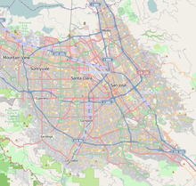
San Jose, California, is the third largest city in the state, and the largest of all cities in the San Francisco Bay Area and Northern California, with a population of 1,021,795.

The Santa Teresa Hills are a range of mountains in Santa Clara County, California, located primarily in the city of San Jose. They separate the San Jose neighborhoods of Almaden Valley to the west and Santa Teresa to the east.
The Berreyesa family is a prominent Californio family of Northern California. Members of the family held extensive rancho grants across the Bay Area during 18th and 19th centuries. Numerous places are named after the family, including the Berryessa district of San Jose and Lake Berryessa in Napa County.
José de los Reyes Berreyesa, also spelled Berrelleza, was born at Mission Santa Clara de Asís in Las Californias province of the Spanish Viceroyalty of New Spain.
Rancho San Juan Bautista was a 8,880-acre (35.9 km2) Mexican land grant in present-day Santa Clara County, California given in 1844 by Governor Manuel Micheltorena to José Agustín Narvaez. The grant extended along the Guadalupe River from Los Gatos to San Jose. Within its boundaries were much of today’s Willow Glen, Hillsdale, Robertsville and the Lone Hill area.

Oak Hill Memorial Park is a cemetery in San Jose, California, United States. Founded in 1847, it is the oldest secular cemetery in California. Oak Hill is the northernmost hill in the San Juan Bautista Hills of South San Jose.

This timeline of the Portolá expedition tracks the progress during 1769 and 1770 of the first European exploration-by-land of north-western coastal areas in what became Las Californias, a province of Spanish colonial New Spain. Later, the region was administratively-split into Baja and Alta. The first section of the march was on the Baja California peninsula, and the northern section of the expedition's trail was in today's US state of California.
Alférez Juan Prado Mesa was a prominent Californio military commander in Alta California. He was born a subject of the Spanish Empire, and performed his military duties as an officer of the Republic of Mexico,

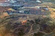
Communications Hill is a neighborhood located in the San Juan Bautista Hills of San Jose, California.
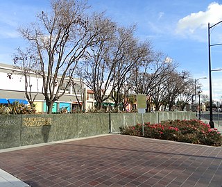
Parque de los Pobladores is a park in the SoFA District of Downtown San Jose, California.