
Luis Muñoz Marín International Airport is a joint civil-military international airport located in suburban Carolina, Puerto Rico, three miles (5 km) southeast of San Juan. It is named for Luis Muñoz Marín, Puerto Rico's first democratically elected governor, and was known as Isla Verde International Airport until it was renamed in February 1985. It is the busiest airport in the Caribbean region by passenger traffic. Over 4 million passengers boarded a plane at the airport per year according to the Federal Aviation Administration, making it the 48th busiest airport overseen by said federal agency.

Fernando Luis Ribas Dominicci Airport, also commonly known as Isla Grande Airport, is an airport in Isla Grande, a district in the municipality of San Juan, Puerto Rico. It is owned by the Puerto Rico Ports Authority and is adjacent to the Puerto Rico Convention Center, the San Juan Bay, and the Pan American Cruise Ship Terminal, and overlooks Cataño. While Isla Grande's main activity is general aviation, it is still a commercial airport, handling domestic and international commercial flights.
Palenque was a Maya city state in southern Mexico that flourished in the 7th century.

Around 99.2% of Colombians speak the Spanish language. Sixty-five Amerindian languages, two Creole languages, the Portuguese language and the Romani language are also spoken in the country. English has official status in the San Andrés, Providencia and Santa Catalina Islands.
Mahates is a river town and municipality located in the Bolívar Department, northern Colombia. The town of Mahates was founded on April 17, 1533 by Spanish conquistador Pedro de Heredia.

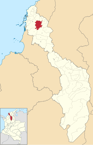
San Luis de Palenque is a town and municipality in the Department of Casanare, Colombia. The town is on a bend of the Pauto River, a tributary of the Meta River.

San Basilio de Palenque or Palenque de San Basilio, often referred to by the locals simply as Palenke, is a Palenque village and corregimiento in the Municipality of Mahates, Bolivar in northern Colombia. Palenque was the first free African town in the Americas, and in 2005 was declared a Masterpiece of the Oral and Intangible Heritage of Humanity by UNESCO.

Captain Luis Francisco Gómez Niño Air Base (Spanish: Base Aérea Capitán Luis Francisco Gómez Niño, also known as Apiay Air Base, is a Colombian military base assigned to the Colombian Aerospace Force Combat Air Command No. 2. It also hosts members of the Colombian Army and Colombian Navy. The base is located in Apiay, near the city of Villavicencio, in the Department of Meta in central Colombia, by the steps of the Andes mountain range and the plains of the Colombian Llanos.

San Carlos de Bariloche Airport, also known as Teniente Luis Candelaria Airport, is an international airport serving the city of San Carlos de Bariloche, Río Negro, Argentina. The airport covers an area of 1,810 hectares and has a 12,000-square-metre (130,000 sq ft) terminal; it is located 13 kilometres (8.1 mi) out of the city.
Brigadier Mayor César Raúl Ojeda Airport is an airport in San Luis Province, Argentina serving the city of San Luis. It is operated by Aeropuertos Argentina 2000.

San Luis Airport is a high-elevation airport serving Ipiales, a city in the Nariño Department of Colombia. The airport is 4 kilometres (2.5 mi) north of the city.

Jorge Enrique González Torres Airport is an airport serving San José del Guaviare, the capital of the Guaviare Department of Colombia. The runway is just north of the town and parallels the Guaviare River.
Villa Reynolds Airport is a joint military/general aviation airport serving Villa Mercedes, a city in the San Luis Province of Argentina. It is 8 kilometres (5.0 mi) southeast of Villa Mercedes, in Villa Reynolds, a village serving an Argentine Air Force base.
Valle del Conlara Airport is an international airport serving Santa Rosa de Conlara, a town in the San Luis Province of Argentina. The airport is in the countryside 5 kilometres (3 mi) southeast of the town. It also serves the city of Merlo, 16 kilometres (10 mi) to the east.

Palenque International Airport is an international airport in Palenque, Chiapas, Mexico. It serves international air traffic for the northern Chiapas region, including Palenque, serving domestic flights and supporting tourism, flight training, and general aviation activities.
San Marcos Airport is an airport serving the town of San Marcos, in the Sucre Department of Colombia. The runway is 4 kilometres (2.5 mi) northwest of the town.
San Bernardo Airport is an airport serving the city of Santa Cruz de Mompox, or Mompós, in the Bolívar Department of Colombia. The airport is 2 kilometres (1.2 mi) northwest of the town, near the Brazo De Mompos River, an arm of the Magdalena River.
Carmen de Bolívar Airport, also called Montemariano Airport is an airport serving the town of El Carmen de Bolívar and the Montes de Maria subregion, in the Bolívar Department of Colombia. The airport is 3 kilometres (1.9 mi) south of the town.It was conceived by Mr. José Luís Salcedo Padrón and Mr. Juan Federico Holman. In the 1930s it was called José Luis Salcedo Airport. In 2017, together with resources from the national level and the government of Bolívar, work began on its reconstruction after several decades of use by the guerrillas. During the government of President Iván Duque, the works that allowed its reopening were completed.

AeroTal was a Colombian airline based in the La Vanguardia Airport of Villavicencio. The airline specialized in both regional, domestic and international flights. It was founded in 1970 and completed its entire operations by 1983.
