
Sirmione is a comune in the province of Brescia, in Lombardy. It is bounded by Desenzano del Garda (Lombardy) and Peschiera del Garda in the province of Verona and the region of Veneto. It has a historical centre which is located on the Sirmio peninsula that divides the lower part of Lake Garda.

Albino is a comune in the province of Bergamo, in Lombardy, northern Italy. It is located northeast of Bergamo and is situated in the valley of the river Serio. The comune is included in the perimeter of the Alpine Convention international treaty.
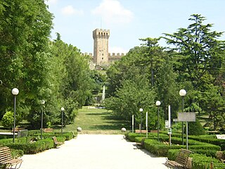
Este is a town and comune of the Province of Padua, in the Veneto region of northern Italy. It is situated at the foot of the Euganean Hills. The town is a centre for farming, crafts and industry worthy of note.

Poggibonsi is a town in the province of Siena, Tuscany, Central Italy. It is located on the River Elsa and is the main centre of the Valdelsa Valley.

Lauria is a town and comune of the province of Potenza, in Basilicata, southern Italy, situated near the borders of Calabria. It is a walled, medieval town on the steep side of a hill, with another portion of municipal territory in the plain below.

Sinalunga is a town and comune in the province of Siena, in the Tuscany region of central Italy.

Borgo a Mozzano is a town and comune in the province of Lucca, in northern Tuscany (Italy), located on the Serchio River.

Capannori is an Italian town and comune in the province of Lucca, in northern Tuscany.

Sant'Angelo dei Lombardi is a town and comune in the province of Avellino in the Campania region of southern Italy. It has been a historical spot of significance in mezzogiorno history.

Fara San Martino is a comune and town in the Province of Chieti in the Abruzzo region of Italy. Situated on the outskirts of the Majella National Park, in Abruzzo, the town is known as ‘La capitale della Pasta”.

Lama dei Peligni is a comune and town in the province of Chieti in the Abruzzo region of Italy with 1,155 inhabitants. It is also part of the Aventino-Medio Sangro mountain community and the municipal territory is included in the Maiella National Park. The town, known to naturalists as the country of chamois, is located in a florofaunal area of particular interest.

Castelleone di Suasa is a town and comune within the Province of Ancona, in the Marche region of Italy.

Agrate Conturbia is a comune (municipality) in the Province of Novara, in the Italian region of Piedmont, located about 100 kilometres (62 mi) northeast of Turin and about 25 kilometres (16 mi) north of Novara. It consists of two towns, Agrate and Conturbia, located in the low hills between Cressa and Borgo Ticino, south of Lake Maggiore.

San Martin de Tor is a comune (municipality) and a village in South Tyrol in northern Italy, located about 45 kilometres (28 mi) northeast of the city of Bolzano.
Montemagno is a comune (municipality) in the Province of Asti in the Italian region Piedmont, located about 50 kilometres (31 mi) east of Turin and about 13 kilometres (8 mi) northeast of Asti. As of 31 December 2010 it had a population of 1,228 and an area of 15.9 square kilometres (6.1 sq mi).
Arcore is a comune (municipality) in the Province of Monza and Brianza in the Italian region of Lombardy, about 20 kilometres (12 mi) northeast of Milan. It's situated on the banks of River Lambro.

Adrara San Rocco is an Italian town in the province of Bergamo, in the administrative region of Lombardy. The town is located about 25 kilometres (16 mi) east of Bergamo and is situated in the Guerna river valley. The town is part of the Mountain Community of Monte Bronzone Sebino.
Farra di Soligo is a comune (municipality) in the Province of Treviso in the Italian region Veneto, located about 50 kilometres northwest of Venice and about 25 km (16 mi) northwest of Treviso and borders the following municipalities: Follina, Miane, Moriago della Battaglia, Pieve di Soligo, Sernaglia della Battaglia, Valdobbiadene, Vidor.

Campogalliano is a comune (municipality) of 8.804 inhabitants in the Province of Modena in the Italian region Emilia-Romagna, located about 45 kilometres (28 mi) northwest of Bologna and about 8 kilometres (5 mi) northwest of Modena.
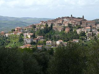
Seggiano is a comune (municipality) in the Province of Grosseto in the Italian region Tuscany, located about 100 kilometres (62 mi) south of Florence and about 40 kilometres (25 mi) northeast of Grosseto.


