
Hidalgo, officially the Free and Sovereign State of Hidalgo, is one of the 32 states which constitute the Federal Entities of Mexico. It is divided into 84 municipalities and its capital city is Pachuca de Soto.

Coatepec Harinas is a town and municipality in the State of Mexico, Mexico. The original name is "Coauhtepetl" which means 'serpent hill' in Náhuatl. Around 1825 because of a boom in flour production, the name "Harinas" was added.

Metepec is a city and municipality in the State of Mexico in Mexico and is located directly to the east of the state capital, Toluca, at an altitude of 2,635 metres (8,645 ft) above sea level. The centre of Mexico City lies some 50 km further to the east. The name Metepec comes from Náhuatl meaning hill of the maguey plants. However, it is also known in the Matlatzinca language as "Nepinta-Tuhi" meaning 'people of corn land' and in the Otomi language as "Ntaguada".
Huauchinango is a city in Huauchinango Municipality located in the far north of the state of Puebla in central Mexico. It is located in the rugged Sierra Norte de Puebla mountain region, filled with peaks, ravines and rivers that form waterfalls. The city is home to a locally venerated image called the Señor del Santo Entierro and also to the area's main commercial fair, the Feria de las Flores, which promotes the area's flower production, especially that of azaleas.

Atlacomulco is a city and municipality located in the northwest of the State of Mexico in central Mexico, 63 kilometres (39 mi) from the state capital of Toluca. The name is derived from the Nahuatl phrase "atlacomulli" which means "where there are wells." The city, with a population of 20,477 is surrounded by rural area in which 75% of the rest of the municipality lives. The municipality has a sizable percentage of indigenous language speakers, mostly Mazahua. The Mazahua name for the area is Embaró, which means "colored rock." Agriculture is still the main economic activity, but the development of a number of industrial parks, such as Atlacomulco 2000, which allowed the seat to reach city statues by 1987. Atlacomulco is also the origin of a political organization called the "Atlacomulco Group" made up of powerful political figures who deny its existence.
The city and municipality of Tenango del Valle and its seat, Tenango de Arista, are located in the southern portion of the Valley of Toluca in Mexico State, about 72 km southwest of Mexico City and 25 km south of Toluca. While the seat is officially named Tenango de Arista, it is more commonly referred to as Tenango del Valle, as this was the original name of the town. Tenango del Valle is best known as the site of the Teotenango archeological site, which was a walled city inhabited from about 900 C.E. to 1550 C.E.

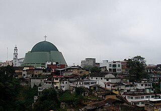
Zacatlán is a city and municipal seat of Zacatlán Municipality located in the Sierra Norte de Puebla region of Puebla in central Mexico. The area is known for its production of apples, other fruit, cider and fruit wines, which are promoted through the annual Feria de la Manzana and Festival de la Sidra. It is also home to the Relojes Centenario company, the first clock factory in Latin America and the builder of the city's double sided flower clock in the main square. The historic center of the city is filled with traditional houses with red tile roofs and Zacatlan was designated a “Pueblo Mágico” in 2011. Outside of the city proper, there is a significant indigenous population, the Piedras Encimadas Valley with its rock formations and various waterfalls and ravines.
Villa Guerrero is a town and municipality in the State of Mexico, Mexico. It is located on the southern slopes of the Nevado de Toluca, also known as Xinantecatl, and is 50 minutes/58 km from Toluca.
Ixtapan del Oro is a town and municipality in the State of Mexico, in Mexico. The name “Ixtapan” comes from Nahuatl and means 'in the place of little salt'. "del Oro" is Spanish, meaning 'of the gold'. This name was added in 1894 when some veins of gold were found here.
San Mateo Mexicaltzingo is a town and the seat of the municipality of Mexicaltzingo located in the State of Mexico, in Mexico. It is located near Toluca. Mexicaltzingo means from the Náhuatl “Place in where habits the honorable people”.
San Felipe del Progreso is a town and municipality in the northwest of the State of Mexico. It is in the western part of the state, 59 km from the state capital of Toluca and 72 km southwest of Atlacomulco. In colonial times, the village was founded as "San Felipe" or "San Felipe Ixtlahuaca". Later it was called "San Felipe el Grande" and "San Felipe del Obraje". In the second half of the 19th century, it received its current name of "San Felipe del Progreso."

Acatlán is a town and municipality located in the Mexican state of Hidalgo, about ten km northwest of the city of Tulancingo and 147 km from Mexico City. The main landmark is the San Miguel monastery which was built in the 16th century. It is partially in ruins but there have been efforts since the 1980s to restore it. Acatlán comes from a Nahuatl phrase which means “near the reeds”.

Tenango del Aire is a town and municipality located in the southeast portion of the State of Mexico and is about 42 km southeast of Mexico City. The municipality is bordered by Temamatla, Tlalmanalco, Juchitepec, and Ayapango. Despite the fact that this municipality is distinctly rural, it falls within the Mexico City Metropolitan Area. The name “Tenango del Aire” came about in two parts. Originally and until 1890, the town was known as Tenango de Topopula. “Tenango” means “walled in” or “fenced by stones.” The second part is due to visits by President Porfirio Diaz, who commented on the winds that are prevalent here. “del Aire” means “of the air.”
Juchitepec is a town and municipality in State of Mexico in central Mexico. Juchitepec means “Hill of the Flowers” in Nahuatl. The municipality covers an area of 149.56 km². It has one major community outside the seat called San Matias Cuijingo. The municipality is located at the southwest of the state, and borders the municipalities of Tenango del Aire, Tepetlixpa, Ozumba and Ayapango in the State of Mexico, and with Totolapan and Tlalnepantla in the state of Morelos to the south, and the borough of Milpa Alta in Mexico City to the west. A large part of the population is employed in commerce. Other major economic activities include agriculture and livestock. As of the 2010 census, the municipality had a total population of 23,497 inhabitants.
San Miguel Chimalapa is a town and municipality in Oaxaca in south-western Mexico. It is part of the Juchitán District in the west of the Istmo de Tehuantepec region.
San Miguel Panixtlahuaca is a town and municipality in Oaxaca in south-western Mexico. It is part of the Juquila District in the center of the Costa Region. The name "Panixtlahuatl" in the Nahuatl language means "Plain of the Bridge".
Santa María Chimalapa is a town and municipality in Oaxaca in south-western Mexico. It is part of the Juchitán District in the west of the Istmo de Tehuantepec region.

Zacatlán Municipality is a municipality in Puebla in south-eastern Mexico.

Rayón is a municipality located in Toluca Region, the northeastern part of the state of Mexico in Mexico, the municipal seat is Santa María Rayón, formerly named Cuauhtenco. The municipality is located at a southern pass leading out of the Toluca Valley.

Tenango is a style of embroidery which originated in the Tenango de Doria municipality in the Mexican state of Hidalgo. It is a commercialized version of traditional Otomi embroidery, which was developed in the 1960s in response to an economic crisis. It is estimated at over 1,200 artisans practice the craft in Tenango de Doria and the neighborhing municipality of San Bartolo Tutotepec.
