
The Baja California Peninsula is a peninsula in Northwestern Mexico. It separates the Pacific Ocean from the Gulf of California. The peninsula extends 1,247 km from Mexicali, Baja California in the north to Cabo San Lucas, Baja California Sur in the south. It ranges from 40 km at its narrowest to 320 km at its widest point and has approximately 3,000 km of coastline and approximately 65 islands. The total area of the Baja California Peninsula is 143,390 km2 (55,360 sq mi), roughly the same area as the country of Nepal.

The Gulf of California, also known as the Sea of Cortés or less commonly as the Vermilion Sea, is a marginal sea of the Pacific Ocean that separates the Baja California Peninsula from the Mexican mainland. It is bordered by the states of Baja California, Baja California Sur, Sonora, and Sinaloa with a coastline of approximately 4,000 km (2,500 mi). Rivers that flow into the Gulf of California include the Colorado, Fuerte, Mayo, Sinaloa, Sonora, and the Yaqui. The surface of the gulf is about 160,000 km2 (62,000 sq mi). Maximum depths exceed 3,000 meters (9,800 ft) because of the complex geology, linked to plate tectonics.
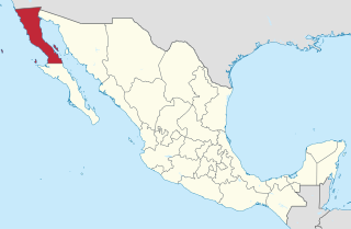
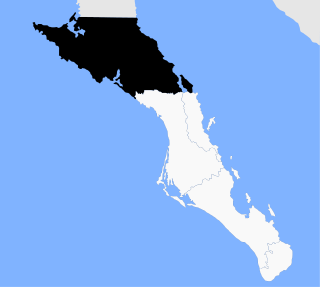
Baja California (Spanish pronunciation: [ˈbaxa kaliˈfoɾnja];, officially the Free and Sovereign State of Baja California, also called Baja California Norte, is a state in Mexico. It is the northernmost and westernmost of the 32 federal entities of Mexico. Before becoming a state in 1952, the area was known as the North Territory of Baja California. It has an area of 70,113 km2 and comprises the northern half of the Baja California Peninsula, north of the 28th parallel, plus oceanic Guadalupe Island. The mainland portion of the state is bordered on the west by the Pacific Ocean; on the east by Sonora, the U.S. state of Arizona, and the Gulf of California; on the north by the U.S. state of California; and on the south by Baja California Sur.

Baja California Sur, officially the Free and Sovereign State of Baja California Sur, is the second-smallest Mexican state by population and the 31st admitted state of the 32 states which make up the 32 Federal Entities of Mexico. It is also the ninth-largest Mexican state in terms of area.

La Paz is the capital city of the Mexican state of Baja California Sur and an important regional commercial center. The city had a 2020 census population of 250,141 inhabitants, making it the most populous city in the state. Its metropolitan population is somewhat larger because of the surrounding towns, such as El Centenario, Chametla and San Pedro. It is in La Paz Municipality, which is the fourth-largest municipality in Mexico in geographical size and reported a population of 292,241 inhabitants on a land area of 20,275 km2 (7,828 sq mi).

Cabo San Lucas, or simply Cabo, is a resort city at the southern tip of the Baja California Peninsula, in the Mexican state of Baja California Sur. As at the 2020 Census, the population of the city was 202,694 inhabitants. Cabo San Lucas together with San José del Cabo is known as Los Cabos. Together, they form a metropolitan area of 351,111 inhabitants.

Mulegé is an oasis town in the Mexican state of Baja California Sur, situated at the mouth of the Río de Santa Rosalía. It is the fourth-largest community in Mulegé Municipality. It had a population of 3,821 according to the Mexican federal census of 2010.

San Quintín is a coastal town on the west coast of the Mexican state of Baja California, in the Municipality of San Quintin, some 190 km (118 mi.) south of the city of Ensenada on Mexican Federal Highway 1. The town is also in the middle of an important agricultural area, especially for growing strawberries and tomatoes. The largest nearby locality is Lázaro Cardenas, home to 16,294 people as of the 2010 census. The whole area houses roughly 25,000 people, up from 20,000 in 2000. This is the largest population cluster south of Ensenada within the state.

Los Cabos is a municipality located at the southern tip of Mexico's Baja California Peninsula, in the state of Baja California Sur. It encompasses the two towns of Cabo San Lucas and San José del Cabo linked by a twenty-mile Resort Corridor of beach-front properties and championship golf courses.

Federal Highway 1 is a free (libre) part of the federal highway corridors of Mexico, and the highway follows the length of the Baja California Peninsula from Tijuana, Baja California, in the north to Cabo San Lucas, Baja California Sur, in the south. The road connects with Via Rapida, which merges into the American Interstate 5 (I-5) at the San Ysidro Port of Entry, which crosses the international border south of San Ysidro, California.
Mulegé is the northernmost municipality of the Mexican state of Baja California Sur. It is the largest municipality by area in the state and in Mexico, with an area of 33,092.20 km2. In the 2020 Census, it had a population of 64,022 inhabitants. Isla Natividad is part of the municipality.

Hurricane Nora was only the third tropical cyclone on record to reach Arizona as a tropical storm, and one of the rare cyclones to make landfall in Baja California. Nora was the fourteenth named tropical cyclone and seventh hurricane of the 1997 Pacific hurricane season. The September storm formed off the Pacific coast of Mexico, and aided by waters warmed by the 1997–98 El Niño event, eventually peaked at Category 4 intensity on the Saffir–Simpson hurricane scale.

The arch of Cabo San Lucas, is a distinctive rock formation at the southern tip of Cabo San Lucas, which is itself the extreme southern end of Mexico's Baja California Peninsula. The arch is locally known as "El Arco," which means "the arch" in Spanish, or "Land's End."

Todos Santos is a small coastal town in the foothills of the Sierra de la Laguna Mountains, on the Pacific coast side of the Baja California Peninsula, about an hour's drive north of Cabo San Lucas on Highway 19 and an hour's drive southwest from La Paz. Todos Santos is located very near the Tropic of Cancer in the municipality of La Paz. The population was 6,485 at the census of 2015. It is the second-largest town in the municipality.

El Pescadero is a small village in the municipality of La Paz in the Mexican state of Baja California Sur. It is located at km 64 on Federal Highway 19 on the Pacific Ocean about 8 kilometers South of Todos Santos which is about a one-hour drive north of Cabo San Lucas. The Mexican census of 2015 reported a population of 3,151 inhabitants.

The Spanish missions in Baja California were a large number of religious outposts established by Catholic religious orders, the Jesuits, the Franciscans and the Dominicans, between 1683 and 1834 to spread the Christian doctrine among the Native Americans or Indians living on the Baja California peninsula. The missions gave Spain a valuable toehold in the frontier land, and introduced European livestock, fruits, vegetables, and industry into the region. The Indians were severely impacted by the introduction of European diseases such as smallpox and measles and by 1800 their numbers were a fraction of what they had been before the arrival of the Spanish.
The 1934 Pacific hurricane season ran through the summer and fall of 1934. Before the satellite age started in the 1960s, data on east Pacific hurricanes was extremely unreliable. Most east Pacific storms were of no threat to land.

Los Barriles is a town in La Paz Municipality, Baja California Sur, Mexico. It is situated along Highway 1, 40 miles (64 km) north of San José del Cabo and 65 miles (105 km) south of La Paz. Punta Pescadero Airstrip is 9 miles (14 km) to the north; Rancho Leonero, a vacation resort, is to the south. Adjacent to Buenavista, the rural towns straddle the head of Bahía las Palmas on the Gulf of California, where winter westerlies average 20–25 knots. Los Barriles is within the transition area of the Baja California peninsula's Sierra de la Laguna where the hills become sandy flats.

Hurricane Lorena was a strong Pacific hurricane in September 2019 that brought heavy rainfall, flooding, and mudslides to Southwestern Mexico and the Baja California Peninsula and also brought severe weather to the U.S. state of Arizona. Lorena was the thirteenth named storm and seventh and final hurricane of the 2019 Pacific hurricane season. A tropical wave, originally from the North Atlantic, entered the East Pacific basin on September 16. With increasing thunderstorm development, Lorena formed as a tropical storm on September 17 alongside Tropical Storm Mario. Lorena made its passage northwestward and quickly gained strength before it made landfall as a Category 1 hurricane in Jalisco on September 19. Due to interaction with the mountainous terrain, Lorena weakened back to a tropical storm. After moving into the warm ocean temperatures of the Gulf of California, however, Lorena re-strengthened into a hurricane, and reached its peak intensity with 1-minute sustained winds of 85 mph and a minimum barometric pressure of 985 millibars Lorena made a second landfall in the Mexican state of Baja California Sur, and quickly weakened thereafter. Lorena weakened to a tropical storm over the Gulf of California, and became a remnant low on September 22, shortly after making landfall in Sonora as a tropical depression. The remnant low moved inland over Mexico, and eventually dissipated inland over Arizona on September 24.