
Sal is an island in Cape Verde. Sal is a tourist destination with white sandy beaches and over 350 days of sunshine a year. It is one of the three sandy eastern islands of the Cape Verde archipelago in the central Atlantic Ocean, 350 mi (560 km) off the west coast of Africa. Cabo Verde is known for year-round kiteboarding, for the large reserve of Caretta turtles which hatch from July to September, and the music of Cesaria Evora.

Boa Vista, also written as Boavista, is a desert-like island that belongs to the Cape Verde Islands. At 631.1 km2 (243.7 sq mi), it is the third largest island of the Cape Verde archipelago.
São Miguel is a concelho (municipality) of Cape Verde. It is situated in the northeastern part of the island of Santiago. Its seat is the city Calheta de São Miguel. Its population was 15,648 at the 2010 census, and its area is 77.4 km2. The municipality was created in 1996, when a parish of the older Municipality of Tarrafal was separated to become the Municipality of São Miguel.

Mosteiros is a concelho (municipality) of Cape Verde. Situated in the northeastern part of the island of Fogo, it covers 19% of the island area, and is home to 26% of its population. Its seat is the city Mosteiros (Igreja). Its population was 9,524 at the 2010 census, and its area is 89.45 km2.

São Lourenço dos Órgãos is a concelho (municipality) of Cape Verde. It is situated in the mountainous central part of the island of Santiago. Its seat is the city João Teves. Its population was 7,388 at the 2010 census, and its area is 36.9 km2. The municipality is bordered by Santa Cruz to the northeast, São Domingos to the south, Ribeira Grande de Santiago to the southwest and São Salvador do Mundo to the northwest. Pico de Antónia, the island's highest mountain, straddles the borders of São Lourenço dos Órgãos, São Salvador do Mundo and Ribeira Grande de Santiago.

São Salvador do Mundo is a concelho (municipality) of Cape Verde. It is situated in the central part of the island of Santiago. Its seat is the city Picos. Its population was 8,677 at the 2010 census, and its area is 26.5 km2, making it the smallest municipality of Cape Verde. The municipality borders Santa Cruz to the northeast, São Lourenço dos Órgãos to the southeast, Ribeira Grande de Santiago to the southwest and Santa Catarina to the northwest.

Tarrafal de São Nicolau is a concelho (municipality) of Cape Verde. Situated in the western part of the island of São Nicolau, it covers 35% of the island area (119.8 km²) and is home to 41% of its population. Its seat is the town Tarrafal de São Nicolau.

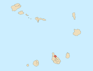
Sal Rei is a city on the northwestern coast of the island of Boa Vista in eastern Cape Verde. Sal Rei is the island's main urban settlement, and the seat of the Boa Vista Municipality. In 2010 its population was 5,778. The name of the settlement means "Salt King" in Portuguese. This name stems from when the island's main industry was salt production.

Rabil is a town on the island of Boa Vista, Cape Verde. It was the island's former capital. Rabil is the island's second largest town, located 6 kilometres (3.7 mi) southeast of the island capital of Sal Rei. Its population was 1,248 in 2010. The island's airport, Aristides Pereira International Airport, is situated northwest of the town.
São João Baptista is a freguesia of Cape Verde. It covers the eastern part of the island of Brava. The parish seat is Nova Sintra. To its west is the parish of Nossa Senhora do Monte.
Nossa Senhora da Lapa is a freguesia of Cape Verde. It covers the smaller northwestern part of the municipality of Ribeira Brava, on the island of São Nicolau.
Nossa Senhora do Monte is a freguesia of Cape Verde. It covers the western part of the island of Brava. To its east is the parish of São João Baptista.

Nossa Senhora da Conceição is a freguesia of Cape Verde. It covers the southern part of the municipality of São Filipe, on the island of Fogo. The freguesia consists of the following settlements:

São Nicolau Tolentino is a freguesia of Cape Verde. It covers the western part of the municipality of São Domingos, on the island of Santiago.

Nossa Senhora do Livramento is a freguesia of Cape Verde. It covers the northern part of the municipality of Ribeira Grande, on the island of Santo Antão.
Nossa Senhora do Rosário is a freguesia of Cape Verde. It covers the eastern part of the municipality of Ribeira Grande, on the island of Santo Antão.
Santo Crucifixo is a freguesia of Cape Verde. It covers the southern part of the municipality of Ribeira Grande, on the island of Santo Antão. The seat of the parish is Coculi. The parish covers much of the Ribeira Grande valley.
São João Baptista is a freguesia of Cape Verde. It covers the larger, southern part of the municipality of Porto Novo, on the island of Santo Antão.
São Pedro Apóstolo is a freguesia of Cape Verde. It covers the western part of the municipality of Ribeira Grande, on the island of Santo Antão.
Nossa Senhora do Rosário is a freguesia of Cape Verde. It covers the larger eastern part of the municipality of Ribeira Brava, on the island of São Nicolau.


