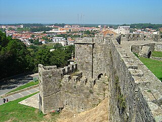
Santa Maria da Feira is a city and a municipality in Aveiro District in Portugal, 23 km from central Porto. The population in 2011 was 139,309, in an area of 215.88 km².

São João da Madeira, is a city and a municipality in northwestern region of the Portuguese Norte region. It's part of the larger Porto Metropolitan Area, located 30 km from central Porto. The population in 2011 was 21,713. With an area of 7.94 km², it is the smallest municipality in Portugal. In 2010, the city was distinguished in Portuguese Quality of Life studies as the "Best Municipality to Live In".

Águeda is a city and a municipality in Portugal. According to the Portuguese 2011 census, the municipality of Águeda had 47,729 inhabitants, in an area of 335.27 km2. The city proper had a population of 14,504, while the remainder is distributed in 11 parishes, within the Baixo Vouga Subregion.
Vale de Cambra is a city and a municipality in Portugal. The population in 2011 was 22,864, in an area of 147.33 km2. It had 21,440 electors in 2006. The city itself has about 4,100 inhabitants and is located in the Vila Chã, Codal e Vila Cova de Perrinho parish.

The Turduli Veteres, translated as "Ancient Turduli" or "Old Turduli" were an ancient pre-Roman tribe of present day Portugal, akin to the Calaicians or Gallaeci and Lusitanians.
Douro Litoral is a historical province of Portugal. It is centered on the city of Porto, now the capital of the Norte Region. Other important cities in the province are Vila Nova de Gaia, Matosinhos, Maia, Póvoa de Varzim, and the historically important Penafiel, Amarante, Feira, Vila do Conde.

Grande Porto or Greater Porto is a former Portuguese NUTS3 subregion, integrating the NUTS2 region of Norte, in Portugal. It was abolished at the January 2015 NUTS 3 revision.

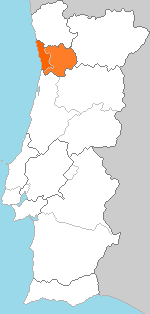
Entre Douro e Vouga was a former NUTS3 Portuguese subregion. It was abolished at the January 2015 NUTS 3 revision. It is now part of Metropolitan Area of Porto - NUTS3, integrated in the NUTS2 Norte Region. Its name stood for the fact that it covered an area between the Douro River and Vouga River. It was bordered in the north by Grande Porto Subregion and Tâmega Subregion and in the south by the Centro Region.

Beira Litoral is a former province (província) of Portugal, formally instituted in an administrative reform of 1936. It was abolished with the 1976 Constitution of Portugal.

Linha do Vouga(the Vouga line) is the last surviving metre gauge railway line in Portugal still operated by Comboios de Portugal. The other remaining metre gauge lines all closed in 2009. The line is, however, also under the threat of closure.
Sangalhos is a town and a civil parish in the municipality of Anadia, Portugal. The population in 2011 was 4,068, in an area of 16.90 km².
Agadão is a Portuguese civil parish located in Águeda Municipality in the Baixo Vouga Subregion. Its population was less than 500 inhabitants from the 2001 census, in an area of 35.34 km2 ; it is the second largest parish in area, penultimate center of population.

Portugal formerly had several hundred kilometres of narrow-gauge railways, but by 2010 only two lines were still in operation – the Vouga line and the Metro de Mirandela. The lines were operated by Comboios de Portugal and maintained by REFER.

Trofa, Segadães e Lamas do Vouga is a freguesia in Águeda Municipality, Aveiro District, Portugal. The population in 2011 was 4,630, in an area of 16.07 km2. The Ponte do Cabeço do Vouga and the Igreja de Trofa are located in this freguesia.
Infraestruturas de Portugal, S.A. (IP) is a state-owned company which resulted from the merger of Rede Ferroviária Nacional (REFER) and Estradas de Portugal (EP). It manages the Portuguese rail and road infrastructure.
Susana Correia is a Portuguese politician. As a member of the Portuguese Socialist Party (PS), she has been a deputy in the Portuguese Assembly of the Republic since 2019.

