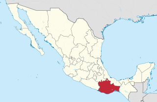
Oaxaca, officially the Free and Sovereign State of Oaxaca, is one of the 32 states that compose the Federative Entities of Mexico. It is divided into 570 municipalities, of which 418 are governed by the system of usos y costumbres with recognized local forms of self-governance. Its capital city is Oaxaca de Juárez.

Oaxaca is a state in Southwest Mexico that is divided into 570 municipalities, more than any other state in Mexico. According to Article 113 of the state's constitution, the municipalities are grouped into 30 judicial and tax districts to facilitate the distribution of the state's revenues. It is the only state in Mexico with this particular judicial and tax district organization. Oaxaca is the tenth most populated state with 4,132,148 inhabitants as of the 2020 Mexican census and the fifth largest by land area spanning 93,757.6 square kilometres (36,200.0 sq mi).

Puerto Escondido is a small port and tourist center in the municipality of San Pedro Mixtepec Distrito 22 in the Mexican state of Oaxaca. Prior to the 1930s, there was no town. The bay had been used as a port intermittently to ship coffee, but there was no permanent settlement due to the lack of potable water. The name "Puerto Escondido" had roots in the legend of a woman who escaped her captors and hid here. The Nahuatl word for this area was Zicatela, meaning “place of large thorns". Today, it refers to the area's most famous beach.

Santa María del Tule is a town and a municipality in the Mexican state of Oaxaca. It is part of the Centro District in the Valles Centrales region. It is located 11 kilometers (6.8 mi) SE of the city of Oaxaca on Highway 190. The town and municipality are named for the patron saint of the place, the Virgin Mary and “Tule” comes from the Náhuatl word “tulle” or “tullin” which means bulrush.
Santa María, Oaxaca may refer to:

Santa María Jaltianguis is a town and municipality in Oaxaca in south-western Mexico. The municipality covers an area of km². It is part of the Ixtlán District in the Sierra Norte region.
Santa María Tlahuitoltepec is a town and municipality in Oaxaca in south-western Mexico. The municipality covers an area of km². It is part of the Sierra Mixe district within the Sierra Norte de Oaxaca Region.

Ixtlán District is located in the Sierra Norte region, in the northeastern area of the State of Oaxaca, Mexico.

Centro District is located in the Valles Centrales Region of the State of Oaxaca, Mexico. The district includes the state capital Oaxaca and satellite towns. The district has an average elevation of 1,550 meters. The climate is mild, with average temperatures ranging from 16°C in Winter to 25°C in spring.

Tlacolula District is located in the east of the Valles Centrales Region of the State of Oaxaca, Mexico.

Putla District is located in the west of the Sierra Sur Region of the State of Oaxaca, Mexico.

Sola de Vega District is located in the Sierra Sur Region of the State of Oaxaca, Mexico. The district center is Villa Sola de Vega.

Teotitlán District is located in the north of the Cañada Region of the State of Oaxaca, Mexico.

Cuicatlán District is located in the south of the Cañada Region of the State of Oaxaca, Mexico. The district includes 20 municipalities, bringing together a total of 233 settlements.

Jamiltepec District is located in the west of the Costa Region of the State of Oaxaca, Mexico.

Pochutla District is located in the east of the Costa Region of the State of Oaxaca, Mexico. The primary city is San Pedro Pochutla.

Tlaxiaco District is located in the south of the Mixteca Region of the State of Oaxaca, Mexico. The main city is the Heroic City of Tlaxiaco

Huajuapan District is located in the north of the Mixteca Region of the State of Oaxaca, Mexico. The principal city is Huajuapan de León.

The Indigenous people of Oaxaca are descendants of the inhabitants of what is now the state of Oaxaca, Mexico who were present before the Spanish invasion. Several cultures flourished in the ancient region of Oaxaca from as far back as 2000 BC, of whom the Zapotecs and Mixtecs were perhaps the most advanced, with complex social organization and sophisticated arts.
Huamelultec is one of the Chontal languages of Oaxaca, Mexico. It is spoken in the Oaxacan municipalities of San Pedro Huamelula, Santiago Astata, and Tehuantepec . The name has been misspelled Tlamelula.


