Samoan mythology tells stories of many different deities. There were deities of the forest, the seas, rain, harvest, villages, and war. There were two types of deities, atua, who had non-human origins, and aitu, who were of human origin.

Savaiʻi is the largest and highest island in Samoa and the Samoan Islands chain. The island is the sixth largest in Polynesia, behind the three main islands of New Zealand and the Hawaiian Islands of Hawaii and Maui.

Salelologa is a village district at the east end of Savai'i island in Samoa. It is the main entry point into the island with the only ferry terminal on Savai'i. It also serves as the main township for shopping and public amenities with a market selling fresh produce and arts and crafts.

Falealupo is a village in Samoa situated at the west end of Savai'i island 20 miles (32 km) from the International Date Line used until December 29, 2011. The village has two main settlements, Falealupo-Uta, situated inland by the main island highway and Falealupo-Tai, situated by the sea. The road to the coastal settlement is about 9 km, most of it unsealed, from the main highway.

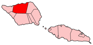
Gaga'emauga is a district on the island of Savai'i in Samoa. The district is situated on the central north side of Savai'i. The name Gaga'emauga literally means "near side of the mountain", meaning the eastern side of the mountain chain running through the centre of Savai'i Island.

Gaga'ifomauga is a political district on the island of Savai'i in Samoa. The district is situated on the northern side of the island with a population of 4,878.
Matautu is the name of different villages in Samoa. Places named Matautu are found on the two largest islands, Upolu and Savai'i.

Satapuala is a village situated on the north west coast Upolu island in Samoa. The village is part of A'ana Alofi III Electoral Constituency which forms part of the larger political district A'ana.

Not to be confused with Fagamalo, American Samoa

Mt Matavanu is an active volcano on the island of Savai'i in Samoa.

Safotu is a village on the central north coast of Savai'i island in Samoa. Safotu is in the district Gagaifomauga. Traditionally, it attained the status of 'Pule,' customary political authority, and has been the main centre of the Gagaifomauga district.

Samauga is a village on the central north coast of Savai'i island in Samoa. The village is in the electoral district of Gagaifomauga.

Manase is a village on the central north coast of Savai'i island in Samoa in the political district of Gagaifomauga. Situated by the sea with a white sandy beach, Manase has become a popular tourist destination since the 1990s with low budget and locally owned beach fale accommodation.

Archaeology of Samoa began with the first systematic survey of archaeological remains on Savai'i island by Jack Golson in 1957. Since then, surveys and studies in the rest of Samoa have uncovered major findings of settlements, stone and earth mounds including star mounds, Lapita pottery remains and pre-historic artifacts.

Mauga is a village in Savai'i island in Samoa. The word mauga means mountain in the Samoan language. The settlement is built around the crater of a small volcano. Mauga is in the Gaga'emauga political district near the central north coast of the island. The large meeting houses of the village are situated in a circle facing each other around the rim of the crater which can be seen in high altitude photography.

Avao is a village on the north central coast of Savai'i island in Samoa. The village is part of the electoral constituency Gaga'emauga III, which is included in the larger political district of Gaga'emauga.

Lelepa is a village on the north central coast of Savai'i island in Samoa. The village is part of the electoral constituency Gaga'emauga III which forms part of the larger political district of Gaga'emauga.
Saleia is a village on the north central coast of Savai'i island in Samoa. The village is part of the electoral constituency Gaga'emauga III which forms part of the larger political district of Gaga'emauga.
Safa'i is a village on the north central coast of Savai'i island in Samoa. The village is part of the electoral constituency Gaga'emauga III which forms part of the larger political district Gaga'emauga.


