
Saharsa is a city and municipal corporation in the Saharsa District in the eastern part of the state of Bihar, India. It is situated near the eastern banks of the Kosi River. It serves as the administrative headquarters for the Saharsa District and is also the Divisional headquarters of the Kosi Division.
Supaul is a town and a municipality that is headquarters of Supaul district in the Indian state of Bihar. Supaul is the administrative headquarters of this district. There Are 11 block under the Supaul district Supaul, Kishanpur, Saraigarh-Bhaptiyahi, Pipra, Triveniganj, Raghopur, chhatapur, Nirmali, Marauna, Basantpur and pratapganj.

Madhepura district is one of the thirty-eight districts of Bihar state, India, and Madhepura town is the administrative headquarters of this district. Madhepura district is a part of Kosi division.

Darbhanga district is one of the thirty-eight districts of Bihar state in eastern India, and Darbhanga city is the administrative headquarters of this district and 5th largest city of Bihar as well. Darbhanga district lies in Historical Mithila region. Darbhanga district is a part of Darbhanga Division. The district is bounded on the north by Madhubani district, on the south by Samastipur district, on the east by Saharsa district and on the west by Sitamarhi and Muzaffarpur districts. The district covers an area of 2,279 km2 (880 sq mi).

Khagaria district is an administrative district in Mithila region in the state of Bihar in India. The district headquarters are located at Khagaria. Earlier it was a part of Munger District as a sub-division that was created in 1943–44. It was upgraded to the status of a district on 10 May 1981. Khagaria district is a part of Munger Division.

Supaul district is one of the thirty-eight districts of Bihar, India. The town Supaul is the district's administrative headquarters. The district, which was split from the former Saharsa district on 14 March 1991, occupies 2,410 km2 (931 sq mi).

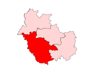
Saharsa is one of the thirty-eight districts of Bihar, India. Saharsa city is the administrative headquarters of this district. Saharsa district is a part of the Kosi Division and it became a district on 1 April 1954 and has subsequently become smaller with other districts being carved from it, most notably Madhepura in 1981.
Simri Bakhtiyarpur is a subdivision and town in the Saharsa district of Bihar state, India.
Dhabouli is a village located in Saharsa district of Bihar state, India.The total geographical area of Village is 2555.92 hectares. Madhepura Is nearest town to Dhabauli which is approximately 10 km away. The Primary Occupation Is Farming, but now many people have migrated to places like Delhi and Mumbai for work. A number of people of this village are also working in offices of the state, central governments of India and Private sector. More than 25000 people have been living here since the origin of this area. The Village has three panchayats and a population of more than 25,000. The village has good telecom connectivity. The village has also a branch of State Bank of India.

Sonbarsha Assembly constituency is an assembly constituency in Saharsa district in the Indian state of Bihar. It is reserved for scheduled castes from 2010. Earlier, it was an open seat.

25°52′14″N86°36′05″ESaharsa Assembly constituency is an assembly constituency in Saharsa district in the Indian state of Bihar.
Simri Bakhtiarpur Assembly constituency is an assembly constituency in Saharsa district in the Indian state of Bihar.

Mahishi Assembly constituency is an assembly constituency in Saharsa district in the Indian state of Bihar.
Biraul is the subdivisional headquarters of Biraul subdivision, consisting of six blocks of Darbhanga district in Bihar, India. The blocks are Biraul, Ghanshyampur, Gorabauram, Kiratpur, Kusheshwar Asthan and Kusheshwar Asthan East. This region covers the south-eastern part of Darbhanga district.
Uchhati is a village in the Biraul block of Biraul subdivision in Darbhanga district, Bihar, India. This is one of the populous villages in Biraul block. This is hardly one kilometer from Biraul block and two kilometers from Supaul Bazar (Darbhanga). Darbhanga is at a distance of 48 km from this village. The link road of Darbhanga-Saharsa via Biraul passes through this village.

Uttar Bihar Gramin Bank is a regional rural bank (RRB) in the State of Bihar, India. It is under the ownership of Ministry of Finance, Government of India. It is one of the largest regional rural banks in India in terms of branch network, staff strength and area of operation.
Nauhatta is a large village in Nauhatta Block in Saharsa District of Bihar state, India. It belongs to Kosi Division. It is located 20 km towards North from District headquarters Saharsa. 165 km from State capital Patna. It comes under Mahisi constituency. The village had a population of 25,347 of which 13,124 were male while 12,223 were females as per Population Census 2011.
Rajdham is a village in Gogari block of Khagaria district of Bihar State, India.
Sabaila is a village in Saharsa District, Bihar, India.