Madhepura is a municipality in Madhepura district in the Indian state of Bihar. It stands at the centre of Kosi ravine, It was called Madhyapura- a place centrally situated which was subsequently transformed as Madhipura into present Madhepura. It is surrounded by Araria and Supaul districts in the north, Khagaria and Bhagalpur districts in the south, Purnia district in the east and Saharsa district in the West.

Saharsa is a city in the Saharsa District in the eastern part of the state of Bihar, India. It is situated near the eastern banks of the Kosi River. It serves as the administrative headquarters for Saharsa District and is also the Divisional Headquarter of the Kosi Division.

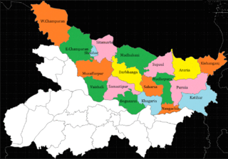
Madhepura district is one of the thirty-eight districts of Bihar state, India, and Madhepura town is the administrative headquarters of this district. Madhepura district is a part of Kosi division.

Khagaria district is an administrative district in the state of Bihar in India. The district headquarters are located at Khagaria. Earlier it was a part of Munger District as a sub-division that was created in 1943–44. It was upgraded to the status of a district on 10 May 1981. Khagaria district is a part of Munger Division.

Saharsa is one of the thirty-eight districts of Bihar, India. Saharsa city is the administrative headquarters of this district. Saharsa district is a part of the Kosi Division and it became a district on 1 April 1954 and has subsequently become smaller with other districts being carved from it, most notably Madhepura in 1981.
Simri Bakhtiyarpur is a subdivision and town in the Saharsa district of Bihar state, India.
Maheshkhunt is a village in Khagaria district of Bihar state, India.
Chainpur is one of the largest villages of Saharsa District in the Indian state of Bihar in North-East India, and is in the Kosi Division. In the revenue documents, it is mentioned as 'Chainpur Uttar Khand'. Chainpur has a number of tolas and occasionally called Pubari, Pachhwari, Uttarwari and Dakshinwari tola.
Dhabouli is a village located in Saharsa district of Bihar state, India.The total geographical area of village is 2555.92 hectares. Madhepura is nearest town to Dhabauli which is approximately 10km away. The primary occupation is farming, but now many people have migrated to places like Delhi and Mumbai for work. A number of people of this village are also working in offices of the state, central governments of India and Private sector. More than 5000 Gandhavariya Rajput and 2000 hundred Amethia gaur rajput have been living here since the origin of Gandhawarya rule in this area. The village has three panchayats and a population of more than 25,000. The village has good telecom connectivity. The village has also a branch of State Bank of India.
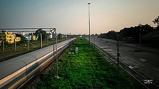
The Barauni–Katihar, Saharsa and Purnia sections of the Barauni–Guwahati line connects Barauni, Saharsa, Purnia and Katihar in the Indian state of Bihar.
North Bihar is a term used for the region of Bihar, India, which lies north of the Ganga river.
Biraul is the subdivisional headquarters of Biraul subdivision, consisting of six blocks of Darbhanga district in Bihar, India. The blocks are Biraul, Ghanshyampur, Gorabauram, Kiratpur, Kusheshwar Asthan and Kusheshwar Asthan East. This region covers the south-eastern part of Darbhanga district.

Purnea Junction railway station, is the railway station serving the city of Purnea in the Purnea district in the Indian state of Bihar. It is a A category railway station of Katihar railway division in Northeast Frontier Railway.
Balwa Gujran is a village in Shamli district in the Indian state of Uttar Pradesh about 85 km from Delhi. Its nearest town is Shamli, about 3 km in distance. Balwa Gujran is a Gurjar village of chauhan gotra as it can be confirmed from it name Gujran.
Majhaul is a large Village in Nauhatta Block in Saharsa District of Bihar State of India, with total 700-800 families residing. It belongs to Kosi Division.

Begusarai railway station is a railway station in the Sonpur division of East Central Railway. Begusarai is better known as the Industrial Capital of Bihar, the birthplace of noted poet Rashtrakavi Ramdhari Singh Dinkar and karmabhoomi of the Great freedom fighter, first chief minister and architect of modern Bihar Dr. Shrikrishna Sinha alias Sri Babu.
Rajdham is a village in Gogari block of Khagaria district of Bihar State, India.

2017 Bihar floods affected 19 districts of North Bihar causing death of 514 people. 2,371 panchayats under 187 blocks of 19 districts of Northern Bihar have been affected in the flood. Around 1.71 crore people were hit by the floods. Over 8.5 lakhs of people have lost their homes, with Araria district alone accounting for 2.2 lakh homeless people. 2017 Flood has broken 9-Year record of deaths In Bihar. Bihar is India's most flood-prone State, with 76% of the population in the North Bihar living under the recurring threat of flood devastation. Devastating flood was caused due to excess heavy rainfall in monsoon season.
Kusheshwar Asthan is a town and a notified area of the Darbhanga in the Indian state of Bihar. Kusheshwar Asthan also known as mithilanchal dev ghar.

