Trinidad and Tobago, a country that relies heavily on industrialisation and tourism, has various transport systems.

The Trinidad and Tobago Defence Force (TTDF) is the military organization responsible for the defence of the twin island Republic of Trinidad and Tobago. It consists of the Trinidad and Tobago Regiment, the Trinidad and Tobago Coast Guard, the Trinidad and Tobago Air Guard and the Defence Force Reserves.

Port of Spain, officially the City of Port of Spain, is the capital city of Trinidad and Tobago, and the third largest municipality after Chaguanas and San Fernando. The city has a municipal population of 37,074, an urban population of 81,142 and a transient daily population of 250,000. It is located on the Gulf of Paria, on the northwest coast of the island of Trinidad and is part of a larger conurbation stretching from Chaguaramas in the west to Arima in the east with an estimated population of 600,000.

Tobago is an island and ward within the Republic of Trinidad and Tobago. It is located 35 kilometres (22 mi) northeast of the larger island of Trinidad and about 160 kilometres (99 mi) off the northeastern coast of Venezuela. It also lies to the southeast of Grenada. The official bird of Tobago is the cocrico.
San Fernando, officially the City of San Fernando, is the most populous city and second most populous municipality in Trinidad and Tobago, after Chaguanas. Sando, as it is also known, occupies 19 km² and is located in the southwestern part of the island of Trinidad. It is bounded to the north by the Guaracara River, the south by the Oropouche River, the east by the Sir Solomon Hochoy Highway, and the west by the Gulf of Paria. The former borough was elevated to the status of a city corporation on 18 November 1988. The motto of San Fernando is: "Sanitas Fortis" - In a Healthy Environment We Will Find Strength. Many local Trinidadians refer to the city with the shortened name "Sando." San Fernando is called Trinidad and Tobago's "industrial capital" because of its proximity to the Pointe-à-Pierre oil refinery and many other petrochemical, LNG, iron and steel and aluminium smelters in places such as Point Lisas in Couva, Point Fortin, and La Brea.

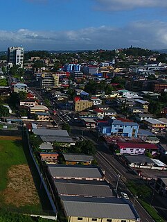
Arima, officially The Royal Chartered Borough of Arima is the easternmost and second largest in area of the three boroughs of Trinidad and Tobago. It is geographically adjacent to Sangre Grande and Arouca at the south central foothills of the Northern Range. To the south is the Caroni–Arena Dam. Coterminous with Town of Arima since 1888, the borough of Arima is the fourth-largest municipality in population in the country. The census estimated it had 33,606 residents in 2011.
Princes Town is a town within the Princes Town Regional Corporation, located on southern Trinidad island in Trinidad and Tobago. The population of the town is 28,335.

Laventille is a ward of Trinidad and Tobago.
Couva is an urban town is in south Trinidad, south of Port of Spain and Chaguanas and north of San Fernando and Point Fortin. It is the capital and main urban centre of Couva–Tabaquite–Talparo, and the Greater Couva area includes the Point Lisas Industrial Estate and the Port of Point Lisas. It is one of the fastest-growing towns in the country. Couva's southern boundary is at the village of California & Point Lisas, and to the north Couva stretches to McBean. To the east of Couva is Preysal. To the west of Couva is the road to Waterloo and Carli Bay, which are located on the Gulf of Paria. Couva was part of the Caroni County. Couva is considered a major power base for the United National Congress (UNC), whose headquarters was previously located here.

Diego Martin is a town and is the urban commercial center and capital of the Diego Martin region in Trinidad and Tobago. Its location in the region is just on the south eastern border, west of the capital city of Port of Spain and east of the town of Carenage. Diego Martin town in the Northern Range was once filled with a number of small valleys but is now a densely populated area. It was named after a Spanish explorer Don Diego Martín. The area was settled by French planters and their slaves in the 1780s. It consists of a cluster of communities including Congo Village, Diamond Vale, Green Hill, Patna Village, Petit Valley, Blue Range, La Puerta Avenue, Four Roads, Rich Plain, River Estate, Blue Basin, Water Wheel, West Moorings, Bagatelle and Sierra Leone.

Trinidad, Kimsantin officially La Santísima Trinidad, is a city in Bolivia, capital of the department of Beni. The population is 130,000. While historically a peripheral city in Bolivia, Trinidad is today an important center for the Bolivian Bovine industry and has enjoyed a modest economic boom in recent years and enjoys an HDI index of above 0.700.

A. N. R. Robinson International Airport is an international airport located on Crown Point, Tobago in Trinidad and Tobago. It is located in the southwesternmost part of the island, near the town of Canaan, and 11 km (6.8 mi) from the capital, Scarborough. The airport is one of two international airports serving the twin isle republic of Trinidad and Tobago. The other airport is located on the island of Trinidad, Piarco International Airport.
Canaan is a small village in southwestern Tobago situated about 5 minutes from Arthur Napoleon Raymond Robinson International Airport, and the popular beaches of Store Bay and Pigeon Point. It is between the towns of Bon Accord and Lowlands. It boasts amenities such as one of the largest supermarkets in Tobago, one of the newest branches of the First Citizens Bank, a popular bakery, car dealership, and a noticeable number of other shops. Canaan is the birthplace of footballer Dwight Yorke.

Saint George is a county in Trinidad and Tobago. It occupies the northwestern portion of the island of Trinidad and is bounded by the Caribbean Sea to the north, the Gulf of Paria to the west, Caroni County to the south and Saint David County and Saint Andrew County to the east. It occupies an area of 912 km2 (352 sq mi). The county includes the Bocas Islands and the towns of Port of Spain and Arima. It also includes the small town of Blanchisseuse and its attractive beach, backed by a forest-fringed lagoon. County Saint George is divided into six Wards: Diego Martin, Saint Ann's, Blanchisseuse, Tacarigua, Arima and San Raphael.

Piarco International Airport is an international airport serving the island of Trinidad and is one of two international airports in Trinidad and Tobago. The airport is located 30 km (19 mi) east of Downtown Port of Spain, located in the adjacent town of Piarco. It is the seventh busiest airport in the Caribbean in terms of passengers served and third busiest in the English-speaking Caribbean, after Sangster International Airport and Lynden Pindling International Airport. The airport is also the primary hub and operating base for the country's national airline, as well as the Caribbean's largest airline, Caribbean Airlines.

Trinidad and Tobago, officially the Republic of Trinidad and Tobago, is the southernmost island country in the Caribbean. Consisting of the main islands Trinidad and Tobago, and numerous much smaller islands, it is situated 130 kilometres south of Grenada and 11 kilometres off the coast of northeastern Venezuela. It shares maritime boundaries with Barbados to the northeast, Grenada to the northwest and Venezuela to the south and west. Trinidad and Tobago is generally considered to be part of the West Indies. According to some geographic definitions, Trinidad and Tobago are also part of the Windward Islands and Lesser Antilles, while other definitions regard Trinidad and Tobago as a separate island group.

Marigot is the main town and capital in the French Collectivity of Saint Martin.
In 2012, the government of Trinidad and Tobago approved the introduction of postal codes starting later that same year. In addition to the postal code implementation the country has embarked on a nationwide address improvement initiative adopting the Universal Postal Union (UPU) S-42 international standard of addressing. The UPU is an arm of the United Nations and is the coordinating body of postal services worldwide. The intent of this exercise is to correct poor addressing in Trinidad & Tobago and assign to each address a six-digit postal code. This change will result in the following:

The history of Tobago covers a period from the earliest human settlements on the island of Tobago in the Archaic period, through its current status as a part of the Republic of Trinidad and Tobago. Originally settled by indigenous people, the island was subject to Spanish slave raids in the sixteenth and early seventeenth century and colonisation attempts by the Dutch, British, French, and Courlanders beginning in 1628, though most colonies failed due to indigenous resistance. After 1763 Tobago was converted to a plantation economy by British settlers and enslaved Africans.


