
The Arctic Archipelago, also known as the Canadian Arctic Archipelago, is an archipelago lying to the north of the Canadian continental mainland, excluding Greenland and Iceland.

The following lists include extreme and significant points of the geography of Canada.

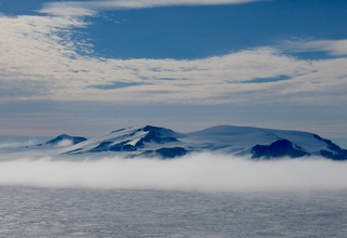
Thurston Island is a largely ice-covered, glacially dissected island, 135 nautical miles long and 55 nautical miles wide, lying between Amundsen Sea and Bellingshausen Sea a short way off the northwest end of Ellsworth Land, Antarctica. The island is separated from the mainland by Peacock Sound, which is occupied by the west portion of Abbot Ice Shelf.
The Amundsen Glacier is a major Antarctic glacier, about 7 to 11 km wide and 150 km (80 nmi) long. It originates on the Antarctic Plateau where it drains the area to the south and west of Nilsen Plateau, then descends through the Queen Maud Mountains to enter the Ross Ice Shelf just west of the MacDonald Nunataks.

The Priestley Glacier is a major valley glacier, about 60 nautical miles long, originating at the edge of the Polar Plateau of Victoria Land, Antarctica. The glacier drains southeast between the Deep Freeze Range and Eisenhower Range to enter the northern end of the Nansen Ice Sheet. It was first explored by the Northern Party of the British Antarctic Expedition, 1910–13, and named for Raymond Priestley, a geologist with the Northern Party.
Tucker Glacier is a major valley glacier of Victoria Land, Antarctica, about 90 nautical miles long, flowing southeast between the Admiralty Mountains and the Victory Mountains to the Ross Sea. There is a snow saddle at the glacier's head, just west of Homerun Range, from which the Ebbe Glacier flows northwestward.
The Victory Mountains is a major group of mountains in Victoria Land, Antarctica, about 100 nautical miles long and 50 nautical miles wide, which is bounded primarily by Mariner and Tucker glaciers and the Ross Sea. They are north of the Mountaineer Range, east of the Freyberg Mountains and south of the Concord Mountains and the Admiralty Mountains. The division between the Victory Mountains and the Concord Mountains is not precise but apparently lies in the vicinity of Thomson Peak.
King Peninsula is an ice-covered peninsula, 100 nautical miles long and 20 nautical miles wide, lying south of Thurston Island and forming the south side of Peacock Sound, Antarctica. It projects from the continental ice sheet and trends west between the Abbot Ice Shelf and Cosgrove Ice Shelf to terminate at the Amundsen Sea.
The Guest Peninsula is a snow-covered peninsula about 45 nautical miles long between the Sulzberger Ice Shelf and Block Bay, in the northwest part of Marie Byrd Land, Antarctica.
The Mariner Glacier is a major glacier over 60 nautical miles long, descending southeast from the plateau of Victoria Land, Antarctica, between Mountaineer Range and Malta Plateau, and terminating at Lady Newnes Bay, Ross Sea, where it forms the floating Mariner Glacier Tongue.
The Desko Mountains are a west-northwest–east-southeast mountain range on Rothschild Island, off northwest Alexander Island in Antarctica. The mountain range spans 20 miles (32 km) from Bates Peak to Overton Peak and rises to about 1,000 metres (3,300 ft) at Enigma Peak, Fournier Ridge.
Morrill Peak is a sharp-pointed peak, about 550 metres (1,800 ft) high, in the Desko Mountains, rising 2 nautical miles (4 km) west-northwest of Thuma Peak in southeast Rothschild Island, Antarctica. It was named by the Advisory Committee on Antarctic Names for Captain Peter A. Morrill, U.S. Coast Guard, Executive Officer on USCGC Westwind in U.S. Navy Operation Deep Freeze in 1967 and 1968.
Thuma Peak is a mainly ice-free peak in the Desko Mountains, rising 2 miles (3 km) northwest of Overton Peak in southeast Rothschild Island in Antarctica. It was named by the Advisory Committee on Antarctic Names for Captain Jack S. Thuma, U.S. Coast Guard.
Welch Mountains is a group of mountains that dominate the area, the highest peak rising to 3,015 metres (9,892 ft), located 25 nautical miles north of Mount Jackson on the east margin of the Dyer Plateau of Palmer Land, Antarctica
The Dana Mountains are a group of mountains just northwest of New Bedford Inlet, bounded by Mosby Glacier on the north and Haines Glacier and Meinardus Glacier on the south, in Palmer Land, Antarctica.
Jøkulskarvet Ridge is a large mountainous ridge with an ice-capped summit, just northeast of Høgfonna Mountain in the Borg Massif of Queen Maud Land. It was mapped by Norwegian cartographers from surveys and from air photos by the Norwegian–British–Swedish Antarctic Expedition (1949–52) and named Jøkulskarvet.
Violante Inlet is an ice-filled inlet 16 nautical miles long, in an east–west direction, and 12 to 15 nautical miles wide, lying between Cape Fanning and Cape Herdman along the east coast of Palmer Land, Antarctica.

The Goodenough Glacier is a broad sweeping glacier to the south of the Batterbee Mountains, flowing from the west shore of Palmer Land, Antarctica, into George VI Sound and the George VI Ice Shelf.
Alyabiev Glacier is a glacier in Antarctica, flowing south from Gluck Peak into Boccherini Inlet and lies about 3 miles (5 km) West of Arensky Glacier on Beethoven Peninsula, Alexander Island, It was named by the USSR Academy of Sciences, in 1987, after Alexander Alyabiev (1787-1851), the Russian composer.