
The Bernese Alps are a mountain range of the Alps, located in western Switzerland. Although the name suggests that they are located in the Berner Oberland region of the canton of Bern, portions of the Bernese Alps are in the adjacent cantons of Valais, Fribourg and Vaud, the latter being usually named Fribourg Alps and Vaud Alps respectively. The highest mountain in the range, the Finsteraarhorn, is also the highest point in the canton of Bern.

The Brienzer Rothorn is a mountain of the Emmental Alps, in Switzerland. With an elevation of 2,350 metres (7,710 ft) above sea level, the Brienzer Rothorn is the highest summit of the range. To its west lies the Tannhorn, whilst to its east are Arnihaaggen, Höch Gumme and the Brünig Pass. On its south side it overlooks Lake Brienz, whilst to the north it looks out over the Waldemme valley.

The Lauberhorn is a mountain in the Bernese Alps of Switzerland, located between Wengen and Grindelwald, north of the Kleine Scheidegg. Its summit is at an elevation of 2,472 m (8,110 ft) above sea level.

The Schreckhorn is a mountain in the Bernese Alps. It is the highest peak located entirely in the canton of Berne. The Schreckhorn is the northernmost Alpine four-thousander and the northernmost summit rising above 4,000 metres in Europe.
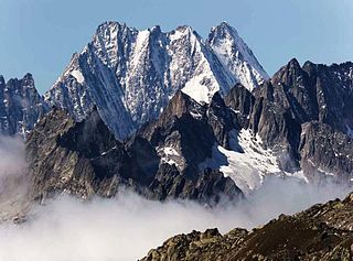
The Lauteraarhorn is a peak of the Bernese Alps, located in the canton of Bern. Together with the higher Schreckhorn, to which it is connected by a high ridge, it lies between the valleys of the Lower Grindelwald Glacier and the Unteraar Glacier, about 10 kilometres southeast of Grindelwald, the closest locality. The Lauteraarhorn belongs to the Aaremassif and is surrounded by large glaciers: the Lauteraargletscher and the Strahlegg-Gletscher and the Obers Ischmeer. Being off the main ridge of the Bernese Alps, all the glaciers surrounding the Lauteraarhorn and the Schreckhorn are part of the Aare basin. The Lauteraarhorn is the second highest summit lying wholly within the canton of Bern. Administratively, it is split between the municipalities of Grindelwald and Guttannen.

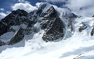
The Tschingelhorn is a mountain of the Bernese Alps, located on the border between the Swiss cantons of Bern and Valais. The summit of the Klein Tschingelhorn on the west is the tripoint between the valleys of Kandertal, Lauterbrunnental and Lötschental. The main summit lies between the Lauterbrunnental and the Lötschental.

The Ebnefluh, also known as the Äbeni Flue and the Ebenefluh, is a mountain of the Bernese Alps, located on the border between the Swiss cantons of Bern and Valais. It lies towards the eastern end of the Lauterbrunnen Wall.
The Nesthorn is a mountain in the Bernese Alps. It is located in the Swiss canton of Valais north of Brig. The mountain lies between the Oberaletsch Glacier on the north and east side and the Gredetschtal on the south side. It is part of the subrange of the Bernese Alps that culminates at the Aletschhorn.

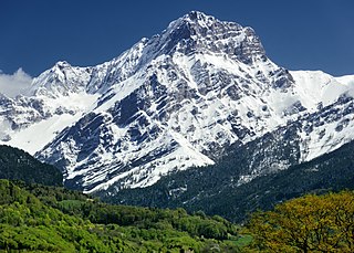
The Dent de Morcles is a 2,969 metres high mountain located at western end of the Bernese Alps, overlooking the Rhone between Martigny and St. Maurice. It is the westernmost summit of the Muverans massif, which in turn is the westernmost of the four distinct mountain massifs of the Bernese Alps that lie west of the Gemmi Pass. Its position at the end of this chain of mountains and the abrupt drop to the wide valley of the Rhone river below make the Dent de Morcles prominently visible from many points in Lausanne and other populated areas on the north and northeastern shores of Lake Geneva.
The Grand Muveran is a mountain of the Bernese Alps, located on the border between the cantons of Vaud and Valais. At 3,051 metres, it is the highest summit of the group lying between the Rhone knee and the Pas de Cheville and the westernmost three-thousander of the Bernese Alps. The closest localities are Les Plans-sur-Bex and Ovronnaz (Valais). It is accompanied by the smaller peak of Petit Muveran.
The Mutthorn is a mountain of the Bernese Alps, overlooking the Kander Glacier in the Bernese Oberland. It lies between the valleys of Kandersteg (west) and Lauterbrunnen (east).

The Dossen is a mountain in the Bernese Alps, overlooking Rosenlaui in the Bernese Oberland. It is located east of the Rosenlaui Glacier. The Dossen is composed of two summits: the northern summit and southern summit.

The Wellhorn is a mountain of the Bernese Alps, overlooking Rosenlaui in the Bernese Oberland. On its eastern side is the Rosenlaui Glacier.

The Faulhorn is a mountain of the Bernese Alps, located between Lake Brienz and Grindelwald in the Bernese Oberland. The summit is 2,681 metres (8,796 ft) high and can be reached by several trails.

The Schwarzhorn is a mountain of the Bernese Alps, located between Brienz and Grindelwald in the Bernese Oberland. With a height of 2,928 metres above sea level, it is the highest summit of the group north of the Grosse Scheidegg Pass. The Schwarzhorn is also the highest point in the municipality of Brienz.

The Wiriehorn is a mountain of the Bernese Alps, located south of Zwischenflüh in the Bernese Oberland.

The Zahm Andrist is a mountain of the Bernese Alps, located south of Kiental in the Bernese Oberland. It lies west of the Hundshorn.

The Loucherhorn is a mountain of the Bernese Alps, overlooking Lake Brienz in the Bernese Oberland. It is located east of the Schynige Platte.
The Grosses Engelhorn is a mountain of the Bernese Alps, located west of Innertkirchen in the Bernese Oberland. It is one of the highest summits of the Engelhörner, the chain between the Reichenbachtal and the Urbachtal.
The Weisshorn is a mountain of the Bernese Alps, located on the border between the Swiss cantons of Bern and Valais. It lies on the main chain of the Bernese Alps, between the Rawil Pass and the Plaine Morte Glacier.
