Related Research Articles

Mere is a small town and civil parish in Wiltshire, England. It lies at the extreme southwestern tip of Salisbury Plain, close to the borders of Somerset and Dorset. The parish includes the hamlets of Barrow Street, Burton, Charnage, Limpers Hill, Rook Street and Southbrook.
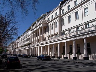
Eaton Square is a rectangular, residential garden square in London's Belgravia district. It is the largest square in London. It is one of the three squares built by the landowning Grosvenor family when they developed the main part of Belgravia in the 19th century that are named after places in Cheshire — in this case Eaton Hall, the Grosvenor country house. It is larger but less grand than the central feature of the district, Belgrave Square, and both larger and grander than Chester Square. The first block was laid out by Thomas Cubitt from 1827. In 2016 it was named as the "Most Expensive Place to Buy Property in Britain", with a full terraced house costing on average 17 million pounds — many of such town houses have been converted, within the same, protected structures, into upmarket apartments.
Richard Shackleton Pope was a British architect working mainly in Bristol. His father was a clerk of works for Sir Robert Smirke, and Pope succeeded him, also working for C.R. Cockerell. He moved to Bristol to work on one of Cockerell's projects and decided to settle in the city, where he became District Surveyor from 1831 to 1874, with considerable influence over building works.
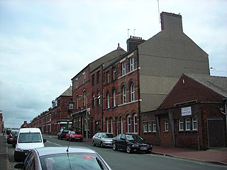
Hindpool is an area and electoral ward of Barrow-in-Furness, Cumbria, England. It is bordered by Barrow Island, Central Barrow, Ormsgill, Parkside and the Walney Channel, the local population stood at 5,851 in 2011. The ward covers the entire western half of the town centre and includes Barrow's main shopping district. Other local landmarks include the Furness College Channelside campus, the Dock Museum and the Main Public Library. Hindpool is also home to two stadia - Barrow Raiders' Craven Park and Barrow A.F.C.'s Holker Street.

Abbey Road is the principal north to south arterial road through Barrow-in-Furness, Cumbria, England.
There are 274 listed buildings in the Borough of Barrow-in-Furness, with about 70% in Barrow-in-Furness itself. The 2015 Heritage Index formed by the Royal Society of Arts and the Heritage Lottery Fund placed the Borough as seventh highest of 325 English districts with an especially high score relating to industrial heritage assets. The Barrow Island conservation area contains dozens of historic shipyard buildings and tenements, while numerous listed buildings can be found lining Abbey Road and Duke Street, which were designed as the principal north to south and east to west thoroughfares of the Victorian planned town. Despite many buildings and structures dating from this era, an abundance of listed buildings exist throughout the Borough that pre-date Barrow, in villages that were consumed by the rapidly expanding town. One notable example being Newbarns village which retains its original 18th century street layout. Significant clusters of listed buildings can be found around the ruins of the 12th-century Furness Abbey and Market Street, the Medieval centre of Dalton-in-Furness. The oldest listed building in Barrow is Furness Abbey, dated 1127 and the newest is the John Whinnerah Institute, completed in 1934.
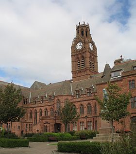
Barrow-in-Furness Town Hall is a Gothic Revival style municipal building in Barrow-in-Furness, Cumbria, England. The building, which serves as the base of Barrow Borough Council, lies within a Conservation Area with Grade II* listed status.

Barrow-in-Furness Main Public Library is a Grade II listed Beaux-Arts style building located at Ramsden Square, Barrow-in-Furness, England. Operated since 1974 by Cumbria County Council, it is the largest library in the town and the present structure, designed by J A Charles was originally built as a Carnegie library with support from the Carnegie Foundation.

As of February 2001, there were 1,124 listed buildings with Grade II status in the English city of Brighton and Hove. The total at 2009 was similar. The city, on the English Channel coast approximately 52 miles (84 km) south of London, was formed as a unitary authority in 1997 by the merger of the neighbouring towns of Brighton and Hove. Queen Elizabeth II granted city status in 2000.

Chapel-en-le-Frith is a town and civil parish in Derbyshire, England.
Duke Street is a road running through the town centre and Hindpool area of Barrow-in-Furness, England. Stretching almost one mile from east to west it connects two major A roads as well as intersecting Abbey Road roughly midway. Designed by Sir James Ramsden as the centrepiece of the 19th century planned town of Barrow, Duke Street is home to three squares alongside many listed buildings including Barrow Town Hall and the Main Public Library. The Forum performing arts centre and Craven Park Stadium are also located on Duke Street.
There are more than 130 listed buildings in the town and borough of Eastbourne, a seaside resort on the coast of East Sussex in England. Eastbourne, whose estimated population in 2011 was 99,400, grew from a collection of farming hamlets into a fashionable holiday destination in the mid-19th century; close attention was paid to urban planning and architecture, and the main landowners the Dukes of Devonshire placed restrictions on the types and locations of development. As a result, much of the resort retains its "basic motif" of late Regency and early Victorian houses, hotels and similar buildings, and also has an extensive stock of 19th-century churches. Coastal fortifications have been strategically important for centuries, and structures such as Martello towers and fortresses have survived to be granted listed status. A few older buildings—priories, manor houses and the ancient parish church—are also spread throughout the borough, whose boundaries take in the dramatic cliffs at Beachy Head and its two listed lighthouses.
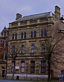
The National Westminster Bank building in Barrow-in-Furness, Cumbria, England is located at the intersection of Abbey Road and Duke Street. It was designed by Paley and Austin architects and built between 1873-74 and has been designated a Grade II listed building by English Heritage. Built for the Lancaster branch of the National Westminster Bank it was a major component of the Ramsden Square scheme, one of the planned town's two main squares and focal points. It is one of three former 'Nat West' properties with listed building status in the Borough and currently houses a carpet shop in the lower floors.

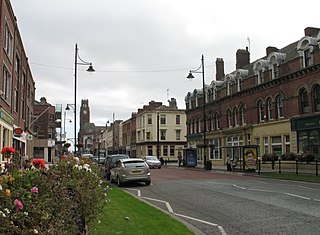
St. George's Square, in Barrow-in-Furness, Cumbria, England is a public space that acted as the centre of the town during the late 19th century. The square now lies in the southernmost fringes of the Central ward close to the Port of Barrow.

Ramsden Square is a square located at the intersection of Abbey Road and Duke Street in Barrow-in-Furness, Cumbria, England. It marks the boundary of the Central and Hindpool wards and now acts as a major roundabout. Ramsden Square was first laid out in the 1840s to act as a focal point of Sir James Ramsden's master plan for the new town of Barrow, separating its burgeoning industries and commercial core. The centerpiece of the square is a statue of Ramsden himself while it is framed by a number of historic buildings including Barrow Central Library, the National Westminster Bank Building and formerly the Barrow Jute Works.

Barrow-in-Furness Strand railway station was the first permanent railway terminus to be built in Barrow-in-Furness, England. Located on the Strand at St. George's Square close to the town's docks its functioning life was short, however the building itself continued to be used as the headquarters of the Furness Railway for a number of years. The station opened in 1863 having replaced a wooden structure which was erected in 1846 at adjacent Rabbit Hill. The station at St. George's square ceased commercial operations in 1882 upon the completion of a new loop line and much larger station at Abbey Road. Barrow-in-Furness Central railway station, later simply renamed Barrow-in-Furness railway station has been the town's primary station ever since.
The Majestic Hotel located at Schneider Square in Barrow-in-Furness, Cumbria, England is a 3-star Grade II listed hotel constructed in 1904. The building was designed by JY McIntosh and contains elements of Edwardian and Jacobean architecture. It is also noted for its striking rounded Flemish gables. £1.7 million was spent on refurbishing the hotel in 2008 by developers One Leisure, although ownership of the Majestic, and its nearby sister hotel the Imperial, have since been transferred. The majority of the building's ground floor level is occupied by an Italian restaurant named Francesca's.
The Imperial Hotel located on Cornwallis Street in Barrow-in-Furness, Cumbria, England is a 4-star Grade II listed hotel built in 1875. The iconic five storey building was designed by architect Thomas Bennet and, like many Barrow buildings, constructed of red brick and sandstone. Other notable features of the building are the balcony located directly above the main entrance and the two decorative lamps standing in front of the hotel, which are also Grade II listed.
Much Wenlock is a civil parish in Shropshire, England. It contains 104 listed buildings that are recorded in the National Heritage List for England. Of these, three are listed at Grade I, the highest of the three grades, six are at Grade II*, the middle grade, and the others are at Grade II, the lowest grade. The parish includes the town of Much Wenlock and the surrounding countryside which contains smaller settlements, including Bourton and Wyke. A high proportion of the listed buildings are in or near the centre of the town, and most are houses, cottages, shops, public houses, many of which are timber framed or have timber framed cores. The other listed buildings in the town include two wells, a church, the remains of a priory, and civic buildings. In the surrounding countryside are country houses and associated structures, farmhouses and farm buildings, a disused windmill, a war memorial, and another church.
William Radford Bryden was an English architect and surveyor who designed various prominent Victorian buildings in Buxton, Derbyshire.
References
- ↑ Historic England. "Town Hall (1197859)". National Heritage List for England . Retrieved 28 January 2015.
- ↑ Historic England. "Alfred Barrow School (1283022)". National Heritage List for England . Retrieved 28 January 2015.
- ↑ Historic England. "Hotel Majestic (1197857)". National Heritage List for England . Retrieved 28 January 2015.
- ↑ Historic England. "Burlington House (11978554)". National Heritage List for England . Retrieved 28 January 2015.
- ↑ Historic England. "4 Duke Street (1209874)". National Heritage List for England . Retrieved 28 January 2015.