
An oil platform, oil rig, offshore platform, or oil and/or gas production platform is a large structure with facilities to extract, and process petroleum and natural gas that lie in rock formations beneath the seabed. Many oil platforms will also contain facilities to accommodate their workforce, although it is also common for there to be a separate accommodation platform bridge linked to the production platform. Most commonly, oil platforms engage in activities on the continental shelf, though they can also be used in lakes, inshore waters, and inland seas. Depending on the circumstances, the platform may be fixed to the ocean floor, consist of an artificial island, or float. In some arrangements the main facility may have storage facilities for the processed oil. Remote subsea wells may also be connected to a platform by flow lines and by umbilical connections. These sub-sea solutions may consist of one or more subsea wells or of one or more manifold centres for multiple wells.

A lock is a device used for raising and lowering boats, ships and other watercraft between stretches of water of different levels on river and canal waterways. The distinguishing feature of a lock is a fixed chamber in which the water level can be varied; whereas in a caisson lock, a boat lift, or on a canal inclined plane, it is the chamber itself that rises and falls.

Bristol Harbour is the harbour in the city of Bristol, England. The harbour covers an area of 70 acres. It is the former natural tidal river Avon through the city but was made into its current form in 1809 when the tide was prevented from going out permanently. A tidal by-pass was dug for 2 miles through the fields of Bedminster for the river, known as the "River Avon New Cut", "New Cut", or simply "The Cut". It is often called the Floating Harbour as the water level remains constant and it is not affected by the state of the tide on the river in the Avon Gorge, The New Cut or the natural river southeast of Temple Meads to its source.

In geotechnical engineering, a caisson is a watertight retaining structure used, for example, to work on the foundations of a bridge pier, for the construction of a concrete dam, or for the repair of ships. Caissons are constructed in such a way that the water can be pumped out, keeping the work environment dry. When piers are being built using an open caisson, and it is not practical to reach suitable soil, friction pilings may be driven to form a suitable sub-foundation. These piles are connected by a foundation pad upon which the column pier is erected.
Döbling is the 19th District in the city of Vienna, Austria. It is located on the north end from the central districts, north of the districts Alsergrund and Währing. Döbling has some heavily populated urban areas with many residential buildings, and borders the Vienna Woods. It hosts some of the most expensive residential areas such as Grinzing, Sievering, Neustift am Walde and Kaasgraben and is also the site of many Heurigen restaurants. There are also some large Gemeindebauten, including Vienna's most famous, the Karl-Marx-Hof.
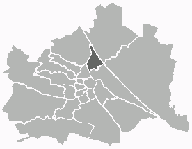
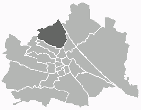
Brigittenau is the 20th district of Vienna. It is located north of the central districts, north of Leopoldstadt on the same island area between the Danube and the Danube Canal. Brigittenau is a heavily populated urban area with many residential buildings.

The Donaukanal is a former arm of the river Danube, now regulated as a water channel, within the city of Vienna, Austria. It is 17.3 kilometres (10.7 mi) long and, unlike the Danube itself, it borders Vienna's city centre, Innere Stadt, where the Wien River (Wienfluss) flows into it.

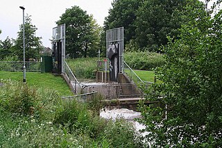
Karl Johanslussen is a lock and a sluice, along the Söderström river connecting and controlling the flood discharge between Riddarfjärden, the easternmost part of Lake Mälaren, and Saltsjön, the section of the Baltic Sea reaching into central Stockholm, Sweden. The lock is 75 metres long, 10 metres wide and 3.90 metres deep. The maximum height is 3.8 metres. The lock is closed from 2016 to 2021 due to large reconstruction works in the area.

An LNG carrier is a tank ship designed for transporting liquefied natural gas (LNG).

Wilhelm Freiherr von Engerth was an Austrian architect and engineer, known for being the designer of the first practical mountain locomotive. For his services he was elevated in 1875 to the baronetcy.

For a long time, it was not necessary to build a Harbour in Vienna, because the existing natural landing points were sufficient for the level of trade on the Danube. It was only when steamships began to arrive in great numbers that a harbour offering safe berths became essential. Even then however, goods were for the most part loaded and unloaded at an unenclosed river harbour that was established at the end of the 19th century.

The Nussdorf weir and lock are works of hydraulic engineering located in the Viennese suburb of Nussdorf at the point where the Donaukanal leaves the Danube. The weir and lock were built following the adoption of a new law in July 1892, which also authorised the construction of the Vienna Stadtbahn and the transformation of the Donaukanal into a winter harbour.
Riet is a village in the town of Vaihingen an der Enz, Germany. The population is around 900, and it is about 5 kilometres (3.1 mi) south of central Vaihingen.

A caisson is a form of lock gate. It consists of a large floating iron or steel box. This can be flooded to seat the caisson in the opening of the dock to close it, or pumped dry to float it and allow it to be towed clear of the dock.
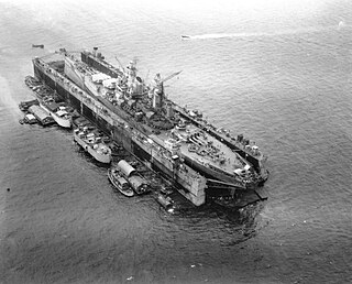
USS ABSD-2, later redesignated as AFDB-2, was a ten-section, non-self-propelled, large auxiliary floating drydock of the US Navy. Advance Base Sectional Dock-2 was constructed in sections during 1942 and 1943 by the Mare Island Naval Shipyard in Vallejo, California for World War II. Her official commissioning ceremony took place on 14 August 1943 with CDR. Joseph J. Rochefort in command. With all ten sections joined, she was 927 feet long, 28 feet tall, and with an inside clear width of 133 feet 7 inches. ABSD-2 had a traveling 15-ton capacity crane with an 85-foot radius and two or more support barges. The two side walls were folded down under tow to reduce wind resistance and lower the center of gravity. ABSD-2 had 6 capstans for pulling, each rated at 24,000 lbf (110,000 N) at 30 ft/min (0.15 m/s), 4 of the capstans were reversible. There were also 4 ballast compartments in each section.
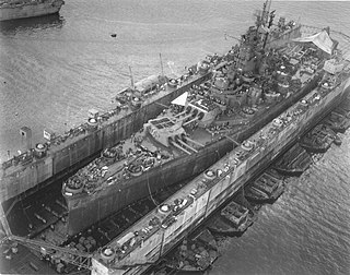
ABSD-6 is an advanced base sectional dock which was constructed of nine advance base docks (ABD) sections for the US Navy as an auxiliary floating drydock for World War II. ABSD-6 was built by Mare Island Naval Shipyard at Vallejo, California. ABSD-6 was commissioned on 28 September 1944. Advance Base Sectional Dock-6 was constructed in sections during 1942 and 1943. Each section are 3,850 tons and are 93 feet long each. Each Section had a 165 feet beam, a 75 feet molded depth and had 10,000 tons lifting capacity each. There were 4 ballast compartments in each section. With all nine sections joined, she was 825 feet long, 28 feet tall, and with an inside clear width of 133 feet 7 inches. ABSD-2 had a traveling 15-ton capacity crane with an 85-foot radius and two or more support barges. The two side walls were folded down under tow to reduce wind resistance and lower the center of gravity. ABSD-6 had 6 capstans for pulling, each rated at 24,000 lbf (110,000 N) at 30 ft/min (0.15 m/s), 4 of the capstans were reversible.

USS ABSD-4, later redesignated as AFDB-4, was a nine-section, non-self-propelled, large auxiliary floating drydock of the US Navy. Advance Base Sectional Dock-4 was constructed in sections during 1942 and 1943 by the Mare Island Naval Shipyard in Vallejo, California for World War II. With all ten sections joined, she was 927 feet long, 28 feet tall, and with an inside clear width of 133 feet 7 inches. ABSD-4 had a traveling 15-ton capacity crane with an 85-foot radius and two or more support barges. The two side walls were folded down under tow to reduce wind resistance and lower the center of gravity. ABSD-4 had 6 capstans for pulling, each rated at 24,000 lbf (110,000 N) at 30 ft/min (0.15 m/s), 4 of the capstans were reversible. There were also 4 ballast compartments in each section.

USS ABSD-5, later redesignated as AFDB-5, was a nine-section, non-self-propelled, large auxiliary floating drydock of the US Navy. Advance Base Sectional Dock-5 was constructed in sections during 1943 and 1944 by the Chicago Bridge & Iron Company in Morgan City, Louisiana for World War II. With all nine sections joined, she was 825 feet long, 28 feet tall, and with an inside clear width of 133 feet 7 inches. ABSD-5 had two traveling 15-ton capacity crane with an 85-foot radius and two or more support barges. The two side walls were folded down under tow to reduce wind resistance and lower the center of gravity. ABSD-5 had 6 capstans for pulling, each rated at 24,000 lbf (110,000 N) at 30 ft/min (0.15 m/s), 4 of the capstans were reversible. There were also 4 ballast compartments in each section.

Jedlesee is a suburb of Floridsdorf, the 21st district of Vienna. An independent community until 1894, it was joined along with Leopoldau, Donaufeld, Floridsdorf and Neu Jedlesdorf to the greater Floridsdorf municipality, becoming part of Vienna in 1904. Jedlesee is most notable for being the site of the estate of Countess Anna Maria Erdődy, close friend and patron of Beethoven, who stayed there with her on numerous occasions between 1805 and 1818.
A tilting weir or tilting gate is a moveable weir being a type of weir used for raising and lowering a head of water by controlling the flow of water to a lower catchment area or drainage basin. Typically the plate or paddle of the tilting weir moves up and down in a narrow duct by titling, pivoting or rotating on its bottom horizontal axis - which opens or closes the tilting weir thus controlling the flow of water out of the higher drainage basin. For example, a reservoir, lake, duct, channel, river, pond, dyke or ditch to a lower lying area or catchment or drainage basin.

