
Lake Hood Seaplane Base is a state-owned seaplane base located three nautical miles (6 km) southwest of the central business district of Anchorage in the U.S. state of Alaska. The Lake Hood Strip is a gravel runway located adjacent to the seaplane base. The gravel strip airport's previous code of has been decommissioned and combined with as another landing surface.

Kenmore Air Harbor is a public-use seaplane base at the northern end of Lake Washington and 1 nmi south of the central business district of Kenmore, Washington, U.S. It primarily serves western Washington and parts of southwestern British Columbia. The base is primarily used by regional seaplane airline Kenmore Air.

Iliamna Airport is a state-owned public-use airport located three nautical miles (5.5 km) west of the central business district of Iliamna, in the Lake and Peninsula Borough of the U.S. state of Alaska.
Sky Harbor Airport & Seaplane Base or Sky Harbor Airport is a public airport in Duluth, Minnesota, United States. It is located near the Wisconsin border, between Superior Bay and Lake Superior. The airport is six nautical miles (11 km) southeast of the central business district of Duluth, Minnesota, on Minnesota Point within its city limits.

Grand Marais/Cook County Airport is a county-owned public-use airport located eight miles (13 km) northwest of the central business district of Grand Marais, a city in Cook County, Minnesota, United States. This airport replaced the former Devil's Track Municipal Airport located on the shore of Devil's Track Lake, one mile (1.6 km) south of the current airport.
Baudette International Airport is a county-owned public-use airport located one mile (2 km) north of the central business district of Baudette, a city in Lake of the Woods County, Minnesota, United States. Also known as Baudette International Airport & Seaplane Base, it is located on the Rainy River, which is the border between Minnesota in the U.S. and Ontario in Canada.
Grand Isle Seaplane Base is a private-use seaplane base located three nautical miles (6 km) northeast of the central business district of Grand Isle, in Jefferson Parish, Louisiana, United States. It is owned by the Freeport Sulphur Company.
Maple Lake Municipal Airport is a city-owned, public-use airport located one nautical mile (2 km) northeast of the central business district of Maple Lake, a city in Wright County, Minnesota, United States. It is located on Maple Lake and is also known as Maple Lake Municipal Airport & Seaplane Base. The current full name is now Maple Lake Municipal - Bill Mavencamp Sr Field.
Klawock Seaplane Base is a public use seaplane base owned by and located in Klawock, a city in the Prince of Wales-Hyder Census Area of the U.S. state of Alaska. It is included in the National Plan of Integrated Airport Systems for 2011–2015, which categorized it as a general aviation facility.
Shawano Municipal Airport is a city and county-owned public-use airport located one nautical mile (2 km) northeast of the central business district of Shawano, a city in Shawano County, Wisconsin, United States. It is included in the Federal Aviation Administration (FAA) National Plan of Integrated Airport Systems for 2021–2025, in which it is categorized as a local general aviation facility. The airport is located on Shawano Lake and has a landing area for seaplanes.
Burnett County Airport is a county-owned public use airport located three nautical miles (6 km) north of the central business district of Siren, in Burnett County, Wisconsin, United States. It is included in the Federal Aviation Administration (FAA) National Plan of Integrated Airport Systems for 2021–2025, in which it is categorized as a local general aviation facility.

Tokeen Seaplane Base is a public use seaplane base located in Tokeen, in the Prince of Wales-Hyder Census Area in the U.S. state of Alaska.
Cloquet Carlton County Airport is a county-owned public-use airport located three nautical miles (6 km) southwest of the central business district of Cloquet, a city in Carlton County, Minnesota, United States.
Newtok Airport is a state-owned public-use airport located one nautical mile (1.85 km) west of the central business district of Newtok, a village in the Bethel Census Area of the U.S. state of Alaska. There is also a nearby seaplane landing area known as Newtok Seaplane Base, located at 60°55′25″N164°39′22″W on the Ninglick River.
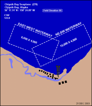
Chignik Bay Seaplane Base is a public-use seaplane base serving Chignik, a city in the Lake and Peninsula Borough of the U.S. state of Alaska.
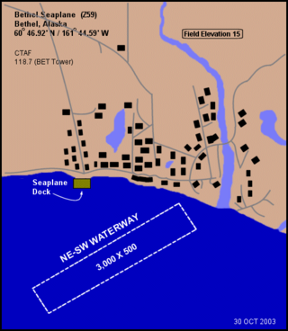
Bethel Seaplane Base is a public use seaplane base located on the Kuskokwim River in Bethel, a city in the Bethel Census Area of the U.S. state of Alaska.
Friday Harbor Seaplane Base is a public use seaplane base located adjacent to Friday Harbor, on San Juan Island in San Juan County, Washington, United States. It is owned by the Port of Friday Harbor.
Roche Harbor Seaplane Base is a public-use seaplane base located adjacent to Roche Harbor, on San Juan Island in San Juan County, Washington, United States. It is owned by the Roche Harbor Resort.
Rosario Seaplane Base is a public-use seaplane base located adjacent to Rosario on Orcas Island in San Juan County, Washington, United States. It is owned by the Rosario Resort.
Naukati Bay Seaplane Base, formerly known as Nichin Cove Seaplane Base, is a public use seaplane base located at Nichin Cove on the east side of Tuxekan Island, in the Prince of Wales-Hyder Census Area of the U.S. state of Alaska. It is owned by the Naukati Bay Community and located 2 nautical miles (4 km) southwest of Naukati Bay which is on Prince of Wales Island.

